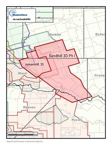
Referencing a post from Reeves County TX in July 2017 for early phase(s) of Schlumberger’s 3D WAZ survey of West Texas. My lease is in north central Winkler County so this may be for new Phases. Previous post refers to $20 per acre, but the Agent for Dawson Geophysical Co (sub-contractor doing the survey) said he wasn’t authorized to offer any payment. Did anyone else receive this Permit request and/or have experience with getting paid? Logistically what would Schlumberger do with the results? - sell the info to operators if they find untapped reserves? My 160 acres has 3 plugged wells on it as does the whole Section (Blk 74, Sect 16)… As usual, I appreciate any information. .
Depends upon the company doing the shoot, but I have not been paid. Since they needed to cut a path around my pond, I got a nice little road around the pond out of it.
If you are the surface owner, then you should be paid. You can otherwise refuse to allow the survey.
Texas Mineral Owner’s Implied Right to Use the Surface
(excerpt) "Ownership of the mineral estate carries with it an implied right to use the surface estate as is reasonably necessary to explore, develop, drill, produce, market, transport, and store the minerals from the land. What does that mean?
Over time, reasonable use of the surface has been interpreted in Texas to mean the mineral estate owner (or, far more frequently, the operator to which the mineral owner has leased his or her minerals) can use the surface to:
enter the property covered by the mineral lease, explore for the oil and gas by using seismic trucks or other exploration methods, construct roads, well sites, and gathering pipelines serving wells on the property at a location of the mineral owner’s choosing, …"
Thanks for the input.
Schlumberger announced today the completion of the acquisition of its extensively industry-funded Sandhill 3D wide-azimuth (WAZ) multiclient survey covering 540 mi2 in Winkler, Ward, Crane, and Pecos Counties of West Texas. The newly acquired high-density Sandhill 3D data will be combined with 221 mi2 of Jumano 3D data, resulting in a continuous merged volume stretching from the Central Basin Platform to the Delaware Basin, covering the entire width of fill zone. Superior seismic resolution will increase confidence for this geologically complex area.
Regions of interest
The western portion of the survey falls within the Delaware Basin, and the eastern is in the Central Basin Platform. This span enables greater understanding of deposition in the western Delaware Basin as well as the complex transition between basin and platform. The survey also includes parts of the Capitan Reef and the Cenozoic fill zone.
Enverus image incl. Delaware, Central Basin Platform, and Midland: https://images.squarespace-cdn.com/content/v1/5f89a98d2882df056ac08e80/1603456151809-BWGIA5QC4FIZ6E3KGESY/Activity-Map.png?format=750w
Keep in mind that the right of the oil and gas lessee to use the surface is limited to its own use related to the lease. The lessee cannot allow third parties to use the surface for other purposes. Seismic may be an odd area. The lessee may be allowing Schlumberger to conduct seismic in return for giving data access to the lessee. The question is whether the addition of the seismic data to Schlumberger’s library for sale to other unrelated companies is allowable surface use under Texas law. That is why the surface owner is paid damages by the seismic company. So if CMikeD owns the surface, he should demand compensation. If he only owns minerals, then he will not be paid.
I have been paid by a geophysical company for the right to shoot a mineral rights only parcel in Texas. I have no idea if this might have allowed the geophysical company to ride roughshod over the surface owner. And I do not know if the surface owner was also compensated. Is it true that authorization by the owner of a fraction of the minerals in an undivided section will allow a geophysical company to move forward? Could the geophysical company have taken a transverse look at my minerals without having ever placed sensors on the surface above them?
Yes, it only takes a small amount of mineral owner permission to agree to the survey.
WAZ means wide-azimuth survey. So they can shoot sound waves from a large distance away and have the geophones not located over your minerals and still pick up information.
Depending upon the type of survey, they may do very little damage or none at all to the surface, so depending upon the situation, no offers to compensate may be reasonable. Just depends upon the shoot and who is doing it.
This topic was automatically closed after 90 days. New replies are no longer allowed.
