Since February 2020, I’ve received 2 offers from Enerlex, Inc. from Broken Arrow, Oklahoma to buy my mineral rights in Pecos County. I have declined both offers and have no intention of selling, but they offered me about 3 times the amount I’m usually offered. I’m curious to know what activity is going on there in regard to oil and gas, and with Enerlex in particular. The area specifically is Block 8, Section 75, Abstract 231. I would appreciate any information about this.
This link will open the RRC’s GIS map viewer on an approximately 2.5 mile long well which, if drilled, will go through your section. Use the vertical magnification bar on the left side of the map to zoom out one or two clicks for better visualization and/or use your mouse to drag the map. This link opens the permit.
1 Like
Thanks so much, AJ11! I have to admit these are maps that I’ve never seen before, so I’ll be educating myself about them.
1 Like
You’re welcome, odie! The lines with green dots represent producing horizontal wells and the lines with blue circles represent permitted horizontal wells. You may be getting higher offers because of the permit. It is possible drilling is imminent or has already begun. Two wells in the sections to your immediate west have produced a total of ~530,000 barrels of oil since April 2019 and are still producing ~15,000 barrels of oil in December 2020. You can see that even a small interest in this type of production could have significant value.
1 Like
A small interest is all I’ve ever had in any of these wells so it probably still won’t be a large royalty but I’m interested to see what comes of it. If I’m reading the GIS viewer correctly, I see well #41H and the line runs through the middle of Section 75. I’m a total newbie to these kinds of maps so maybe I’m just overlooking it but can you tell me where you find the information about nearby producing wells and their output like the ones you mentioned west of my section? I see that I can hover over the dots and circles and see the depth, who’s drilling, etc.
Click on the “Identify” icon, a circumscribed blue “i” at the top of the map viewer, choose “wells” and then put your cursor over the dot/well of interest. Left click and a pop-up menu will appear. Scroll down and choose the “production data query/(pdq)” link. Adjust the date range at the top of the opened page. Another way to search production is through the Texas Comptroller’s CONG page. Search this forum for instructions on how to use that option.
That 41H permit is from mid-year 2019. Jagged Peak was sold to Parsley since then, who was then sold to Pioneer, who has roughly 50,000 locations to drill in the Permian. So I don’t know that I would expect anything to happen there soon. Perhaps it will, but drilling on the edge of the Delaware vs other places doesn’t seem to make a ton of sense to me from a Pioneer perspective.
Yes, as AJ says, the western offsets are pretty decent wells. You are a mile updip. Might still be ok.
As far as Enerlex, Inc., pretty sure they are just random dudes trying to buy your mineral rights. No clue why they would have tripled it unless they offered you based on $25 oil in 1Q2020 and are looking at $60 oil today.
Basically Pecos County is dead as heck right now. The county had 26 rigs in 3Q2019. Averaged 1.4 rigs since July 2020. XOM collapsed all drilling to pay their insane dividend. Parsley sold to Daddy. Diamondback has better things to drill. Most of the Southern Pecos folks went ass up, Contango/Crimson Halcon etc. I have some minerals in Pecos, so you’ll have to pardon my pessimistic outlook. It’s pretty bleak vs 2019.
No intention of selling simplifies matters for you.
1 Like
Thanks both of you for the information. My brother is also doing some checking on this too. Don’t worry about sounding pessimistic, NMoilboy, I’m certainly not counting on anything. It would be nice if something came of it but I won’t be betting the farm on it LOL.
I’m not counting on anything in Pecos County either and haven’t in years. I need a favor however: My property is described as Blk 1 Sec 9 including tracts 33-48 in the Ft Stockton Irrigated Land Co. I had a link to view the exact location but I can’t find it. Scrolling through the GLO or GIS Viewer on a 15" laptop is difficult at best. Pecos County isn’t as well laid out as Reeves County and I would appreciate it if someone could send me a screenshot or link to the property described. Thanks in advance!
Hi Daniel, I can see why this area is hard to find. Noticed that you have asked on this forum several times previously. I couldn’t really find it until I found some older posts. In one, a well with API # 42-371-36603 was referenced… Fort Stockton Gas Unit 6. This is in A-762 at Latitude 30.928N and Longitude -102.861. In the future if you search the RRS or GLO map you can search for Pecos County A-762, or use the longitude and latitude, or search this forum for “Stockton GU 6” and you should be able to re-find the map.
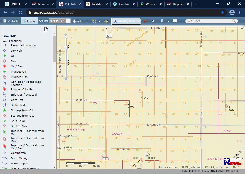
PeteR…thanks very much. Now that I have the abstract it really helps. I have recently been approached about selling it, but it never got to an offer. I doubt it is worth much anyway. I appreciate your help!
I did a search on this forum about Enerlex and in the thread “Questions on an offer from Enerlex for land in Pecos County, Texas” I found a post by TennisDaze who said that [if there were royalties in suspense], “The buyer is hoping to get that accumulated royalty money.” My brother was also told something like this when he did some research on it. What doesn’t make sense to me is if Enerlex can locate people who own mineral rights in order to make an offer, it seems that the oil company should also be able to find people who have royalties in suspense. As I’ve said, I’m a dummy about all this so if anyone has an answer to that one I’d appreciate learning more.
Some companies are in the business of purchasing minerals. They notice that there are unknown mineral owners in a well, most frequently because heirs did not file probate in the deed records. Perhaps because the heirs thought it was too expensive to bother with probate and filing documents for non-producing minerals during a time of low prices and little activity or perhaps because they had no idea that there were any minerals.
Then the buyer traces the descendants and heirs, looking for probate records, birth records, obituaries, etc., to determine the descendants. This can cost a lot of time and money. Then the buyer offers to purchase the minerals, with the agreement that the seller/heir will help file affidavits or other documents to establish title.
The buyer is in the business to make money. This is not economic for the oil company to expend money and time to find the heirs of what are generally small mineral interests. The oil company will drill and produce and wait for heirs or a buyer to establish title and come forward. It is the responsibility of the mineral owner, like any property owner, to keep track of records and pay to file deeds, probate, affidavits, etc., to keep their title clear. Unfortunately, many people do not keep good records, or throw out documents, such as deeds, leases, division orders, which would enable their children and grandchildren to find the minerals.
2 Likes
Thanks for the quick and thorough answer. My mother inherited these mineral rights from her father who worked for an oil company. He always told his wife and kids to never sell their mineral rights and my brother and I have followed that advice. When my mother died in 1999, my father had an attorney transfer all of her oil holdings (small amounts, nothing huge) to my brother and me. We’ve been getting oil checks and division orders from several different companies ever since so it would seem that the proper actions were taken. We just weren’t aware of anything in Pecos County; most of our oil checks come from wells in south Arkansas although some of the companies are located in Texas. Since I’ve lived at the same address for 35 years, I’m not hard to find. Anyway, thanks again for the info. I doubt that anything will come of this but we’ll keep researching.