I own minerals in Section 10, Township 04N, Range 11E in Hughes County. There are 4 wells (4 Shirley wells) that are leased in this section so I thought I should be getting royalties. However, BP America (the operator) says that the bottom hole is in Section 15, Township 04N, Range 11E in Hughes County and is therefore producing out of this section and NOT Section 10 so no royalties for moi. Can someone explain this to me? Thanks for any assistance. Robert
This is the geologic exhibit used in 15-04N-11E for the Increased Density application. Note, only the surface locations are on your section. No perforations in the producing zone were made by BP on your property.
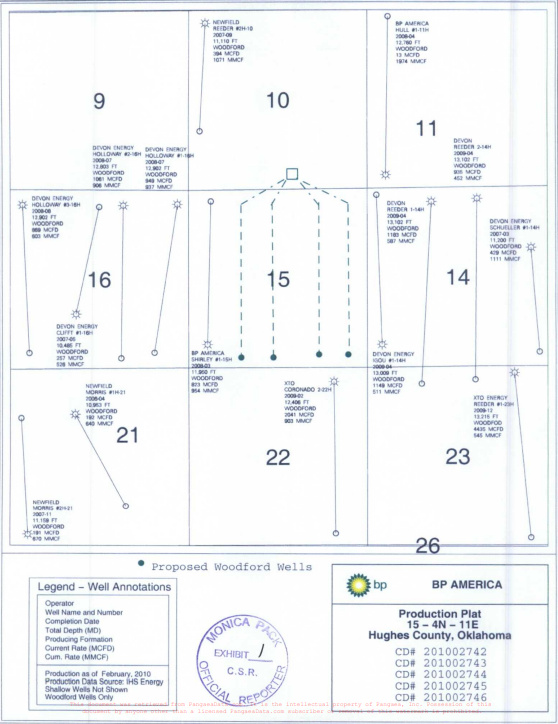
You only get paid on minerals if they have perforations in them. With horizontal wells, they frequently have the surface location in a contiguous section. They drill the vertical hole in the SL section and make the turn in that section, then go into the next section for the lateral part of the well in the prospective horizon which is then perforated. They have to have an easement at the lease line so don’t perforate that.
However, don’t lose heart. There is another set of wells that have permits in section 3 to your north and went into 10. You had the benefit of the same strategy on the Reeder wells back in 2010.
James H. and M. Barnes, thank you for helping me understand this situation.
Can you advise as to the best source (most accurate, latest updates) for confirming leased minerals where I can find definitive information if a section is under lease or if a particular royalty owner in a specific section is either currently under lease (within lease time frame) or held by production?
Also, can you advise as to the best source (most accurate, latest updates) for finding out about wells that have been permitted and the sections that will be perforated? Another way of putting this, where can I find out about the permitted wells in M-Barnes’ statement “There is another set of wells that have permits in section 3”?
I am trying to find out if Section 10 will be leased and if so when (approximately) will the leasing process begin or if it has already been leased (currently under lease). Where can I find out about these permitted wells coming from Section 3 into Section 10?
Thank you for any guidance on this. Robert
You can find the most recent permits on the Oklahoma Corporation website. That is the official repository. (There may be permits in house at a company, but that is not official). The surface location may not be on your minerals, so you need to search in the sections nearby. Use 0304N11E in the location box to look up the Reeder wells that went from 3 into 10. Permits are 1000. Spud dates are 1001A. Completion reports are 1002A.
http://imaging.occeweb.com/imaging/OGWellRecords.aspx
Only the companies know when leasing will occur. Current leases may be found using subscription sites or your can hunt for free on https://okcountyrecords.com. Printing is a small fee. If you are held by production, there will likely be no current leasing unless it is for a new zone that is not held by a lease. You can search by location, name of person, etc. If wells were drilled within the primary term of a lease and they are still productive, then the lease is in its secondary term and is considered HBP until those wells cease production. Those Reeder wells look like they will go for a good long time.
Hi Robert,
The best source with the most accurate and latest updates for confirming leased minerals where you can find definitive information if a section is under lease, up to and including specific royalty owners, is the County Clerk’s Office in Hughes County, Oklahoma. Sometimes documents in Hughes are missing from the Courthouse, and you can typically find those at Atlas Abstracts in Holdenville or at one of the Tribal Agencies.
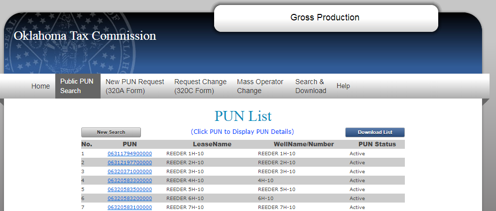
The best source for finding out about wells that have been permitted and the sections that will be perforated is through the Oklahoma Corporation Commission, the State of Oklahoma’s regulatory authority for Oil & Gas matters. M_Barnes gave you some good direction there. One of my favorite tools for checking to see if a well exists in a section is to use the Public PUN Search with the Oklahoma Tax Commission. You can do a Google search to come up with the web page.
There is no all-in-one-spot online repository for the type of information you are seeking. Some of the information you need may not be online at all, but located at the Courthouse. Bits and pieces of the information you need to make your determinations are all scattered about. This is why the “Landman” exists.
As to Section 10, it would appear that your property is/was already leased prior to circa 2006 and has been held by production by the Reeder wells ever since. I doubt you will receive a new lease offer for some time as you have 7 active horizontal wells on your property effectively holding by production you until production ceases on those wells for typically a period of 24 months. Even if the operator was going to drill new wells in here, they most likely would keep at least one of the older wells in production until they got the new well drilled so that they can keep you on the same terms.
Here is a screenshot from the OTC. I hope this helps:
Thank you, M Barnes. Excellent info. Wish I had known this years ago.
Ever thought about putting together a book on “Mineral Owners Information Sources” including the process and rules for accessing and using these sources?
Funny you should ask. I will have an article on that very thing in the OK NARO newsletter soon.
Those Reeder wells are probably going to be online for a very long time. Horizontal wells can last decades.