Organizing leases and companies

Does anyone have any suggestions for how to organize our mineral rights? We have interest in several counties and I have files by counties, and other files by leases and then more files by companies. Then I’ve tried having an excel file!! I was trying to organize to make it quick and easy to locate information but it seems I now have so many different places to look for information!! Does anyone have a good method to organize deeds, leases and companies? How important is it to know the wells? Do I need that information as well?

Thank you for any suggestions!!

Use what works for you! I am a geologist, so I organize by location as it makes the most sense to me. Mineral rights are tied to a location on the earth, so that is why I file that way. I will explain the physical and digital files first.

I file everything in my paper files (and a backup digital file system on Dropbox) by State, County, Township, Range, Section, subsection if needed (or abstract). (Largest entity to smallest) . Each mineral tract has its own file folder with subfolders in it. I label it ex: OK-Stephens-01N-01W-1 Name of tract (my grandfather named everything by the farmer he bought it from-we keep for historical purposes) (net acres)

Inside front cover of master folder-Map of location of the tract.

Subfolder one-at the back. Original documents such as deeds, copy of will or probate that refers to that section, etc. Oldest at the back, newest at the front. Originals are kept in a fireproof safe or safety deposit box.

Subfolder two -Misc. Correspondence of any kind. Offers, notes from newspapers or online, etc. In date order, oldest at the back.

Subfolder three-Lease information-specific correspondence regarding a lease. Actual copy of the lease and copy of the check received,

Within the Lease folder-or stand alone #4 if you only have one lease… A-Well folders-AFE, permit, spud, survey, completion, production information, Division Orders for each well . Chronological order with oldest at the back and newest at the front. (If multiple wells, each gets their own folder.)

B-Commission information- in OK, I put all of the OCC documents that go with the tract- spacing, increased density, well location, application for well, poolings, etc. (all are online)

C-Payments for each well. Keep copies of your stubs for seven years for IRS purposes. We file our accounting records separately, but if you only have one or two wells by different operators, then you can file how it makes sense to you.

Yes, you need to keep track of every single well and who is paying on it!

I have massive Excel master lists each with their own set of columns, but always tied to the State, Co, Township, Range, Section, etc.
Examples of my lists-

-Composite master list of properties

-Composite master list of all wells-make sure you have that API number is that is the unique code for that well

-List of currently drilling wells

-Composite master list of all Division Orders

-Watch list of OCC pending cases. I file them digitally with the case number first, then what they are- and then a date.

-Useful online links gleaned from everywhere-most of them from this forum or from NARO (National Association of Royalty Owners)

-a running calendar of dates of when things are due such as taxes, pooling orders, when first checks should arrive from a new well, when interest is due, lease expirations, etc.

-Master activity list of every inquiry, OCC item, pending well

I have other master folders (mostly digital) regarding legal issues, bankruptcies, corporate presentations from my major operators (they may have good maps, clues on production, etc.)

Before you panic. This took a while! Most everything in my files was found by free searches or minimal expense from www.okcountyrecords.com. Luckily, I inherited good files from the two generations before me, so could slide right in and take it from filing cabinets to scanning and converting to digital records.

Hope this gives you a starting point. Feel free to ask questions.
I separate by State, then County, then Range, Township & then section. I keep all the well information in the pertinent section file.

I also have an excel spreadsheet that I use to keep track of each companies revenue, without well names, on a monthly basis.

For my working interests I have a spreadsheet for each well.

Todd and Martha have great advice:

There are also mineral management programs. I have seen these at NARO conventions (National Association of Royalty Owners). Not sure of the cost.

There are also mineral managers who, for a fee, will manage minerals.

I’m just getting started. For now, I have two mains sets of records.

Geographic - so a folder for each county, then by Section/Township/Range. So within my Stepehens County, folder I have folders for each mineral interest we own. So a fold for S1-T1N-R1W, then another folder for S2-T2N-R2W, etc, etc, etc. Into that goes everything I know about that particular parcel of land. Deeds, leases, division orders go here.

Then I have file folders for each of the current or most recent production. Copies of the leases, division orders, correspondence with the production company, and copies of checks.

And, then I’ve started an excel spreadsheet to track payments as received.

Its not perfect, but it works for me - so far, But, then I’m learning as I go.

Rob

Thank you! That’s just about what I’ve done. I have one file with deeds and descriptions. Another for companies and a third for countries and leases. My husband started an excel file but I don’t know how he’s working it. I appreciate your input and everything else! I’m just learning how to maneuver in this web site!

Oh my goodness!! Y’all are so incredible!! Ms. Barnes! What a font of information you are!! I so appreciate all the information each of you has shared with me!!! I certainly have some great ideas to get my files in order now!! Thank you all!!!

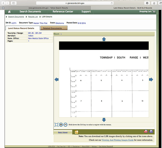
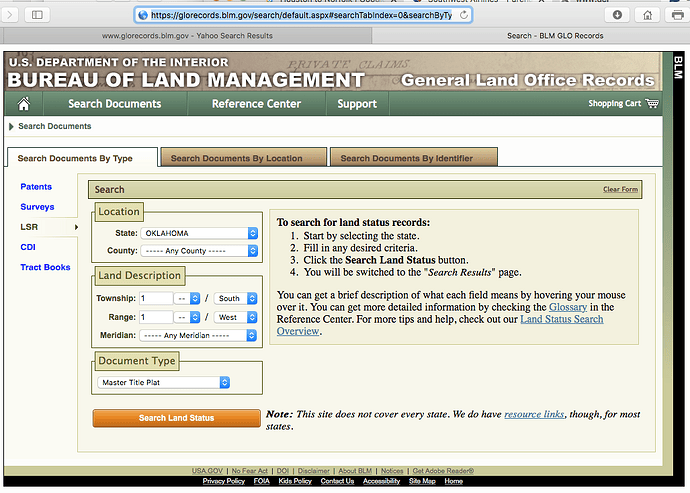
For those of you in OK and in states that have the rectangular survey system, there is a very useful website that will give you the original surveys of your ownership. I use it to get a map of my sections in case there are any features that I need to know about regarding spacing.

Pick Search Documents by Type, LSR on the left, then pick your state, County, Meridian if important, Township and direction, Range and Direction. Then Master Title Plat.
Search - BLM GLO Records]

Pick the image and then you can zoom in and do a screen capture to get your section. I print a copy and attach it to my inside front folder.

Note that the top tier (north) and left tier (west) of most townships do not have regular 640 acre sections. This will be a critical factor to know once you are dealing with division orders. A section may be spaced at “640” or “80”, but not actually be “640”, “80” acres, so be aware!

Get to know the other features of this website. It can be helpful.

1 Like

This topic was automatically closed after 90 days. New replies are no longer allowed.