the landmen making offers to me said they found me because i have existing wells in lea county, who do i call to verify this? im not getting any royalties, just want to find out if i might be entitled to back pay from wells i dont know about
@shawn1 You can observe qualified professionals who provide services to mineral owners in our Mineral Service Provider Directory. These practitioners are often able to provide the specific services that meet your needs.
The Mineral Rights Forum Administration
go to lea county and ask the same question too
who do i need to talk to there?
shawn if you put description of your property like section range and township the forum will let you know if there are wells, good luck!
25s 35e s4 i believe im on the right side of it
The first thing I would do is look at the NM oil map of the area.
I find this map a bit clunky to use but once you find the well, look in Range, Township and Section. When you find a well (dot on map) click on it. You will get all the paperwork NM has on it. Scroll down in the window that opens and investigate the “more info” items. The “scanned file” will tell you lots of stuff but it will also tell you lease names and dates, and well numbers. The other one will give production figures. Looking at the map I see no wells in that Section (4).
Guess: the well in the Section to the north seems new (2019) and productive (90,000 bbls in 2020) is the cause of interest. It is a deep well 12,000 ft vertical. Looks to have a long horizontal component. This well may go under Section 4.
Lea County has a lot of records online, under the clerk’s office. They will make copies for you.
I have found the easiest way to get into Lea County is enter “Eunice NM” in the search block upper left. Mike
1 Like
Here are the wells drilled in that area. Concho Fez Fed wells are in the W/2 (i.e. “left”) of Section 4. Nothing in the E/2, currently.
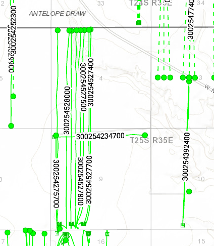
COG does have 10 Fed Fez permits approved that cover the E/2 of Section 4/9. Approved in 2019. They have two Compulsory Pooling Applications in process (case 21538 and 21539).
Not sure where anybody got your name from any wells. There are no producers. Normally the owners would be shown in an NMOCD pooling case but I don’t think those have been made public yet as those hearings just happened. I don’t think you are missing out on any royalties.
But whatever. The COG wells drilled in the W/2 were pretty good. They should drill the ones in the E/2 at some point. Owning in the E/2 of Section 4 isn’t a bad place to be.
1 Like
If you have an interest in those lands, it is a great place to have one.
1 Like
Where can we find well direction maps like the one NMoilboy posted above? I have an active offer in review and this sure would help! Thanks!
That was from DrillingInfo, which isn’t cheap unfortunately. If you want a map of a specific area feel free to let me know.
We have spoken before and I am good for a Sadie’s lunch if you ever get up here. Very small production and no checks all year from Endeavor for those Artesia Fed Com 311, 322, and 62 wells. I’m too impatient to wait for Endeavor relations and just thought I’d ask you. Hope all is good and as always I appreciate your advice. Mike M
Mike, sent you an email to cybermesa acct if that is still active.
If you have access to a map of my mineral interests of SW/4, Section 27, Township 12S Range 38E and NW/4 Section 34, Township 12S, Range 38E, I would be so glad to see where any wells are. I am receiving royalty from Legacy Reserves on Presley 1-34. I haven’t received any on the Trinity-Burris WFU (TABU) since November 2019. Is there any other action in that area?
Hey. Here is a map of your area, see below. All wells shown on the left, San Andres drilling trend shown on the right. The San Andres horizontals drilled right by your acreage (mostly by Manzano in Roswell) are decent, they should make around 250,000 barrels of oil each I’d guess. You’d think if prices improve there might be more drilling as they are shallow and don’t require a huge stimulation (i.e. are fairly cheap).
If you are ambitious call Manzano, ask for the land department, and ask them if they are doing any more drilling in 12s38e anytime soon.
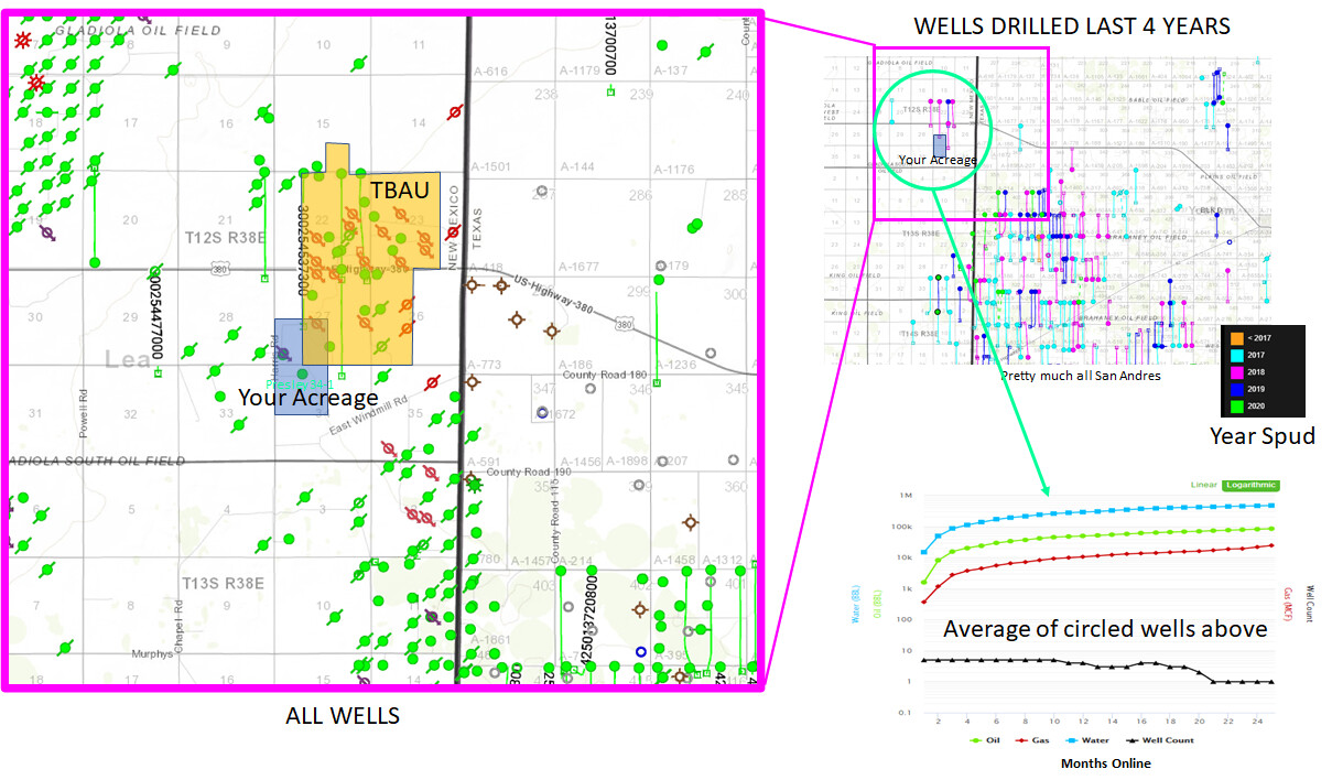
It looks like Armstrong more or less shut in the Trinity Burros Abo Unit in Feb of 2020. Maybe will be back to make 25-30 bopd if prices pick up, maybe not.
Good luck.
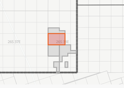
NMoilboy, On a TheDrillings website, I found what appears to be recent leasing activity in the far SE corner of Lea County: 760 acres in Township 26S Range 38E Sections 20, 21, 29. “Ownership and use of this lease is overseen by the Bureau of Land Management’s Carlsbad Field Office under the serial number NMNM 141535. The last action for this lease occurred on September 8, 2020. Information on the lease was last updated on September 30, 2020.” Would you please offer an opinion/analysis on what formation(s) might be of interest in these sections?
AJ11,
Yeah somebody nominated those BLM tracts and they were included in the BLM lease sale from Aug 27, 2020 (map of tracts below). Leases sold for prices ranging from $26 up to $253 per acre if I read the info correctly. Most of it was bought by R&R Royalty out of Corpus which means nada to me.
Boyd and McWilliams was drilling some so-so Wolfcamp wells on the Platform (as opposed to the Basin, where the Wolfcamp is good) about 10 miles to the SE of there. Not sure what else somebody might be chasing. A Fed lease is a 10-yr lease with great terms so it’s not crazy to just pick them up on the uber-cheap as longshots that something unforeseen will happen.
1 Like
Thank you, NMoilboy. Is there a NM GIS map similar to the TX RRC GIS Map Viewer which shows wells–permitted, producing, and plugged? Also, would it be difficult to determine when, if ever, these lands were leased prior to the latest activity? Boyd & McWilliams has some Woodford shale wells in north Winkler County about 5 miles to the east of the NM leases. It seems odd for someone to speculate on leasing in what appears to be undeveloped territory during these times, but I am not in the business. The lease I found had a bonus of $70-some thousand dollars.
That has state and federal leases in it, usually with a popup that could show when the lease originated. You will need to turn on the lease layer.
Yeah, it seems odd to speculate during these times in what appears to be a crappy spot, but a lot of rich folks were speculating on Fed leases in the Delaware before it was cool to do so.
1 Like
Thank you for the link.