I have interest in a well in Harper County (JC Love 3-14H Section 14 Township 26N Range 24W) that I have been receiving royalties on for several years. When my royalty checks no longer included the JC Love 3-14H well and my records showed there was still production, I wrote to the oil operator. Their response to why I wasn’t receiving royalties on the well anymore was because “The JC Love 3-14H and the Zoldoske 5-23H are metered together. All production is for the Zoldoske 5-23H well, there is no production on the JC Love 3-14H since 4/2022.” I am not receiving royalties on the Zoldoske 5-23H well. Can anyone explain how this works? I have never run into “metering” two wells together. Thanks for any insight and assistance. It is so appreciated!
Mind sharing more details on the source of your record? In the field operation, the productions from the wells are allocated data rather than the metered data. Below is a plot showing the discrepancy of the production data from different resources. Hope this helps.
s.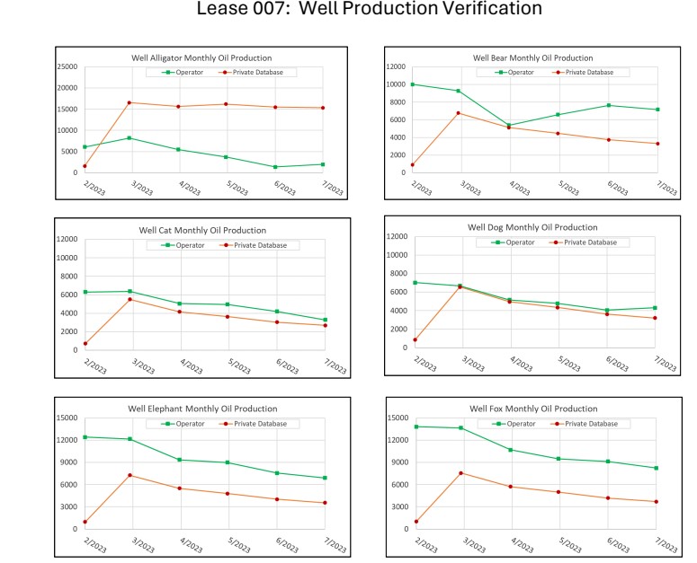
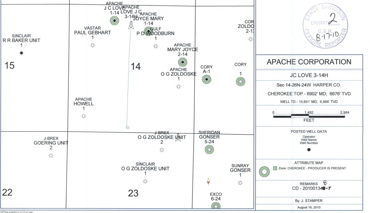
The JC Love 3-14H has a surface location at the far south edge of section 14-26N-24W. It goes north into section 14. Zoldoske 5-23H shares a surface pad and apparently a meter. The Zoldoske 3-23H goes south into section 23. If you do not have any acreage in 23, then you will not get paid on that well. Wells in OK can be metered together if they are on the same pad and are owned by the same operator.
You should still be getting paid on the J.C. Love 4-14H and the J.C. Love 5-14H
If you didn’t get paid for your well JC Love 3-14H, then check the shut-in clause in your lease to see whether you are eligible for any Shut-In payment.
A shut-in clause (or shut-in royalty clause) traditionally allows the lessee to maintain the lease by making shut-in payments on a well capable of producing oil or gas in paying quantities where the oil or gas cannot be marketed, whether due to a lack of pipeline connection or otherwise.
The specific terms and conditions of shut-in payments can vary based on contractual agreements, regulatory frameworks, and industry practices.
The operator provided you with the answer, but they need to be more on the issue of production. You can use a common meter where there is common ownership in the unit or units. If there is not common ownership, there has to be a check meter in the process ahead of the main sales meter. Otherwise, there is no method to properly allocate production. Request the operator provide details on how they are properly metering production and sales to assure proper allocation standards.
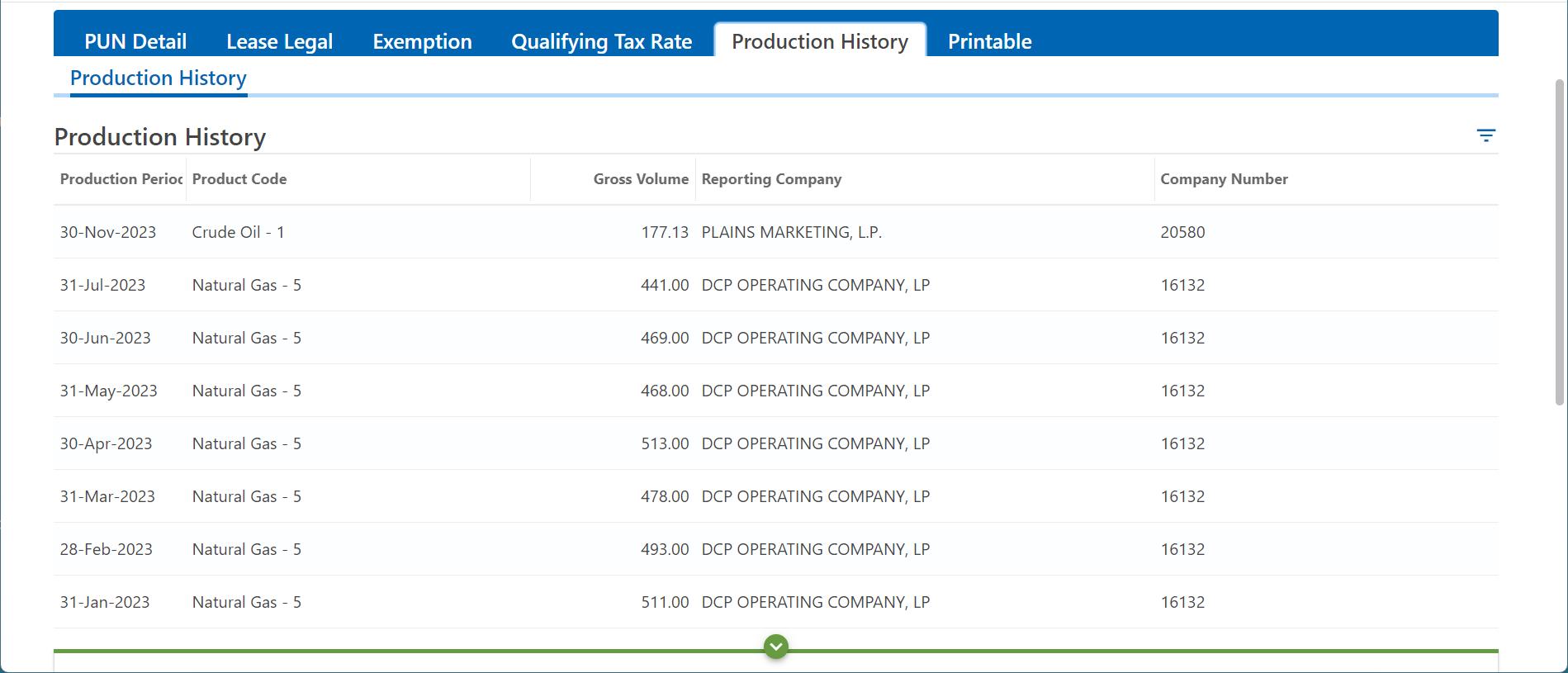
I agree with @James_Garner1 that something is missing from the operator’s explanation to @alwaysmoving. It seems odd that the operator is reporting production on the Love 3-14H to the state (see screenshot below), but telling the royalty owner there hasn’t been anything since April 2022. Also seems odd to set up a “shared” meter with 0% allocated to one and 100% to the other. This usually isn’t called sharing.
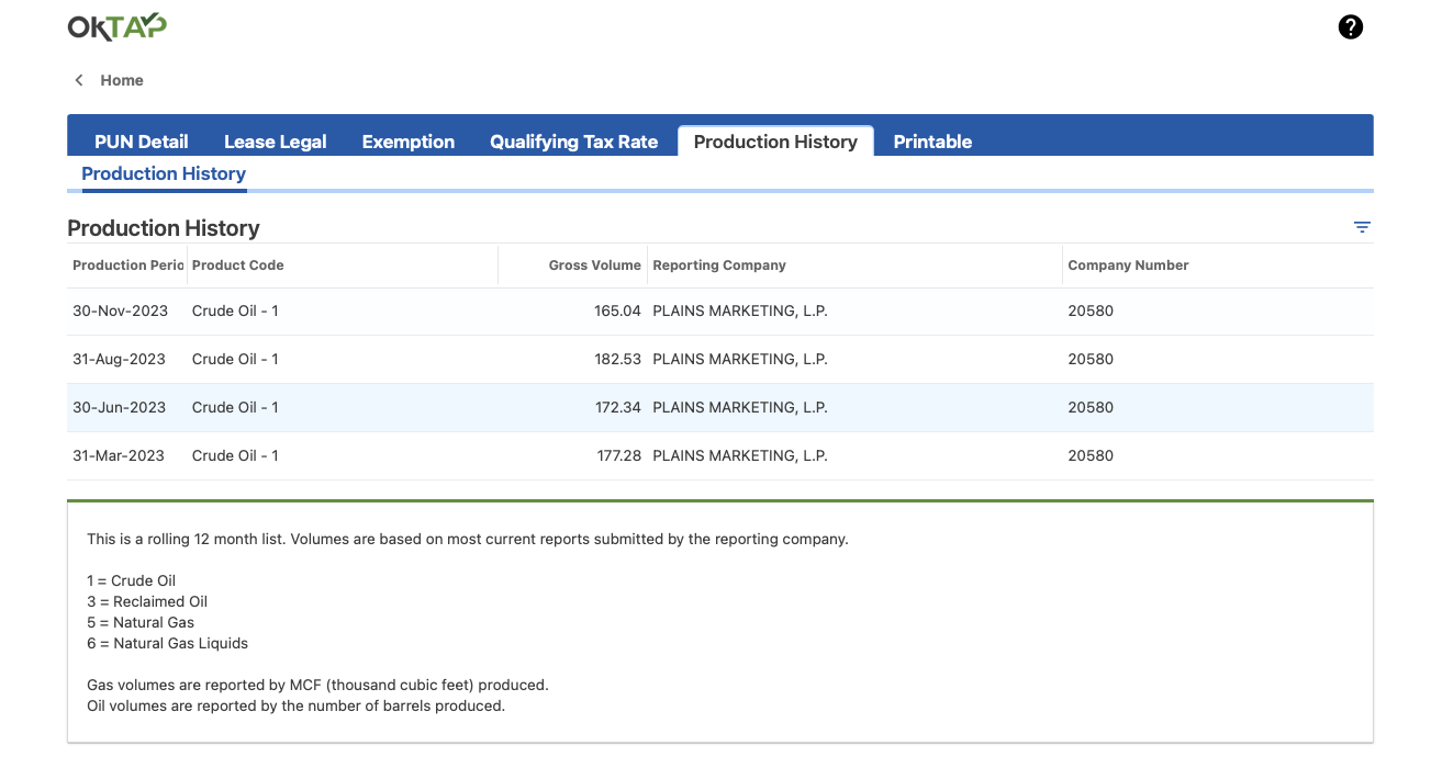
Here is the Zoldoske 5H. it has a separate PUN. Which suggests a different meter to me… but I am not on the ground there. When I have other wells that are on the same meter, they have been under the same PUN and all listed in the name on the OTC.
James & Peter are correct. Wells can’t be on the same meter unless the production stream has the exact same ownership. Wells being on the same pad has nothing to do with it.
You have always been so helpful in getting me through these “stalemates” with the Operator. I clearly don’t have the knowledge or understanding at the level that would allow me to answer them intelligently. Do you have any suggestions on how I should move forward with this to get this figured out?
Which section do you have mineral ownership in?
Harper County, T26N R24W- SW/4 Section 12, NW/4 Section 13, NW/4 Section 14, E/2 NE/4 Section 15, NW/4 NE/4 Section 19, NE/4 NW/4 Section 19, W/2 NW4 (Lot 1 & 2) Section 19
Thank You!
T26N R24W- SW/4 Section 12 - no Zoldoske well. Only State Farmer 1-12, information available on OTC through Oct 2023.
NW/4 Section 13-Zoldoske 1- last productiom 6/1/22. Spaced at 640 acres. Will not have payments for 2023.
Zoldoske A-1 depends upon the spacing.
NW/4 Section 14- Zoldske 1 SW4- depends upon spacing. The Zoldoske 5-23H only has perforations in 23. JC Love 4-14H was still active in 2023. JC Love 1-14, depends upon spacing NW4. O G ZOldoske 1- depends upon spacing. In the SE corner.
E/2 NE/4 Section 15, Baker wells no production.
NW/4 NE/4 Section 19 Already discussed in another topic heading.
NE/4 NW/4 Section 19
W/2 NW4 (Lot 1 & 2) Section 19
This topic was automatically closed after 90 days. New replies are no longer allowed.