Hi, my brother read that new wells will be/ have been built on land we have mineral rights on, but I can’t figure out which wells exactly, by using the ocd oil and gas map.
Our rights are in Eddy county:
Township 25 South, Range 28 East,
Section 11: SENE,
Section 12: SWNW + NWSW
Can anybody give a more definitive list of wells being built / just built/ already built in our interests?
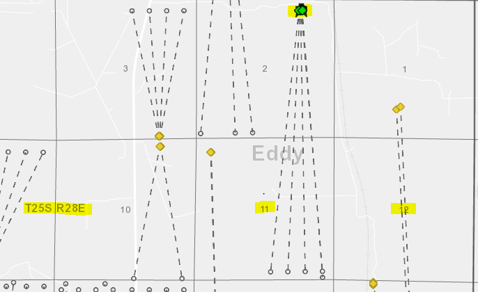
Hi HGW, as you note, no existing or permitted wells appear on the NMOCD map. (Screen shot attached). There are newly permitted
wells in the southern portion of both sections 11 & 12. (Blue dots).
The map wouldn’t necessarily show leasing activity or wells that
are not permitted yet.
Ok, so it looks like 4, maybe 5 wells coming down through the eastern half of 11. I assume those are the wells you mean, and none of the others? Do you know if those are 4 or 5 wells? Thank you!
Pete, if I have gathered correctly, it’s not just the wells IN my sections, but also in the corresponding east/west halves of the sections above and below as well. So wells in the eastern half of section 2 also apply to me, since I own eastern half of 11. That’s what I’ve gathered from my research so far
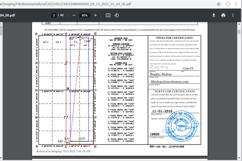
You can pull the proposed unit plat from the NM website usually which will help show what acreage will be HBP’d by those being drilled. Example of one of the wells below.
HGW, yes, wells in nearby areas may have leased areas that overlap with your holdings. Pooling or unitization agreements can also allow you to share in wells that you wouldn’t see at first glance.
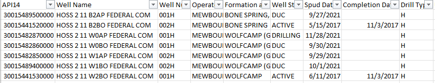
When I do a search for wells whose names contain “hoss 2 11”, owned by mewbourne, I get 7 results, all in 25S-28E… But I’m assuming they are not all in my mineral interests?
30-015-48950
HOSS 2 11 B2AP FEDERAL COM #001H
30-015-44152
HOSS 2 11 B2BO FEDERAL COM #002H
30-015-48287
HOSS 2 11 W0AP FEDERAL COM #001H
30-015-48286
HOSS 2 11 W0BO FEDERAL COM #001H
30-015-48285
HOSS 2 11 W1AP FEDERAL COM #002H
30-015-48940
HOSS 2 11 W1BO FEDERAL COM #002H
30-015-44153
HOSS 2 11 W2BO FEDERAL COM #001H
…
Ok, just to answer my own question, I looked up the location for each well on nm ocd oil and gas map, and they are ALL clustered right next to each other on the upper part of section 2…
So I think there are in fact 7 wells on that lease, in our interests, and not 4?
…
I also found these 2 wells, which also look like they could be in our interests, since they are in eastern part of section 2.
30-015-43946
HOSS 2 B2PA FEDERAL COM #001H
30-015-43947
HOSS 2 W2PA FEDERAL COM #001H
Am I missing something? Are these all wells in our mineral rights?
HGW, as PhillD mentioned, taking a look at the well permit plat is very helpful. This allows you to see if the horizontal portion of the well crosses or involves your owned areas.
Here is one of the maps:
As you can see, the well crosses the north half of section 11
and appears to include the SENE . To see the plat maps
you have to click on the well in the OCD map and then go to the
“link to scanned files” link. The permit document with the map is often in there. The two I looked at appeared include the SENE of
section 11. Hope this clarifies why these wells shown in a different section have portions in your owned areas.
So I will mention that the state is behind on reporting (which is not uncommon) compared to other databases that have some proprietary ways of getting updated info. Not to confuse the situation but many of these wells have already been drilled and are awaiting completion in what is known as DUC status (drilled uncompleted). Today, most operators do what is called a zipper frac or “co-completion” meaning they drill all wells on a pad at one time and then complete them together. It can be nice for a mineral owner because everything comes online at one time (larger checks). Since the wells have already been drilled the easiest thing to do is just reach out to Mewbournes owner relations and let them know you are aware wells have been drilled on/offset your acreage and you would like to see which ones you will be included on. Providing them the well names makes it easy for their land department to tell you. It is usually easier than you trying to find the unit plats because the operator can always file a sundry (change) or order to change the unit size to make it bigger (most common is 640 acres).
Thanks Phil, I actually called and emailed Mewbourne but have not received any response back. That’s why I asked here. But I will write them again with a list of well names to see if that gets them to respond to me. I appreciate all of the info!