I’m new to this topic. My father left me his mineral rights back in 2003. I had no idea I was supposed to go to the county courthouse where they are to be put in my name. We are taking a road trip next week to do just that. How do I find out if I have had the land, where my mineral rights are, drilled on? Please excuse any improper use of verbiage as I am new to all this!! Thank you!
Hello. Welcome to The Mineral Rights Forum! We are all new to this at one time but don’t worry there are many knowledgeable people here from about everywhere. First off, what state are the minerals located in? Every state has a different online system and Texas seems to use a different style of legal description. Also, what is the legal description of the property? An example for Oklahoma would be NE1/4 Section 15 Township 5N Range 3W. Will be needed for the professionals on this forum to give a good answer. That will get a start on this.
Good Luck, Josh
Welcome to the mineral world.
You might want to check in with the courthouse for your county before you hit the road. Many are still shut due to the COVID-19 virus guidelines. They may be answering phones and emails, but the doors are not open. Ask what they require as you may be able to do all of it by mail.
There are many online resources to find out where your minerals are and if they have been drilled. You would have to tell us where they are by State, County and description so we can point you in the right direction.
Thank you! I’m sorry, like I said… I’m new!! Mine are in Texas. I have the tract numbers, where they are located (Wood County), and last night I was able to find at least one area of the 150 acres but I just don’t know how to look up drilling. Thanks for mentioning COVID. I didn’t even think of that. I’ll make a call on Monday to see if they are open yet. Thank you both!
If you post the tract numbers for your minerals over in the Woods County, TX area, you will probably get some direction on how to look up the area on the TX Railroad commission website.
Call the courthouse and ask what documents they need, how they want your letter formatted and what title information you need. If they will accept it by mail, then be sure to mail it by certified mail return receipt requested so you can track it.
The courthouses near me are shut down, so I didn’t want you to make a trip in vain.
My tract numbers are as follows:
FIRST TRACT: Beginning at the SE corner of a 160 acre tract formerly owned by J.P. Byrd; thence North 428-7/10 vrs to the NE corner of a 60 acre tract now owned by E.P. Salmon of which this is a part; thence West 395 vrs. The place beginning, containing 30 acres of land.
SECOND TRACT: Beginning at the SE corner of the hereinbefore described tract; thence West 475 vrs; thence South 355 1/2 to the SBL of the South 60 acre tract now owned by E.P. Salmon; thence East 475 vrs to the SE corner of said 60 acre tract; thence North 355 vrs to the place of beginning, the two tracts herein described being the East one-half of the 120 acres of land deeded by J.W. Gilbert et ux to E.P. Salmon.
I hope someone can help me. ![]()
Thank you!
What you need to post in order for someone to help you pin down the location of your mineral rights is the survey name or abstract number (usually shown as A-XXX). If the description you gave earlier is from a deed, the name of the survey it’s in should be shown there.
No one can help me? Was really hoping to get some answers!!!
Need a survey name or abstract number to help you.
Ok thank you. I only have the above information.
Look more closely through the entire document and see a reference above or below the legal description which tells you about Wood County and will mention a section, survey, etc. How do you know that these tracts are in Wood County as that is not in the descriptions you have cited?
Thank you, that is a great question. Further down in the document it states a deed number for Wood County, Texas. Also, at the top it states, “all of my interest, which consists of an undivided mineral interest in the following lands in Wood County, Texas.”
Okay…I found an abstract number, I think! On my papers the surveyor’s name is incorrect. I found the name is J.B. Chirino and abstract number A-96. I also found out that the rights are in my name at the courthouse! I am just relieved to know that!
Glad you were able to confirm the description and that the mineral rights are in your name.
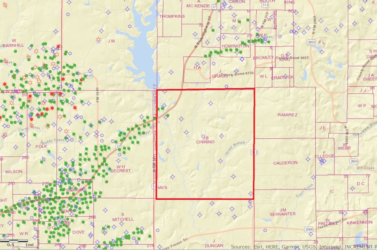
You earlier asked about looking up drilling. Below I’m attaching the current Railroad Commission map of that area with the boundaries of the Chirino Survey A-96 outlined in red. It doesn’t pin down where your specific tracts are in that survey but shows there’s not any recent permitting or drilling activity nearby. The deed records also indicate no new leasing in that survey in the last several years.
On the map all those green dots west of the Chirino Survey were vertical wells drilled from the 1950’s through the '90s but it looks like there has been no production there in recent years. Some pretty good horizontal wells have been drilled more recently in Wood County but they were a considerable distance north or south of your area.
This topic was automatically closed after 90 days. New replies are no longer allowed.