How do I find out what is going on (if anything) with the W J Kennedy survey in Leon County? Thank you!
Cynthia, At least include the State or legal description.
Texas according to her home page.
I'm sorry! I thought this was the forum for Leon County TX only. Leon County, TX. Thank you!
Cynthia,
Here's a link so you can join the Leon County Group.
http://www.mineralrightsforum.com/group/eagle-ford-shale-leon-count...
I checked the RR Commission GIS map and there is nothing going on in the (Kennedy, W J Survey/Abstract #1376/Sec 40) or in the surrounding area at this time. There is some activity in Leon County at this time but just not in your area.
Clint Liles
Thank you!
Back in April 2006 a Mildres Baleja leased and then in June 2011 another lease was recorded at 20% by Roy Simmons IV. Other than that the closest producing well is about a mile away.
Hey, Cynthia -
Sorry to be late to the party, but I've been busy helping other people on The Forum and trying, desperately, to hang on the that pesky little Day Job.
The following link should allow you to download what I was able to discover regarding your mineral interests in Leon County:
http://www.hightail.com/download/bWJweVdvYXlOMUNFQk1UQw
If you have any difficulties, let me know and I'll send the information some other way.
What this information indicates to me is that there are only a handful of wells presently producing in your immediate area. And that only two (2) Permits to Drill have been issued in the last 1,000 days in your immediate area [Both Wells were apparently successfully completed, which is a good indication, but because they are so far away from your lands, I have not included more detailed information on them].
There has, however, been some fairly recent and still active leasing activity in your area, including a lease on your own lands, which indicates to me that there is at least some interest in eventual drilling.
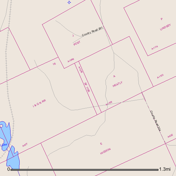
The last two files are regarding the Patent on your lands. Scrap File (SF) lands are lands that were, however inadvertently, "missed" by the original Surveyors when they mapped out the original Land Grants or Patented Lands.
There is a whole lot more to this, but simply explained: Beginning in 1895, as such "Scraps" of land were discovered, they were "Classified" by the Texas General Land Office as "Grazing", "Agricultural", "Mineral" or the like - sometimes a combination of the possible variations.
Fortunately for you, your lands were Classified as Agricultural and, therefore, your original Patentee, W. J. Kennedy, received all of his minerals.
This is not particularly effective information as to your original inquiry, but you might want to save the information for your personal files.
I do not know what your net mineral interest is in all or part of the original 11 acres of the W. J. Kennedy Survey, but the 6/11/2011 Lease from Roy Simmons IV to C&PW Corporation appears to still be under it's original three (3) year Primary Term, with C&PW Corporation having an Option to Extend it for an additional two (2) years beyond that.
If C&PW were to exercise it's Option to Extend it's lease next June (2014), for the additional 2 years, that would be an indication of it's having some intention of including your lands in a well or Unit.
If any Permits to Drill were to be filed including your lands between now and then, that would be even better, but we'll have to wait and see.
There has always been a lot of Drilling activity in Leon County. There are a number of formations, at different depths, that have been found to be quite productive there.
Hope this helps -
Charles
Thank you, Charles! You have explained so much to me! I have a partial interest in that lease. I am trying to learn and you have helped quite a bit! Thank you!
Charles, in looking at the Map of Producing Wells, there is a yellow dot on our survey. Does that mean there is a producing well on our survey land?
Cynthia -
I understand that that can be confusing, but No.
The Base Yellow Dot, with no number, only indicates the center of the Survey that I performed my basic DrillingInfo.com search on, in this case the W. J. Kennedy Survey, Abstract No 1376.
Those Basic Yellow Dots show up in any DrillingInfo search that I compile. I apologize if I did not remember to make my usual effort to cover it over in my final presentation map(s), so as to not confuse anybody.
Any Yellow Dot in any map that I send you that indicates a Well will have a five (5) digit number next to it.
Those five (5) digit numbers are the last five (5) digits of any given Well's American Petroleum Institute Number (API #).
If you will notice in the spreadsheets, there are actually a series of numbers assigned to each well:
"42" = The State of Texas
"161" = Freestone County
"289" = Leon County
The last five (5) digits are the numbers the API assigns to any given physical hole in the ground in any given County or Parish.
They do this for every Well drilled, in every State and every County or Parish in the US.
Hope this helps -
Charles