Finally! Does anyone know why the well data site isn’t working? I’ve tried to open up the form but it doesn’t do anything. For several days I have tried, even old documents from other wells.
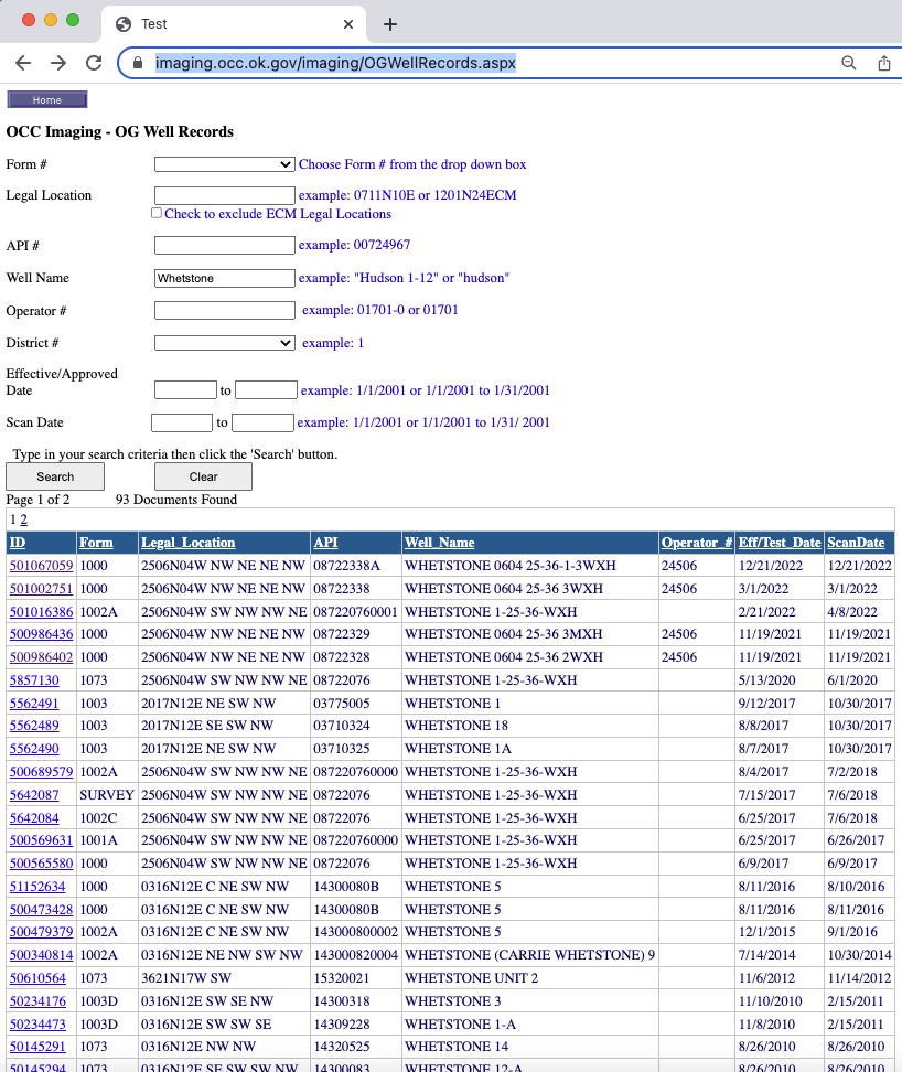
12/21/22 is the scan date. And after one year from the original permit to drill for the well or wells, there’s the form. ![]() And I want to see it…
501067059 New Whetstone
And I want to see it…
501067059 New Whetstone
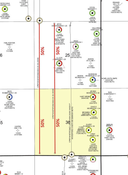
What is the section, township and range? There are several Whetstone wells. The API for this one is 3508722338A- revised permit from the one back in March 2022
Are you looking for this one?
Yes, that is the one. But why can’t I open the form from the well database? Still unclear to me if I’m getting 2 or 3 wells, and that’s fine. I just would like to see one of them get started before I die. So do I understand this correctly, 2 wells in each location that I will share with two other sections? That is 6 wells tied in together. I’m sure there is a different way of describing that, I’m so confused… Would this be called two 1920-acre multiunit wells?
Casillas has dragged this out for over a year, changing their minds a few times, extending the permits, etc. The 2WXH well had a permit in Nov. 2021 that is getting extended. Is this one on the PDF you sent me referring to the 3WXH well?
Casillas is juggling priorities in many sections, so this is just one set of them. There are two Whetstone new wells, #2 and #3. Here is the permit for #2. I sent #3 revised yesterday. They opened just fine from the website which I hit the document ID number in blue- #3 revised is 501057059 and #2 is 500986402. https://imaging.occ.ok.gov/OG/Well%20Records/1DDC7222.pdf Scroll down to page three and you will see the map that shows where #2 is on the far west side of sections 25 & 36. Here is the original permit for #3. https://imaging.occ.ok.gov/OG/Well%20Records/1DDCB1FF.pdf It also has a map on page three and you can see that it will be to the east of #2. Each of the wells is two sections long. The spacing order numbers are listed on the permits. They are at 640 acres. Here is the exhibit from the increased density application so you can see where they are planned to be.
Could you send me the link to the well database? It does not work on my phone or desktop. It used to. I’ve been doing this for years now. When I bring it up from my bookmarks it always says this page has moved and in 3 seconds it takes me to the home site. But it only shows the docs and I can’t open them. Weird.
You may have to update your reading software. If you are using Adobe, make sure you have the most recent version.
Here is the link. Test
Ok, thanks for the new or new to me link. I have been using an old one apparently. Here is a copy and paste version of the one I’ve been using.
Home Well Name/Number Well Name Well Number
API Number API Number
Ex: 35003; 3500300001; 35003000010000 Location County Section Township Range Meridian Quarters
–Select County–
Ex: 29
Ex: 06S
Ex: 13E
Ex: IM
Surface Hole Bottom Hole
Operator Name/Number Operator Name Operator #
This topic was automatically closed after 90 days. New replies are no longer allowed.