Any info 160 acres NW/4 of Section 45, Block 36, Township 5 North, T&P RR Company survey Dawson County Texas any info would be great location any activity
1 Like
Hey there! Welcome to the community. What were you looking to find out? Looks like some activity a year or so ago nearby.
Hello and welcome to the forum!
For the description you gave, your mineral rights would be located in the red square in the following image. I’ve included information on the surrounding wells labeled by oil operator (SM Energy, EOG etc.) and Lease Name. You are very close to EOG leases (and one SM lease) to your west and east. To your south SM Energy has put in multiple drilling permits (Joey Macdonald, Cutter A, Blue Beauty A).
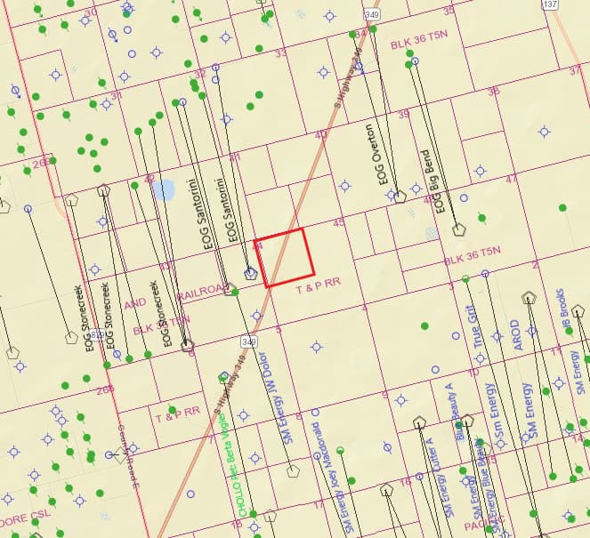
For the currently producing leases in your vicinity you have the following: EOG and one SM Energy leases to the west:
Stonecreek Lease #59181 (produced 386,811 BBLS of oil since March 2021) Stonecreek B Lease #60168 (produced 406,081 BBLS of oil since May 2022) Santorini Lease #55335 (produced 463,015 BBLS of oil since May 2020) (SM Energy) JW Dollor Lease #57705 (produced 61,678 BBLS of oil since Feb 2022)
To the east:
Overton Lease #59180 (produced 212,961 BBLS of oil since May 2021) Big Bend Lease #59006 (produced 3,292 BBLS of oil since July 2021)
South of you are the SM Energy leases (most of which don’t show results yet, but SM Energy is releasing their results for the 3rd quarter of this year on October 30th so may have something then).
AROD Lease #58037 (produced 579,642 BBLS of oil since July 2022) Blue Beauty Lease #56629 (produced 538,278 BBLS of oil since July 2021)
Here is a heatmap from The Pecan Estimate showing your section as well.
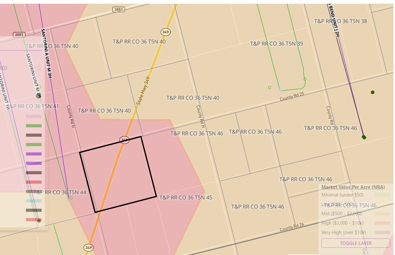
Although the pecanestimate seems like an okay thing to throw out there, it definitely needs some context for most people. The heat maps being posted, specifically the price range legend, are way too broad for any good use. Also, not many people are aware of the difference between $ per NMA vs $ per NRA. That definitely needs to be noted. It may give some vague at best ideas as to prices for purchases of minerals on a NRA basis, but that’s it. Too many variables have an effect on pricing, especially in Dawson County. Not sure where this data gets pulled from anyway, as not many owners or oil companies are posting what they bought/sold minerals for to the public to even build this database. The insight pecanestimate provides is very, very limited in my opinion. Seems more like an ad to get people to “value my minerals!” and then have whatever royalty buying company is behind it be able to get some nibbles on deals or have folks pay for evaluations.
Thanks for your thoughtful response! I cannot speak for the methodology they use nor what accuracy it entails but I do believe that behind this great “information paywall” mineral rights owners find ourselves, any in the ballpark estimate is better than nothing. Hopefully anyone asking questions about their mineral rights will understand to do due diligence. They were asking for help, so I thought I would provide them a possible tool to use, that’s all.
I will say however, as a subscriber of the service, that the bonus payment I actually received was about 65% of what PecanTree estimated I could get. One way it was definitely useful though is in showing how I had interest in wells I didn’t know about. Unfortunately, those wells had since long been plugged but I can imagine how that could help some.
I am not trying to beat their drum as they say. I just believe more information is better than none but caveat emptor always!
Cheers!
PecanEstimate $0.02:
I’ve only used it a couple of times, but quite sure it’s an actual calculation of the value of the minerals on an NRA basis. It’s not some database of mineral offers. It goes something like: Select an area; pull offset data, figure out type curves and number of undrilled wells, space them out over some predicted drill cadence, use some price deck, discount cash flows back at a PUD type of rate, voila… value per NRA.
It’s meant to be generalist, work anywhere in the US. And mostly to be sort of a sanity check. IMO it’s never going to be more exact than actual knowledge of the area. It’s probably less accurate in a completely off-the-wall, limited data high-risk environment like the northern edges of the Dean play in Dawson County. Because there is way too much guessing going on there. By anyone.
But it’s a very pretty cool method/process and they don’t seem to have much interest in monetizing it in the most efficient (devious?) way, which is to just sell it to Pegasus or somebody. So no, I don’t think it’s a phishing line for a mineral buyer.
In terms of the OP. You presumably know you are on the northern edge of the Midland Basin, beyond the extent of the proven Wolfcamp play. People have been playing the Dean formation (just above the WC) in this area. There are 11 or so Dean wells drilled across the lower edge of Section 36 Township 5 North. Including right next to you (in the map Caesura showed, the Santorini M). Those wells are a mixed bag. Half good enough to drill more (initial rates > 10kbo/mo), half are poop. I have no idea why those are the results, but they are. At some point somebody will likely drill two wells in the West half of Section 40/45, or even better for you (as you get pooled with better acreage to the South), in the Northwest quarter of Section 9, the West half of Section 4 (of 36 Township 4 North) and the West half of Section 45. But I doubt anyone is rushing out to do that, since well… half of them are poop. But at some point we are going to run out of good places to drill wells and will drill wells anywhere they might work. Based on offsets, a decent well will make about 100 boe/NRA over its life.
If people don’t know the difference between NRA and NMA, don’t sell your minerals.
I had a lot of caffeine in the past 4 hours.
2 Likes
This topic was automatically closed after 90 days. New replies are no longer allowed.