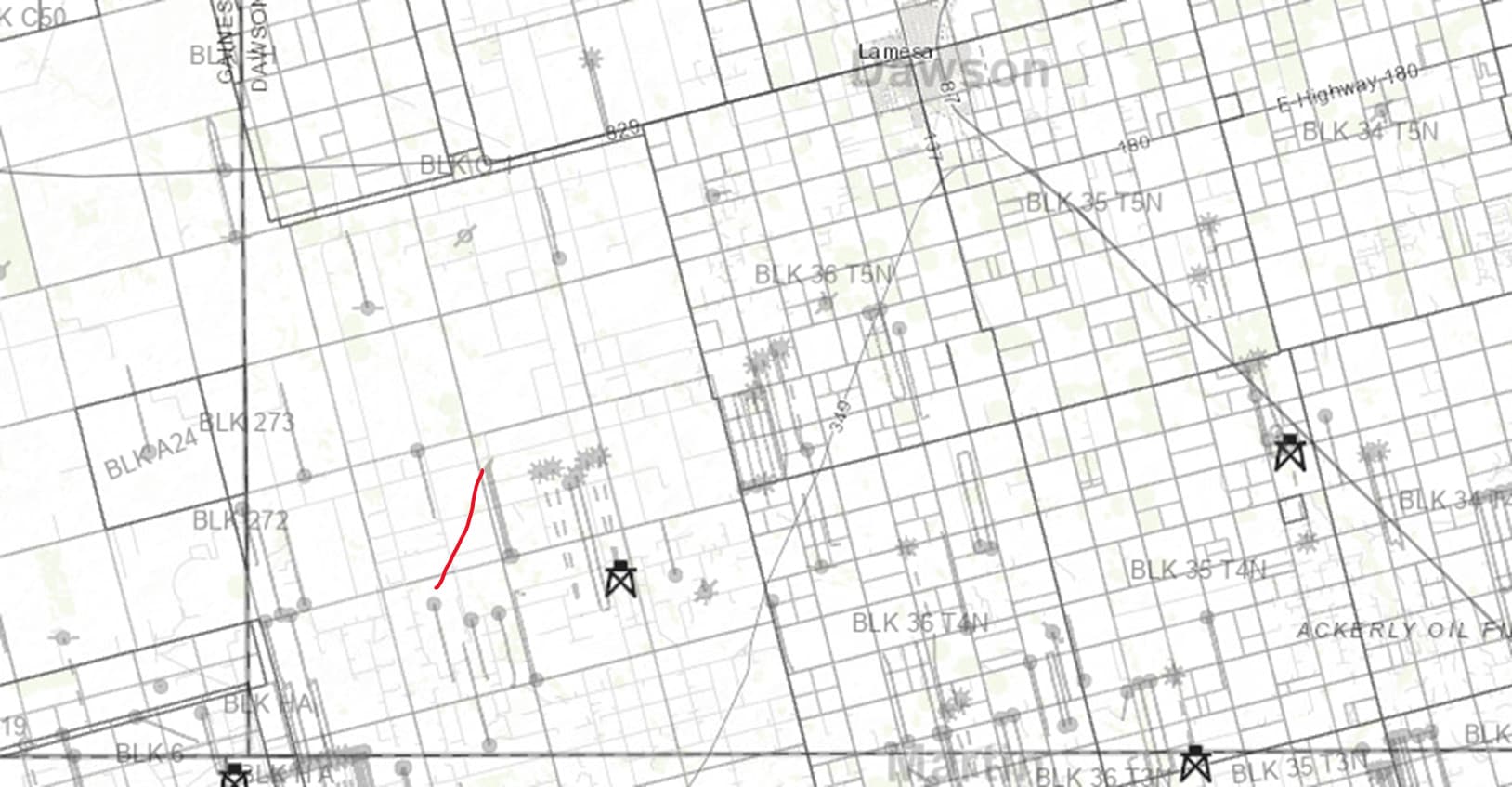
EOG has not applied for a drilling permit in Dawson County in a long time. However, they have recently applied for a 9,000’ horizontal well 14.9 miles SW of Lamesa. The Cozart A Unit U6 #1H is targeting the Spraberry formation. The well will spud in League 266, travel across the eastern part of League 271, and finish in the NW corner of League 270.
It looks like it’s > 15,000’ long. I assume in the Dean. From the odd lateral direction (20 degrees East of North) one would guess they think the minimum stress orientation is orthogonal to that well path.
SW Dawson… Trying to make lemonade I guess.
Does anyone have section numbers instead of league numbers for this well?
There are just leagues, no sections. On a map of southern Dawson it’s the red line. And yes EOG is running that rig in league 267 just to the East of there.
Interesting that there is a drilling rig for EOG in League 267. They permitted several wells there in December 2022 and January 2023, but never drilled them.
Thank you for this info. EOG let almost all their leases (mine included) lapse. It’s wonderful to see activity from them again. Perhaps they have solved the problem of increasing and extending production in their wells. ![]()
Actually, they did drill the Trinity A unit (well M1H) out of League 267 north into 270 (API # 11533867). My wife has minerals in Labors 2-9-12 of 267 and the well has been in pay status since June of 2022. I saw on Mineral IQ last week they had a rig on the Trinity B (same Labors for her). The Trinity A has been a decent producer, no barnburner but certainly worthy of offset. Apparently EOG feels the same.
Now they say there is also a rig in 267 in her Labors 1-10 east of the above, again running north into 270, called Acradia A unit (not “Arcadia” though I suspect that was a misspell on the W-1), 2 wells M1H and M2H.
I have to go to San Angelo fairly soon so I may just run down 349 and cut west on County Road 26 and have a look.
The four permits in League 267 that I was looking at were: Trinity C Unit #M3H Trinity D Unit #M4H Acradia A Unit #M1H Acradia A Unit #M2H
My MineraliQ notice from 10/23 showed the two rigs which drilled the Trinity C and D in mid-September had skidded over and are doing both Acradias as we speak, Independence Rig 305 and the other one not provided… could have just run a rathole rig to set conductor but shows as in progress.
I’m glad I saw this because it now dawns on me we haven’t seen Division Orders on the Trinity B well, so EOG will get an email.
Glad to see that EOG continues to apply for new drilling permits in Dawson County. Two new permits on Santorini lease and four new permits on Bluebonnet wells. As long as they are reviving old expired CGS permits, might as well drill the two Fossilcreek wells in League 269 and the Foxrun well in Leagues 269 & 276.
I have minerals in Labors 2 and 3 in League 270, leased by EOG. Does anyone know, is that new well near my locations?
They also just got drilling permits approved for Panther B and C in Section 38 Block 35 T5N
marmcc63, the EOG Trinity C, Trinity D, and Acradia M1H wells are about 0.6 miles south of your land. The Acradia M2H well is about 0.7 miles away. Not too far away. Keep your fingers crossed!
Fingers crossed! Thanks for the information. I also have minerals in League 275
I think Leagues are divided into smaller units similar to sections called “labors” pronounced lah-BORE (singular) and lah-BORES (plural). The RRC map viewer shows the labors in leagues in Gaines County when one zooms in. Not sure about Dawson County on RRC map viewer.
Leagues and labors are also used in western Dawson County. These terms were used in an archaic system of Spanish land grants. A League is 4,428.4 acres and was considered by the King of Spain to be enough area to raise livestock. A labor is 177.1 acres and was considered to be enough area for a family farm.
2 Likes
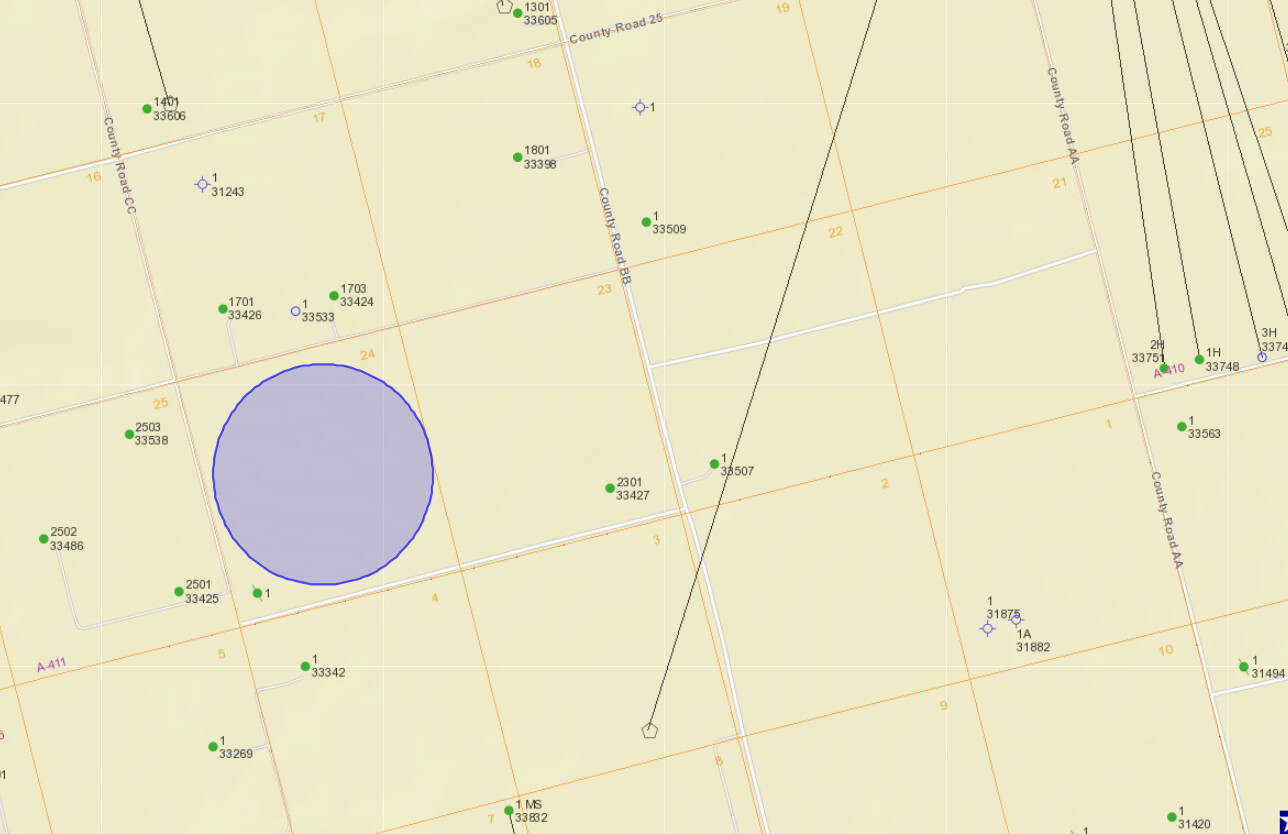
I have mineral rights in 271, Labor 24. From the map, it is not clear if this activity involves Labor 24. How can this be confirmed?
Click on the link and scroll down to the bottom of the drilling permit page and under “Attachments” open and view Cozart Unit A Plat #2 and Plat #3: (Form W-1: Field List).
It appears Labor 24 is not included in that unit, but get other opinions and do more research.
Also look at the RRC map viewer image below on which I have placed a blue circle on what I believe is Labor 24.
This topic was automatically closed after 90 days. New replies are no longer allowed.