I’m trying to learn about an inheritance that has been tied up in court by an interpleader case over the leased interest. I believe the Texas Supreme Court sent the case back to the lower court to finalize it but I haven’t heard anything. However, I’m starting to get interest in acquiring our 15 royalty acres all of a sudden.
The Royalty Lease states:
15 Royalty acres in and under the following sections: All of sections Nos. 2, 8, 10, 14 and 22, Block C-1, Public School Lands, and containing 3200 acres more or less. All situated in Reeves County, Texas.
I have no idea what that means. Any information anyone can provide about the lawsuit, what 15 royalty acres mean or activity and production would be appreciated.
Oh Mike, I hear ya.
I have found the properties I manage at the respective counties CAD web page.
Here’s the link for “Reeves” County…http://esearch.reevescad.org/
The site will give you some free information like Owner and Property Number, and also the current market value and tax value of the land.
There are many web sites that will provide specific information including permit status, and who the current operator is (oil or drilling company). But these web sites do charge a monthly fee.
This message board has some great “seasoned” owners and supporters that are willing to provide help.
I may be just as green as I am far from seasoned.
It sounds like you probably inherited an undivided royalty or mineral interest that came out of the 3200 acres in the sections you listed. If you’ll go up to the spy glass at the top of the page and type in Net Royalty Interest you should find posts that will explain what that is. Sorry I can’t give you any help on the status of the lawsuit you mentioned but expect you can also find that online if you know the docket number or how the case is styled.
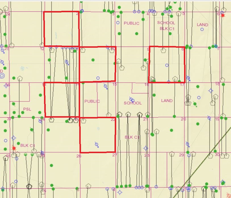
For what it’s worth, below is Texas Railroad Commission’s map with those 5 sections of PSL C-1 you mentioned outlined in red. Obviously it’s an active area with several Patriot Resources (PRI Operating Co.) horizontal wells in production that involve parts of the sections you listed. Some of those started producing as far back as 2013 and Patriot has permits approved for a bunch of other wells there.
If you’ll invest a little time learning how to navigate RRC’s online database you can get a lot of detailed information on the production from those wells, and it’s all free. Here is a link to their site:
I am pretty sure that if these are Public School Lands then the mineral rights are ceded to the public schools, at least that is what I have been led to believe sometime in the past. You may have surface rights and water rights but you need to check out the mineral rights on those properties.
There is a great deal of variance in mineral ownership in the Public School Lands surveys. Some tracts are owned and leased by the State, some are mineral classified where State owns minerals and surface owner leases as agent for State; some are wholly owned by individuals; some have individuals owning the minerals, but the State has reserved an NPRI or set royalty interest. There are tracts outside of the PSL surveys with similar situations. The GLO GIS viewer allows you to get to any particular tract and determine whether or not the State owns minerals or NPRI.