I’ve never figured out how to use the “well browse” function at the OCC site–could someone help me? I’m looking for well names in the N2/SW4 of Section 22-11-11. If company names are listed for that area, that would help too! I feel sheepish admitting this, but I recently found out this property of my mother’s has been “held by production” since 1968, but I don’t know by whom. Most royalty checks include the section/township/range and well names associated with the royalty, and I record all those on a spreadsheet, but some companies don’t give a location or well names with checks. I’m trying to fill in that missing info. Thank you in advance for any help you can provide.
First, go to: Test
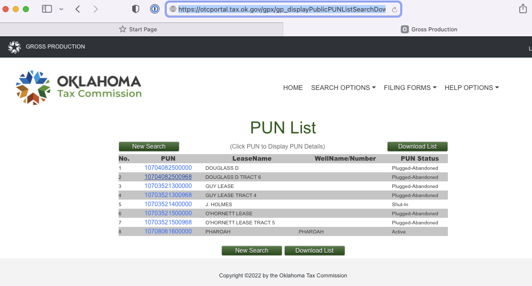
Next, type in 2211N11E into the legal location box. That will bring up all the wells in the section. In the legal location column you can see the rest of legal description, so you can find the ones in the SW 4. You can narrow down your search that way. 1000 is the permit. 1002A is the completion and 1003 is the plug and abandon. 1073 is a change of operator.
You can see which wells are active and which are plugged, The Pharoah is listed as active, but it was drilled in the NE4 and with 80 acre spacing, does not cross into your acreage which is in the N2 SW4.
Thank you Martha! I looked up this property and it appears to have been a good one…back in the 1920s! And there was a little activity up through the 1980s, but not much. I don’t think we’re getting any royalties from it, so I wonder why I got the message a couple of years ago (by a land person) that it was “held by production.”
Ack, how did I forget to put the directional designators after the 11s in my post? And how did you know what they were supposed to be? I was looking at an old letter about the property that didn’t include the N after the first 11 and the E after the second 11, and just forgot about them. I feel pretty stupid.
Pharoah 2 was still online as of Feb 2022, so the landman might have thought it was that one.
I looked up 11N 11W first out of habit, but realized it was over in Grady, so switched to E and it worked. If you have other acreage that you are tracking, also check in the sections contiguous to yours because sometimes the surface locations are in another section and the bottom hole is in your section. For some reason, the OTC tax site tends to work better if you use the bottom hole location (most times) and the well site has the surface location. I use them in tandem when I am looking my wells up.
Good for you for getting organized. It is such a great idea and makes life easier when paperwork comes in.
Thanks for the additional info; I’m more confident about looking up wells now…it was all the blanks they show at those well browse pages that scared me, because I thought you had to enter a lot more info than just the legal land description.
I googled “bottom hole location” and “surface location” and see they pertain to horizontal drilling. Based on your knowledge, what percentage of oil/gas wells being dug today involve horizontal drilling?
Also, I’m confused about your statement “the OTC tax site tends to work better if you use the bottom hole location.” If I’m just entering a legal land description to find out if there’s any well(s) there, how would I “use the bottom hole location”? Maybe you mean that the OTC tax site tends to list horizontal wells by their bottom hole location, whereas the OCC well browse site lists them by surface location?
I know from my years at this board you’re highly knowledgeable about all this, but I’m still learning, and there’s a lot to learn.
On the OCC well records site, less is better. If you know the well name, you can only use it (but “Smith” will turn up a lot of wells). You can pair the name with the location. You can only use the location, but not worry about the rest of the blanks.
In OK, approximately 95% of the new drilling is horizontal. That came from a talk by an OCC official about a year ago. Could be a bit different now, but still very high.
On the OTC tax site, I just put the bottom hole location in the “location” boxes at the bottom. You can find it on the permit from the OCC site. You can use the surface, but if you don’t find the well, then try the bottom. Seems to work better.