I have mineral rights to a place in Neches, Texas (Anderson County). I have moved and LOST all my paperwork that goes with this. I am trying to get all my affairs in order and this mineral right place is driving me insane. It is on ACR 353 (1st or second house) - I can’t remember which one we owned all those years ago. How can I find out who has the drilling rig on that road and see what is going on? I live in another state now and am not able to travel back to Texas. Thank you!
Hard to tell from what you described but if you are talking about ACR 353 running south from Highway 79 and crossing ACR 346 I don’t see any drilling going on there. Are you saying somebody has a rig up on 353 now?
The only thing I see in the Anderson County deed records in the name of Casper that’s in that general area are three oil leases that were signed with Graem Resources in 2014, all in the John C. Ogden Survey, A-594. Does that sound familiar?
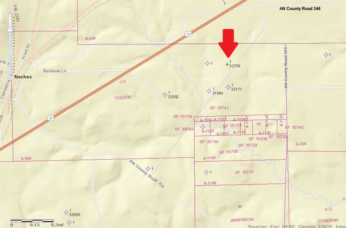
Below is the Railroad Commission’s map of that area. I put an arrow pointing to the only well it appears has been drilled in that area in the last 5 years. In 2014 EOG Resources took over all the leases that Graem Resources and several other companies had originally taken in Anderson County. They drilled a vertical test well called the Mathis that is marked with the red arrow, but EOG pulled out of the whole county before it was completed. In 2017 they transferred that Mathis well to Brooks Petroleum but apparently it has never been put into production.
1 Like
Cypress Operating has drilled two wells in the area, the Roberts #1, 2.4 miles southwest of Frankston which is wet and the Hamil Foundation which was spudded in February 3 and that is probably the rig you saw. I heard that the Roberts well was only producing a few barrels a day.
Hi John, those two wells you mentioned were west of Highway 155 near Frankston. I think Melissa was asking about something that would be east of Highway 79 closer to Neches. Maybe she can pin that down better by telling us which survey she is talking about.
Been a long time since we’ve talked about it but do you know if Brooks did anything with that old EOG Mathis well after they took it over?
You mentioned the John Ogden survey in replying to Miss Casper and it joins the Wm. Bledsoe survey which we own about three miles west of Neches but I’m not familiar with the county road numbers in our area. And we haven’t seen any sign of drilling in our area. My oldest grandson has a surveying degree from UT Tyler and he was on the surveying team on the two Cypress wells near Frankston. We sold our two sons our share of the 640-acre survey about 5 years ago with 100% financing and three weeks ago we deeded the mortgages to them and their sister so the two boys are making one third of their payment to each other and one third to their sister and keeping one third in their hip pocket. My sister and her husband still own 66 acres in the survey which will be bought by our youngest son one of these days. I have heard of some shipments of oil from the Mathis well in years past but I haven’t been aware of any lately. I’ll inquire the next time I’m in the Neches store. I’ll also ask about a drilling rig on CR 353.
1 Like
My husband said he can’t remember who he and his sisters talked to. But he thinks it was around 2014. I have added a photo of Google map of the house that his father owned at one point, but still have the mineral right to the property. When his parents had the house there was only one house so not sure which one was the right one, but you can see behind the houses they have a spot for a well.
Melissa, the Google map you mentioned didn’t come through with your post. Do you have any kind of legal description of the property, like the survey name?
The names of the Caspers who signed those 2014 leases I found in the deed records were Joey Ray, Connie, and Ray Casper. All three of those leases covered the same three tracts in the John C. Ogden Survey, 20.168 acres, 2.46 and 0.032 acres. Is that related to what you are looking for?
1 Like
Thanks John. Appreciate knowing if you learn anything about the Mathis at the store.
I’m figuring whatever EOG was seeing there hasn’t gone away and should get going again someday but a barrel of crude will probably have to sell for a lot more than $60 before it does.
1 Like
YES!!! The Ray Casper is actually my husband named JAY. But the way he signs things looks like an R. Joey passed a few years ago and we are trying to get my husband’s part taken care of since we moved to a new state. Thank you for all the info you have given us. It is truly appreciated.
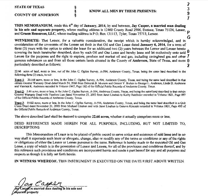
If it helps here is what the lease memo looks like that is recorded in the Anderson County deed records. It includes a legal description of the three tracts. You should be able to pull up a copy at the Anderson County Clerk’s website Welcome to Vanguard Anderson County, TX Search
It was dated 1/6/2014 and recorded in Volume 2397 Page 702.
1 Like
Thank you very much.
Hi Dusty1…
Brooks was never able to do anything with the Autry or Mathis wells. Both have been plugged and abandoned, I believe.
1 Like
Thanks Alan. Hope we’ll have something worth discussing again down the road.
I’m thinking Brooks didn’t have very big plans or much money they were willing to invest when they took them over from EOG. Since horizontals never were added, there is no way to know what their potential might have been or where they were in the overall play EOG was looking at. I’m guessing somewhere on the flanks.
1 Like
The last I heard was that they were talking about tubing on Mathis property.