Hello,
I have minerals in Panola Texas. The problem is my lease does not tell me where in Panola? I only know it is in John Harris Survey. I do have a letter from my Landman which says Powder Mountain Extension Area. Does this tell anyone anything? I don't know that area at all being from California.
Where do I find if my drilling site to see if it is being drilled? It is supposed to be.
I would really appreciate answer from someone. Thank you. Cyndy
Cyndy,
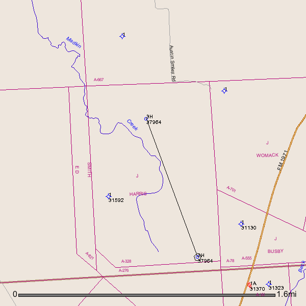
I did a search and found that you have a well that was drilled in May 2013 on your minerals in Abstract # 328--Panola County, Texas. The API(American Petroleum Industry)# is 365-37964. I am including a map of your A-328 and a link to the drilling permit. I could find no completion report on Texas Railroad Commission website. Panola County is a good county in Texas to have minerals. A lot of production of oil and gas.
http://webapps2.rrc.state.tx.us/EWA/drillingPermitDetailAction.do?m...
Clint Liles
Cyndy -
The link below will allow you to download what information I could find on your well on DrillingInfo.com:
| http://www.hightail.com/download/elNLakluTWNubHh1a3NUQw |
It looks like they finished drilling the well back in August but have not yet attempted to complete it or they may just be behind on their paperwork. No production has been reported.
I have included a map and listing of the 27 producing wells in the general area. Only one of them is very impressive and none of them presently produce very much. There are an additional 142 wells not shown or listed that have been drilled over time in the area shown, but they were either dry holes or are no longer producing.
The permit map and it's list of Lessors may help you identify your specific lands.
Hope this helps -
Charles
