I’ve read the mineral rights guide and I’m frustrated at the lack of clarification of what’s considered actual “spacing unit” for multi-unit horizontal wells. The information provided doesn’t explicitly state whether the “total acres” refer to the sum of all spacing units or just the owner’s specific spacing unit tract location. Do I calculate my DOI off of the spacing unit tract I am in or ALL spacing units acres that are included in the well?
Welcome to the forum.
It can be a bit complicated. What state are you in? It makes a difference.
Oklahoma, I checked the final multi-unit spacing order and see my percentage allocated to my section but there are other sections in the multi-unit horizontal well. Do I include those spacing orders/acreage as well or just my section’s total acreage?
Let’s say you own 40 mineral acres in a 1280 unit leased at 3/16ths.
40.00 (net acres) / 1280.00 (unit size) = 0.03125% interest
40.00 (net acres) x 0.1875 (lease royalty) / 1280.00 (unit size) = 0.00586% NRI
If your section isn’t 100% allocated, just use the allocation values, so say it’s 45%:
0.45 (allocation value) x 40.00 (net acres) x 0.1875 (lease royalty) / 1280.00 (unit size) = 0.00264% NRI
Admin: Is precious pending reply going to get approved?
Admin: I guess links aren’t allowed so reposting without links?
I understand the calculation. Can you tell me, in a multi-unit well scenario, is the 1280 coming from your section’s spacing order or all sections’ spacing orders added together? The guidebook does not specify what spacing orders are included in the total acreage calculation.
SP: Your DOI is calculated by your acreage in the unit where your mineral are. You can get 2 scenarios.
#1- Section 1 & 12 have been spaced as a 1280 acre unit. You own 5.00 acres in Section 1. Your calculation is 5/1280 times your royalty no matter where the well is in the spaced unit.
#2- Section 1 is spaced 640 acres and Section 12 is spaced 640 acres. You own 5.00 acres in Section 1. A multi-section unit is developed with a horizontal well that has 65% of its perforations in Section 12 and 35% of its perforations in Section 1. Your calculation is 5/640 times 35% times your royalty percentage.
And to Bob77 above: Just a correction on your calculations. It is not 0.00586%, but either 0.586% or just 0.00586. Your figure of 0.00586% would be a decimal of 0.0000586. The same with your second scenario.
SafetyPin, I hope this helps.
If you give the section, township and range, then we can walk you through the spacing. 1280 would be very rare in OK. Each well has its own spacing, usually 640 in OK. But to give an exact answer, we need the S-T-R. The sections along the northern tier and western tier of a township are not usually exactly 640 acres, so you have to account for the slight difference.
I am getting various answers for this calculation. Is this written in policy and if so what is the statute so I can look it up?
Todd, you are correct, sorry for the error. The equations are right and used for all WI/MI title opinions in the USA that I’ve seen, not sure why I added the % at the end.
Safety pin, I’m not sure what you mean by the guidebook? Or what statute you are looking for? 640 or 1280 acre spacing units come from the apps/orders filed, it’s impossible to get blanket coverage advice. You have to look up your spacing units and poolings to see how your section is spaced and what the allocations are for the multi-unit horizontals.
1 Like
As with M-Barnes, provide your location and we will try to get you an answer you are looking for.
Section 6, Township 8 South, Range 2 East
Spacing Order 202102803 Order 723342 by XTO establishes a 640 ac spacing unit for the following horizons. Caney Ext order 692743, Woodford, ext order 692743, Sylvan New spacing.
201202803 order 723342 Spacing .pdf (287.2 KB)
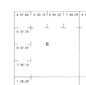
HOWEVER, section 6 is an irregular section due to the curvature of the earth. So you have to search the Bureau of Land Management patent records to get the actual survey and acres.
Note that there is a river and the northern tier and western tier of sections have irregular lots around the edges. You are in section six, so you have seven lots to account for. Your actual spacing is 632.15 acres,
The equation is then: net acres/actual spacing acres x royalty x % perforations in your section.
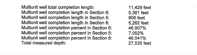
Are you in the Peggy well? It covers sections 8, 5 and 6. You should have been sent the splits for the final survey that says what % perforations are in section 6. Case 202102805 Order 734300
You have the royalty from your lease. If you don’t know your net acres, you may need to ask the division order analyst.
Each well has its own spacing cases and most sections are 640, but not all, so the math has to be done for each well.
The information you are asking can be found in CD#202102805, Order #734300, dated 5-12-23. The XTO Peggy 1-6H5X8 well traverses Sections 5, 6 & 8-8S-2E. Section 5 = 640.85 gross acres, gets 7.052% of production. Section 6 = 628.37 gross acres, gets 46.907% of production. Section 8 = 640.00 gross acres, gets 46.041% of production.
Without knowing your net mineral acres or your lease royalty, I can’t calculate your net revenue interest. But let’s use this example of 5.00 acres @ 3/16ths. You can change those numbers to calculate your interest: 5/628.37 = 0.0079583 x 0.1875 = 0.0014921 x 0.46907 = 0.0006998 net revenue interest.
Hope this helps. Todd M. Baker
Thank you. I appreciate the help!
This topic was automatically closed after 90 days. New replies are no longer allowed.