Hi all. I’m not sure if this is the correct place to post this but here goes. My brother and I have inherited all mineral rights to several parcels of land in Montana. We live in different states. A few are currently in production which we get royalty checks for. We have a company interested in purchasing them but we don’t know how to get a valuation for them. Any help would be quite appreciated.
We don’t own the surface and we don’t know the quantity of the acreage. We are also looking for help on how to figure out the quantity of acreage.
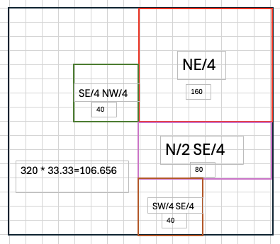
@lmsnipes777, you can get an approximate acreage by the standard sizes of your description:
NE/4 = 160 acres,
SE/4 NW/4 = 40 acres,
N/2 SE/4 = 80 acres,
SW/4 SE/4 = 40 acres,
For a total of 320 surface or gross acres.
Assuming the 33.33% is your mineral ownership percentage then this would give you 106.7 mineral acres.
With the Township & Range you can look up more exact acreages for that Section 11, but the total isn’t going to vary by much.
You can check the Montana Oil & Gas Information site MontanaOG for any existing activity in your section.
This is incredibly helpful. Can you tell me how you got the numbers? I have about 47 more descriptions just like that and need to translate. Thank you so much. Truly.
@lmsnipes777, a standard PLSS section is 640 acres, so a quarter section like NE/4 is 160 acres, and a quarter-quarter section like NW/4 NE/4 is 40 acres and so on. You can look up PLSS (Public Land Survey System) to get more complete info. Not all sections are standard as some are correction sections, or are special due to lakes or rivers or state boundaries, etc. Usually the difference is small, but in some cases it is significant. Many GIS maps will show the sections and subsections and this can be helpful in seeing if the section is standard or not.
When you have PLS descriptions (section, township and range), I find it helpful to read from right to left between the punctuation marks.
NE/4 is easy. You may have 33.33% of approximately 160 acres.
SE/4 NW4. Start with the NW4 which is approximately 160 acres, but you only have the SE/4 which is 40 acres and you may have 33.33% of it. (They should have had a space between the two portions of the description for easier reading.)
N/2 SE/4. Start with the SE/4 which is approximately 160 acres, but you have the N/2 which is 80 acres and only 33.33% of it.
SE/4 SE/4. Start with the SE/4 which is 160 acres and the SW/4 which is 40 acres and only 33.33%.
A picture always helps.