I too have been watching that area but I have noticed every well bore seems to be in a Northwest to Southeast direction and I am thinking maybe Comstock might come from the pad to the right of that survey and drill a 3rd well. It would certainly be in a different direction than all the others but could have a long Southwest lateral into the HF Trahin survey. No filings or permits to date but Cactus 147 rig has been on the Kretzschmar Unit pad for 138 days now. It could pass between or under the 2 Pickens lakes Martha has mentioned.
1 Like
Wells are generally drilled in the direction that gives the most exposure to the optimal fracture gradient of the reservoir. They like to be at a perpendicular angle to get the most drainage into the wellbore. If you are parallel to the fractures, you get sub-optimal drainage as you miss many of the tiny fractures.
2 Likes
Thanks everyone for responding. Super informative. A couple of more questions. Will a search of county real estate records be a source to see if there is a lease(s) in the Trahin survey, or is there a simpler way or source? Also, how does one prevent a company from drilling beneath a property and potentially harm (or profit) from the available minerals, if any?
Mineral rights are dominant over surface rights (unless the mineral rights and surface rights have not been severed.) So a surface owner cannot generally prevent a company from drilling under them. The mineral lease does have some protections for the surface owner.
1 Like
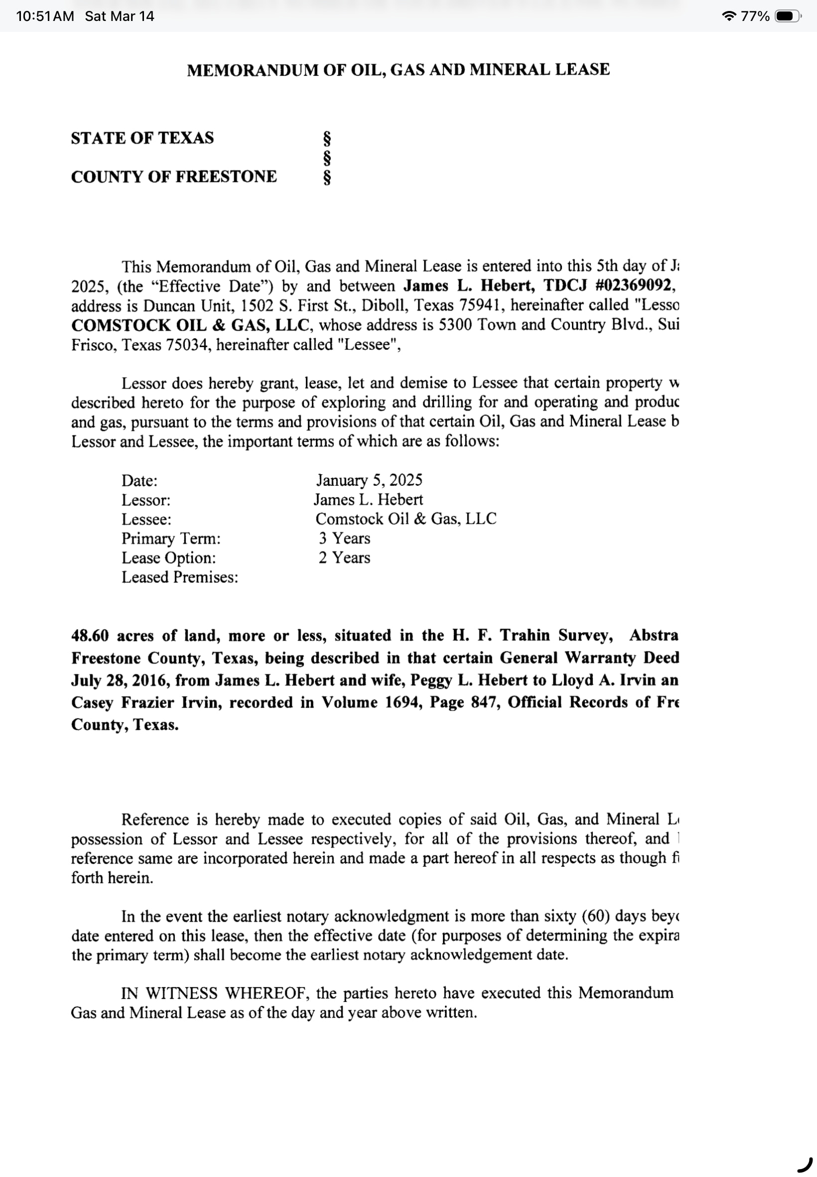
Since the beginning of 2023, there have been 15 leases written that include acreage in the HF Trahin A-797 Survey:
Thorp Petroleum: 682 acres
Vanna Production: 170 acres
Comstock: 49 acres
Surprise Valley: More than 382 acres
1 Like
Again, thank you all for your responses. Great responses. Looking forward to learning more from you all.
Alan, can you check on Enverus again and see if you can determine if either of these wells are completed yet? Cactus 147 has been on site for 145 days now. They are 34873 and 34874. Thanks, Welldatabase had a couple of uploads this week but don’t tell me much.
Enverus shows 874 as DUC and 873 as drilling.
Thank you. Does this seem like an extra long time to have a rig on site? Sure wish I could get timely info for them.
These wells generally take two months to drill, so four months for two wells seems normal.
Ok, at least they won’t have to do any coring on the second one which delayed completion of the first one while the geologists examined samples.
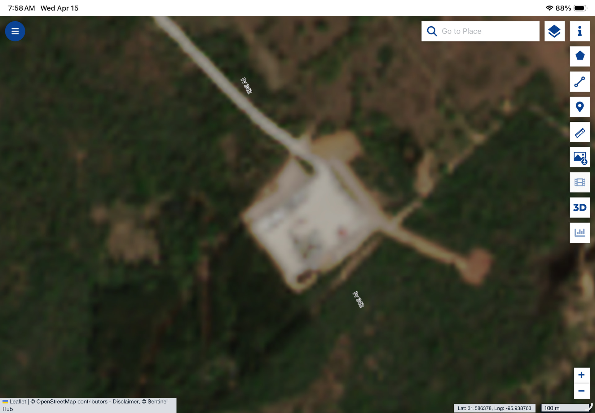
I’m over in Freestone County watching the Kretzschmar PP 1H and PBH 1H wells.
Quick question — have you seen well database trajectories come through with really erratic / zig-zag bore paths during drilling?
PP is showing a strange path right now, but PBH looks clean and straight, so I’m assuming it’s just interim survey data or grid vs ground corrections being applied.
Also — any chatter on timing between drilling and frac crews moving in lately in this area? We’ve had a rig on pad since late October and things have gone quiet.
Appreciate any insight.
Looks like Comstock ran into difficulties drilling the PP well. I asked a knowledgeable person about the directional survey data, and he indicated Comstock had to sidetrack twice to get to total depth. Could have lost equipment downhole or encountered other problems.
Rig is now drilling the PBH well after spending 137 days (October 26 through March 11) drilling the PP well.
I would keep in mind this deep exploration stuff where they are going down to 17,000 19,000 20,000+ feet, is new territory. I think Mitsui may reroute some of these initial wells if they are not landing exactly where they want them to. I think they may have done this with the Baker well.
Thank you Alan, I haven’t been able to visit the site since March 1st and there has been no satellite view since March 31st do I have been in a blind position. I appreciate all the info you are able to gather but see that this thread will close in a few days so I will start another one then. Here is a view of the last satellite pass and you can see the short pipeline construction so they intend to complete the 2 wells. Can’t imagine how much they must have spent keeping Cactus 147 there 5 months!
@Alan_Herrington as an old hand engineer, I sure appreciate the detail and specificity you’ve offered here. I’m about to dig into the conversation posted thus far. I’ll offer this - all thoughtful operators are enfolding some degree of “science” into each well drilled, in order to further their understanding of the play they are in. Science being defined as “we’re doing this in order to learn something”. So, thanks again for an engaging question.
Depending on weather we may try and visit the Kretzschmar wells again Sunday and check up on Cactus 147 and the PBH progress. This thread closes in 2 more days so by the time I get that done it will be closed. I’ll make a new one with my report and photos, maybe I can get the pad manager to shed some more light on the difficulties they had with PP and the 2 sidetracks. Thanks to all who have contributed and I hope the Lipsey wells get tied in soon.
1 Like
This topic was automatically closed after 90 days. New replies are no longer allowed.