My father just found out that he has been an heir to some wells that have been active since 1932 that he had no idea existed, the sections are in Reeves County in Block C-1. How do we find out how many wells/pipelines/tanks/saltwater disposals etc. have been/are on the properties? My father is not an inquisitive man because he feels that if he asks too many questions he will lose the deal, so I don’t know. Help if you can?
@Pat_Lacy please formulate your specific question/s in order to receive input that will be useful for you.
How do we find out how many wells/pipelines/tanks/saltwater disposals etc. have been/are on the properties?
Pat, You need the Section numbers as well as the block then someone on this forum can help you.
Welcome to the forum! Are you sure you/your family still has claim to the minerals? In North Dakota, for instance, the mineral rights owner must file a Statement of Claim at least once every 20 years with the County Register of Deeds, unless there is a lease in force. If neither of these has occurred, the surface owner can file a quit claim and assume ownership of the mineral beneath their surface land. There has to be a “due diligence” search for the mineral owner(s) of record, however there have been some unscrupulous ways minerals have been taken without the knowledge of the original mineral owner(s), especially when they are as old as yours over several generations. You might begin by contacting the County Register of Deeds to see who is listed as the current mineral owner(s).
1 Like
Pat, I don’t think the issue Paul mentioned above related to North Dakota will be a problem for you in Texas. But it does make a difference whether your father inherited a royalty interest, a mineral interest, or also an interest in the surface.
For example, if he only owns royalty or mineral interest then the pipelines or salt water disposal wells that are in those sections won’t matter since they only relate to the surface ownership.
The basic information you need should be in the Railroad Commission’s records. You said the production goes back to the 30’s, but when did your father inherit the interest? If you need to research all the way to the 1930’s it may require a trip to RRC’s office in Austin, or at least talking to their records staff there, but from the 1980’s forward you should be able to see it online. Post the legal descriptions, including the survey abstract numbers if you can find them, and someone can help you learn how to tap into RRC’s site.
1 Like
We had a land man get in touch with us about a month ago and has buyers interested in 50% of his share. Dad agreed, signed the paperwork, and we began to get evidence proving dad is an only child. The block is C-1 Section LS 2, 8, 10, 14, and 22. It’s an interest of 10/3200 non-participating floating interest (whatever that means).
It is probably a non-participating royalty interest (NPRI). That means you get 10/3200 of the royalty for any leases that have been signed by the mineral owners & that you don’t have to sign anything initially. Unfortunately any money that the oil company may have put aside because they couldn’t find your father escheats to the State of Texas, so there is probably a big chunk of money waiting for you. A check of the Reeves County tax rolls shows a W H Lacy owns some small interests in Sections 10 & 11, so you should contact PRI Operating. Good Luck!
Make sure your dad claims any funds held by the State of Texas treasurer before you sell or he will lose them.
1 Like
Pat
Based on the location information you’ve posted and what Ben3 told you above, I think you definitely don’t want to be signing, or making any sort of commitments regarding your dad’s mineral interest, until you have all the facts.
A quick check of the Texas Railroad Commission’s online records indicate those five Sections of Public School Land (PSL) Block C-1 that you listed are included in units that currently have 13 or more horizontal wells producing plus at least two more permitted or currently being drilled. All of those wells are operated by PRI Operating (Patriot Resources). If you haven’t already contacted them I’d start by getting in touch with their Owner Relations section http://www.patriot-resources.com/contact/
Then I’d get familiar with the RRC’s website. Here is a link to their maps and training videos on how to use them. https://www.rrc.state.tx.us/about-us/resource-center/research/gis-viewers/
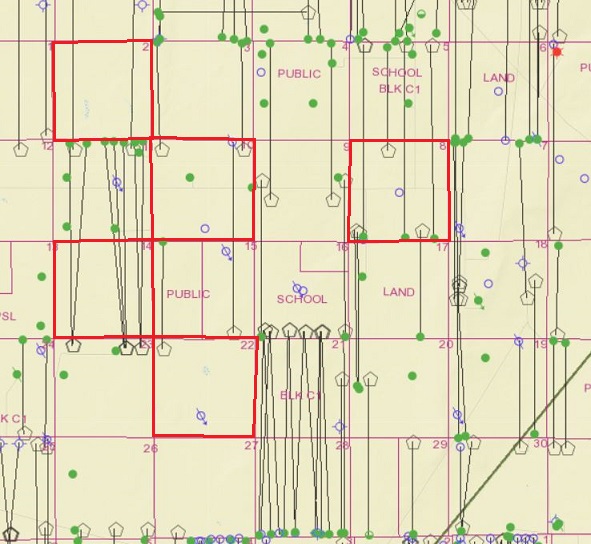
To give you an idea of the kind of information you can find there, below is the part of RRC’s interactive Reeves County map showing PSL Block C-1. I’ve outlined the five Sections you listed in red. Since Section 14 appears to have the largest number of wells I’m also including a link to the plat PRI filed with the drilling permit for the first well they drilled but also shows the locations of the six others they have now completed. That plat for the PRI Viper 14N33 #11H shows the unit covers two full Sections, 11 and 14.
Spend some time exploring RRC’s site and I think you’ll be surprised how quickly you can learn enough to get lots of detail on that area. Locate the wells on their map you are interested in and you’ll then have access to their unit plats, completion test information and production reports.
1 Like
This topic was automatically closed after 90 days. New replies are no longer allowed.