I am trying to get a map of our section/block in Wilbarger County, Texas. How do I obtain that?
Moved this over to Wilbarger County, TX for you. One of the folks in that area can show you how to use the Railroad Commission database.
Hello Rocky. If you can give me the Section, Block and/or Abstract number I can provide you with a map.
Clint Liles
Hi Clint,
Thanks for getting back to me. Most appreciated.
Our property is indicated as;
112.62 Acre Cased West Half of the called North 230 acres of Section 35, Block 12, H&TC RR CO Survey, Wilbarger County, Texas.
Hope that is enough to go on.
Regards,
Rocky Nelson
Sorry Clint,
I also find reference of the land described as;
115-3/4 acres of land out of the North 399.6 acres of Survey No. 35 in Block No. 12 of the H&TC Ry, Co. in Wilbarger County, Texas.
Hope they are relatively the same.
Regards,
Rocky
Tuesday/12-11-2018/2:20 PM
Rocky… At this time I am in a deer blind at my ranch in Western Wilbarger County (southeast of Farmers Valley). It may be 9-10 o’clock tonight before I get back to my laptop but I will send you a map before midnight.
Clint Liles
Perhaps A-167, H&TC RR, Block 12, Section 35??
Thanks Richard.
Clint Liles
Hello Rocky. Your minerals are located North of Pease River and just West of US Highway 283. To the East of highway US 283 is the McDuff 2H that Anschutz drilled in 2012. This link is to production data on the McDuff 2H.
To view all production on this well manipulate beginning ‘Date Range’ back to March 2013 and click ‘Submit’. The operator of that well (487-32918) now is Numar Oil and Gas. Hopefully some other operator/oil company will drill some more Barnett Shale wells in this area and get better results than Anschutz did.
GIS Map of Wilbarger County Section 35/Block 12/A-167 and surrounding area:
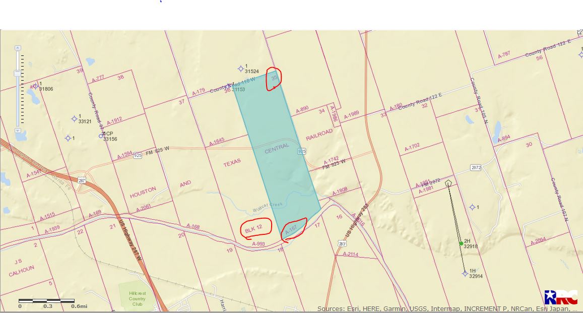
DOUBLE LEFT CLICK ON MAP TO ENLARGE
Are you receiving some interest in leasing in your area?
Clint Liles
Clint,
Thanks so much for the information. We are shocked to even find out that they drilled on or near the property. This is the first we have heard. Seems a lost cause though. Are we pissing up a rope? I don’t see that there is any drilling going on within miles of the property.
Any suggestions??