I’m new to the forum and wish to ask if anyone has any information on Block 78 Section 33. I’ve received numerous offers to sell which I’m not inclined at all to do. However, I received a fairly good offer to lease my mineral rights, as compared to several years ago. I am pretty far removed from this area as I live in Colorado and my knowledge is fairly limited as well.
If anyone has any insight or a drilling map, such as the one like Section 95 provided by Mr. Liles, I would appreciate any info you can send my way.
Welcome to Mineral Rights Forum and Loving County Group. Do you have a Township # like T3S or such or an Abstract #??? Unable to pull up your minerals area with just the Block and Section.
Not sure. What it says is the SE/80 of the NE 3/8 of Section 78, Block 33, H. & TC Ry. Co survey, Loving County, Texas, containing 80 acres more or less. I then have an interest. If that’s not it, I’ll need to look further.
I have to go to the hospital to check on my wife. It will possibly be around 9:30 PM before I can check further but will do so later. Stand by…
Clint Liles
Karen said:
Hi,
Not sure. What it says is the SE/80 of the NE3/8 of Section 78, Block 33, H. & TC Ry. Co survey, Loving County, Texas, containing 80 acres more or less. I then have an interest. If that’s not it, I’ll need to look further.
I’m a real dummy. It’s Block 33 Section 78. The rest of the description from above is correct. I’m so sorry I wrote it incorrectly. I truly appreciate your help.
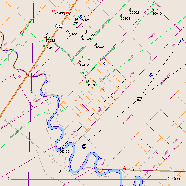
One shows all historical production (oil / green and gas / red) in Block 33 along which runs along the river.
Zoom shows Section 88 (section with “Great” in the middle of it plus four green / oil wells (old shallow production).
Note the adjoining Sections with the long NE to SW running lines. These are horizontal wells - mostly permits, but a couple of Apache Wolfbone horizontals NW of Section 88.
You can see that Section 88 is a “gap” in the horizontal drilling scheme in this area.
Well # 32169 was spudded (began drilling procedure) on June 3, 2014. The targeted formations are Wolfcamp and Bone Springs. No completion report available yet on RR Commission website.
Hi, so should I presume that my mineral rights are not in one of the abstracts? If a company is trying to lease my mineral rights, does that mean they are trying to put together an area ( abstract) to drill? I I don’t know much at all and am trying to get up to speed quickly.
I may be wrong but the way I read that SE 80-N/E 3/8 is the 320 acres that is A-747, your 80 acres would be in the area of the numbers A-747. I could be wrong about that though. It would be better to view it on a County plat map. If I'm wrong someone please correct me and help her.
I may be wrong but the way I read that SE 80-N/E 3/8 is the 320 acres that is A-747, your 80 acres would be in the area of the numbers A-747. I could be wrong about that though. It would be better to view it on a County plat map. If I’m wrong someone please correct me and help her.
Concerning Block 33 Section 78, it is under lease to Matador Oil and about a month or so ago I spoke to someone there (I don’t remember his name) and was told they had already pulled their permit and they would be drilling within 2 weeks. Hope this helps.
Well that is concerning to me as no one has contacted me for a mineral oil lease. I do have a prospect and someone is sending me info. Any suggestions?
Well that is concerning to me as no one has contacted me for a mineral oil lease. I do have a prospect and someone is sending me info. Any suggestions?