Hello, I have several acres of mineral rights in Converse County in the:
Section 23 Township 34 North Range 69 West
location, and the past month or so have gotten contacted out of the blue by several different entities in Texas and Oklahoma wanting to buy the rights… making offers in the realm of $3,500 to $6,000 per acre.
Apparently, something is up. Could you give me an idea of what activity is happening in that area?
1 Like
DSM, this looks like an active site so I think you’ll get some response. In the meantime here are a couple of things that might help you get started.
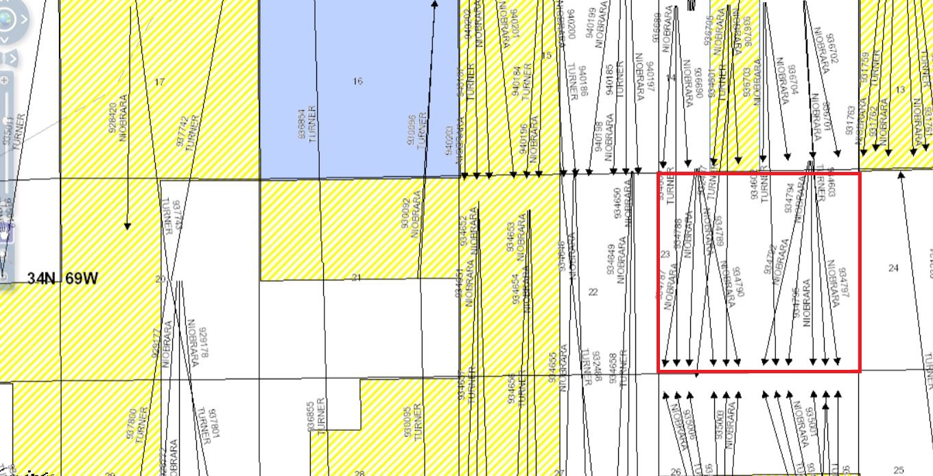
Look for a topic in this section called Wyoming GIS viewer. I’m attaching a link below for the Wyoming Oil & Gas Conservation Commission that was posted under that topic and there is also discussion there on how to use it. After playing around with it a little I’m attaching a map I think covers your area. If the section I outlined in red is yours it looks like there is a bunch of activity… at least a lot of horizontal wells permitted. I wasn’t able to pull up completion information on them which appears to be marked “confidential” in that system but I’m thinking several of them have already been drilled since the permits were approved over a year ago.
The permits were filed by Chesapeake but the current operator appears to be Anadarko. Bottom line is, if that’s your area it looks like a lot is happening there so don’t sign anything until you’ve learned more about it.
http://wogccms.state.wy.us/flexviewers/unitmap/
1 Like
Thanks so much!! I really appreciate the response!
Also had something that was “Lebar 11-34-69” is that in the same area??
You said you have recently gotten purchase offers. Is your mineral interest leased?
I’m focused on Texas. Hope someone will respond who is familiar with Wyoming. If not, you can try responding to one of the previous posts in this Converse County chain.
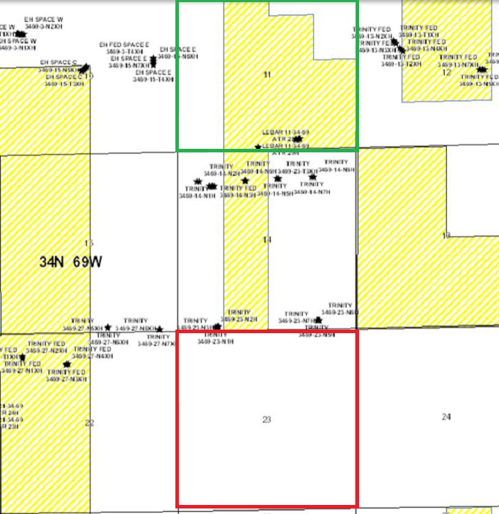
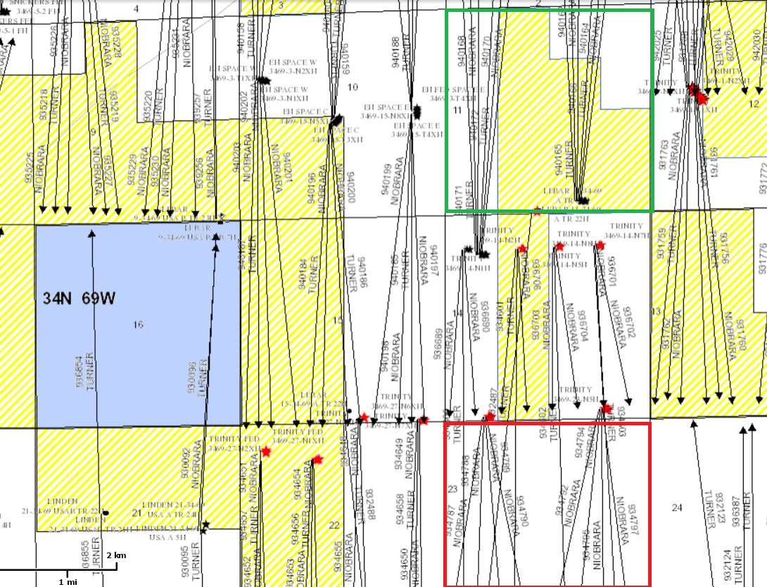
Attached are two more maps from the Conservation Commission’s site. I outlined Section 23 in red and Section 11 in green. Looks like there are also a number of permitted or producing horizontal wells operated by Anadarko that cross Section 11. Also looks like the minerals are federally owned in a lot of that area. Unless you have an undivided interest in those full sections, you need to pin down where yours are located in each of them.
1 Like
Thanks again for replying… I have mineral rights to a few acres. Way back in 2012, I leased them for 5 years to Chesapeake. They sent another check in 2017, but no paperwork for anything.
Then last year, I think in June, there was a hearing scheduled on some supposed drilling permit, but it got withdrawn a day before or so?
…and how to pinpoint exactly where one’s acreage is at?
From your comment about Chesapeake sending another check in 2017 at the end of the term of your lease it sounds like your lease may have included an option giving Chesapeake the right to extend your lease beyond the initial five year term by making an additional bonus payment. No additional paperwork would have been required for them to do that.
Check the wording of your lease. Did it include an option, and did the amount Chesapeake paid you equal the bonus required to exercise their option to extend? Based on the operator shown on the permits that have been filed and wells that appear to have been drilled involving Sections 11 and 23 it looks like at some point Chesapeake assigned their leases to Anadarko.
Regarding how to pinpoint the location of your acreage, you would need to look at the legal description of your mineral interest in the deed, or other legal document, by which you obtained title to that mineral interest. It should describe which part of those two sections your interest is located in, and you could then compare that to the drilling plats showing the acreage covered by those various wells. If you don’t have a deed or other legal document describing where your interest is located some title research in the Converse County deed records may be required to find those documents.
I got notified in 2012 out of the blue that I had mineral rights (because of something my late wife’s grandfather got in the 1950’s!) only docs I recall getting were those to sign to lease out the rights to Chesapeake. I probably have the docs SOMEWHERE, but haven’t seen them in 7 years. I do have the paperwork they sent me last year, when supposedly they were going to court to get some kind of permission or something…I can cut and paste or send location info that is on those documents–they would have that specific location information, right?
I was wondering why they had that hearing scheduled, then decided to cancel hearing at last minute…
And how to find out if Chesapeake sold the lease (or whatever) to Anadarko? Should there have been some sort of notification?