Hello, I’m looking to lease my minerals. Location is Dawson County.
All of the Northwest quarter of Section Four, Block 1, J. Pointevent Survey, Certificate No. 2/230, Abstract No. 766. Please contact me if any work is happening around there or any planning. Thank you ![]()
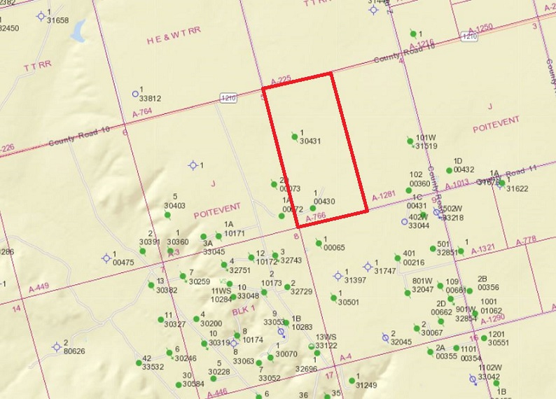
Attaching the current Railroad Commission map of that area with Abstract 766 outlined in red. Don’t see any activity nearby since the 1980’s. The well on the south end of your survey has been producing since the 60’s but hasn’t reported any production since September.
It looks like there is considerable leasing and horizontal drilling going on in Dawson County with CGS/EOG, Reliance, Beach and Pinon some of the most active, but the activity seems to be a good distance south of you below Lamesa.
Wow thank you so much! I appreciate the info. Do you think it could be a potential spot for drilling ever? Again thank you kindly ![]()
Ok I have another question if there has been production up until September. Why has no one contacted me on these mineral rights? What should I do? I really do appreciate anyone’s knowledgeable help. Trust me it’s helped ![]()
Hi Melinagail, from your description of property being in the NW quarter of the Abstract/Section, and the semi-active well being in the SW corner, it is possible that this well was not ever involved with your mineral holdings. With older, vertical wells the leased area was often much smaller than the whole Sections or multiple Sections used by newer horizontal wells. Also noticed on your map that there are permitted locations in the Sections adjacent to yours, so the future may not be entirely bleak. I don’t, however, have a crystal ball, and my opinions have no professional weight. Just trying to give you some peace that nothing in your situation looks abnormal to a fellow mineral holder.
Melinagail, I agree with what PeteR told you.
If your mineral interest is the northwest quarter of Section 4 Block 1, it is outside the boundaries of the unit for the well on the RRC map that I posted. That well called the Gfeller is operated by Sahara Operating and according to RRC has been producing since the 1960s, but it is in the southwest quarter of Section 4, Block 1. There aren’t any records online that go back far enough to include a plat, but the producing unit for a vertical well like that normally wouldn’t cover more than 40 acres.
RRC’s map does show a vertical well was drilled in your NW quarter of the section, but it was plugged and abandoned in 1979.
Thank y’all for the advice and knowledge. The capped-off well, do you know if it was Gulf Sanders? It was my great-grandfather’s well. It did produce many moons ago. If so, would there be potential that part of the area might still produce oil? Thanks again.
Yes, RRC records show that plugged well in your part of Abstract 766 was called the Gulf Oil - A. Sanders, and the field name was the Felken (Spraybeberry).
The link below should take you to the plugging report that shows it was completed 4/9/75 and plugged 4/28/79. The potential test made after the well was completed in 1975 shows it made 13 barrels a day of crude with a very small amount of natural gas.
Don’t have any guess about the potential for future drilling in that area.
Does anyone who lives in the area know of actual production on the EOG leases in Dawson County?
I am not from the area, but viewing the information on the RRC indicates that there are 39 producing leases operated by EOG Resources in Dawson County. Not sure which area of the County or lease you are interested in.
I have another question and thank you all so much. This is great knowledge I’m learning a lot. Back in the '70s did they drill as deep as they do now? That’s why I’m wondering if there would be potential oil still in that region… Again thank you for all your help and God bless.
It is an involved process, but one can also look up production on the Texas Comptroller’s Crude Oil and Natural Gas Lease Drop - Crude Oil Inquiry page which has not yet posted to the RRC’s Production Data Query system. CONG shows CGS Operating’s Santorini drilling permit number 862276 to have produced a little more than 100,000 barrels of oil May through September 2020. Search mineralrightsforum for CONG; CGS Operating, etc.
It is an involved process, but one can also look up production on the Texas Comptroller’s Crude Oil and Natural Gas Lease Drop - Crude Oil Inquiry page which has not yet posted to the RRC’s Production Data Query system. CONG shows CGS Operating’s Santorini drilling permit number 862276 to have produced a little more than 100,000 barrels of oil May through September 2020. Search mineralrightsforum for CONG; CGS Operating, etc.
Thank you, I appreciate the info. It’s all new to me and very interesting. I’m still trying to understand how it works. I’m guessing a drilling company would contact me if they thought there was oil on that certain area? I’m going to research the info you sent me. I appreciate the insight.
This topic was automatically closed after 90 days. New replies are no longer allowed.