Looking for contact information for NRM Operating Company and affiliate companies formerly drilled in Logan County.
What section, township and range? They may have sold and the new operator can be found on the form 1073.
There is NRM Petroleum, Corp in Texas. Any affiliation?
1 Like
S ½ S ½ NW ¼ of Section 9, Township 15 N, Range 1 W, I.M.
1 Like
Possible affiliated companies are NRM Operating Company LP NRM 81 B Income Royalty LTD NRM 82 A Income Royalty LTD Natural Resource Management Corporation
Thank you. Where can I check OCC filings for any operator changes tied to the mineral tract?
TY, Yes they plugged it in 1986 under well name She-She 1. However OCC shows it under Donna #1. I do not know how to contact the legacy archive for OCC. It seems to be multiple owners with different PUNs and APIs. Looking for unidentified heir royalties from est. 1980-1986 with producer or/and State for intestate probate.
The She-She 1 well was API 3508321862 which was drilled by John T. Reitz and CO Inc. then sold to Natural Resource Management Corp. It had only 45 months of production and was plugged and abandoned. |Surface Lat:|35.796787|Section:|09|Last Completion Date:|10-16-1981| Note the different well locations on the permits. It was drilled in the NE4, so not on the acreage you listed, but the NW4 was included in the spacing order. Last production was July 1985.
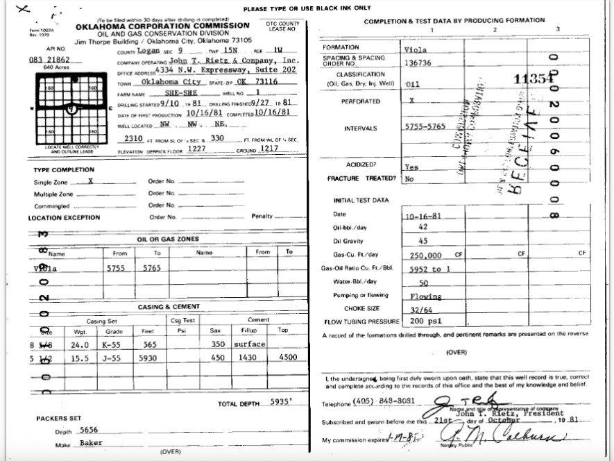
|Surface Lon:|-97.3085878|Township:|15N|01W-sec 9
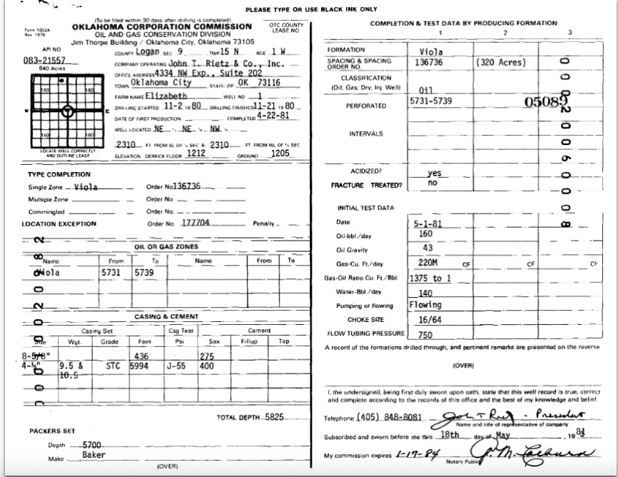
The Donna 1 is a completely different well drilled in a completely different location by Rietz John T & Co. Inc. API 3508321555. I do not see any production listed for it.
| Surface Lat: | 35.7931706 | Section: | 09 | Last Completion Date: | 10-03-1981 |
|---|---|---|---|---|---|
| Surface Lon: | -97.3131274 | Township: | 15N | 01W-sec 9 | |
|  |
Elizabeth was also drilled in the NW 4. It had 10 months of production.
Most likely that any funds that were in suspense were escheated to the state within four years of not finding someone. These were not very good wells.
1 Like
Thanks so much for updating me! It was very helpful and appreciated. Address is often listed as:
S9 T15N R1W S2 NW Partial -OR- S ½ S ½ NW ¼ of Section 9, Township 15 North, Range 1 West
This is the info OCC emailed me a few months ago. However, they stated they do not keep details online prior to 1990.
OCC email: Oil stored in a tank and plugged in 1990 (maybe a battery) Donna #1 Active: 8/3/1981 Ceased 11/01/1984 3.3 years API: API 35-051-22654 PUN: 083-070390-0-0000
Here is the listing for Donna on the tax records. Pretty sparse. https://oktap.tax.ok.gov/oktap/web/_/#5
1 Like
I see Elizabeth API under an additional producer: CAREY GULF and is operated by Gulf Exploration LLC.
Thank you for the research. I have learned a lot since we chatted. I am preparing letters of inquiry now. However, OCC states that the information is maintained by Logan County, and that research reflects it falls under OCC.
This topic was automatically closed after 90 days. New replies are no longer allowed.