Let’s say I have 6 tracts totaling 500 acres in an abstract that has roughly 2,500 acres (Leon County, Texas). How can I find out specifically where my tracts sit within the abstract? The division order provides a map but I don’t know where our abstracts are within the map that they provide. I will soon join NARO; maybe they can help? Thank you!
3 Likes
Do you have acreage spread out between multiple abstracts? Or are you saying there is one abstract number which has 2,500 acres and you have interests in certain sub-tracts? Within a county, each abstract number is unique as to the acreage as the abstract number was issued by the General Land Office when the tract (could be all or part of a Section or Survey) was awarded by Texas to an owner.
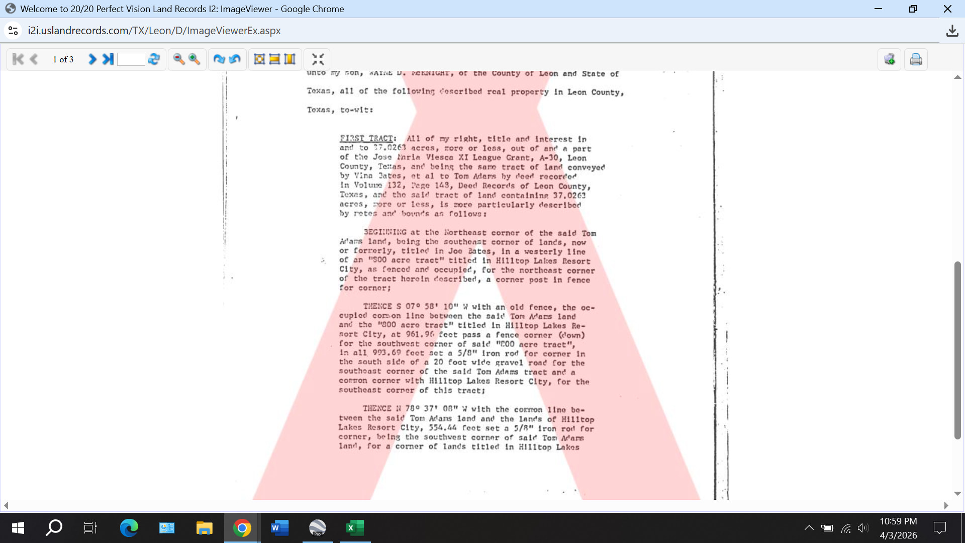
On RRC GIS Viewer, you can search by county and abstract number to pull up the location of the abstract within the county. Read the legal description in your deed or lease for each abstract number/Section/block to determine where your minerals are located within the abstract. If you post one sample legal description, someone can give you more guidance to locating where your minerals are. On a side note, the division order describes the acreage allocated to the unit or well, and you may or may not own minerals within the entire area.
3 Likes
I believe they are asking for the same information that I am seeking. We know the abstract number and the royalties interest simply states “X acres within Abstract XYZ.” So how does one know where within the royalty rights are located? In some cases ours are listed as being within adjoining abstracts.
If you’ve signed a lease, your lease should have the legal description on it. You can then use the RRC GIS viewer to find your abstracts.
1 Like
You may be mixing two things. First, you need to map your minerals based on the legal description(s) in the lease. There will be a separate legal description for each tract. The tracts may all be in different abstracts or possibly two different tracts within one abstract. You can locate the abstracts on the RRC GIS Viewer. The division order will reference the minerals located within the unit or within the area allocated to the well. You can see this on the permit plat or the as-drilled plat. The well acreage could include all or only a portion of your minerals. You will have to overlap the minerals map and the well map to see which minerals are included in the well. Both of these maps will be the gross mineral acreage. Your net minerals will depend on your fractional ownership in each mineral tract.
1 Like
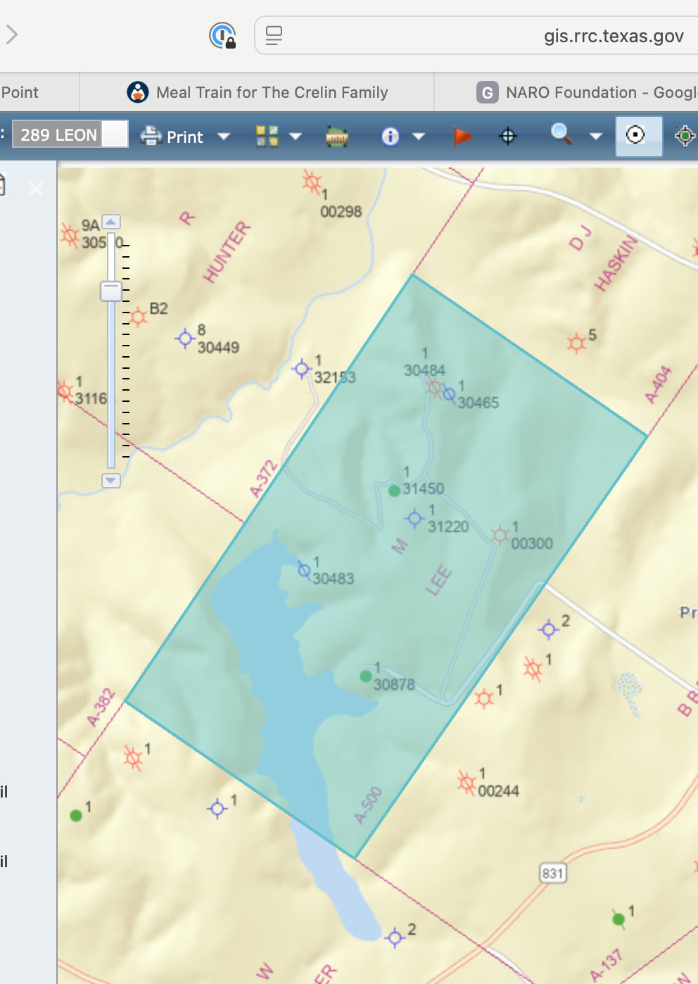
For clarification, I think gergs1973 is asking the following: How does one find out where a block is located within an abstract? For example, a particular tract in which I own mineral rights is described as “81.98 acres of land, more or less, being Block 4 of the M. C. Lee Survey, A-500, Leon County, Texas.” It’s easy to find A-500 on a map. But how does one find out where in A-500 is Block 4?
1 Like
This is common in many Texas counties, particularly in the western part of the state. Tracts were carved out and sold for farming and settling, sometimes to access a canal or other water source, even in square 640-acre sections.
Hi Nielloeb, I own minerals in that same tract in that same survey. Are you getting any leasing inquiries on it, can you say? Thanks.
1 Like
Gergs - I once asked my oil and gas attorney the exact same thing I believe you’re asking. She is a former landman and now specializes in title work.
Her exact response: “I can attempt some rough mapping of the interests, if I can deed plot the legal descriptions (I don’t have a good deed plotting program, which is what you use to convert the metes and bounds description in a deed to an actual picture of the property lines).”
So it sounds like you need to “plot” the metes and bounds in the legal description of the deed. Not an easy task, but possibly made easier if you have an app that does it for you.
1 Like
The example block I gave is leased by us to Mitsui. The abstract contains 320 acres. I think my ownership is just that 81.98 acre block. Comstock just contacted me about leasing about 10 miles SW of that.
Very interesting. I’ll have to check my files. These were minerals owned by my great-grandfather, and I thought the tract was part of an 81-acre tract. I know for sure it is A-500. It’s the Shelly Pate lease historically. I’ve not heard from Mitsui, but we have heard from Surprise Valley/Comstock. Thanks.
Okay, we are in Block 2, but same size tract, 81.98 acres, but different block. I wonder how far apart they are by distance.
This might be it. First picture is from the RRC. Note the shape of the lake in the larger abstract.
1 Like
That looks right, but the four 81 acre tracts which make up A-500 have been further divided. I have an old lease from the 1990s which is 50 acres–a portion each of two different 81 acre tracts. This Abstract appears to have been sliced and diced many times since my great grandfather owned it. Thanks!
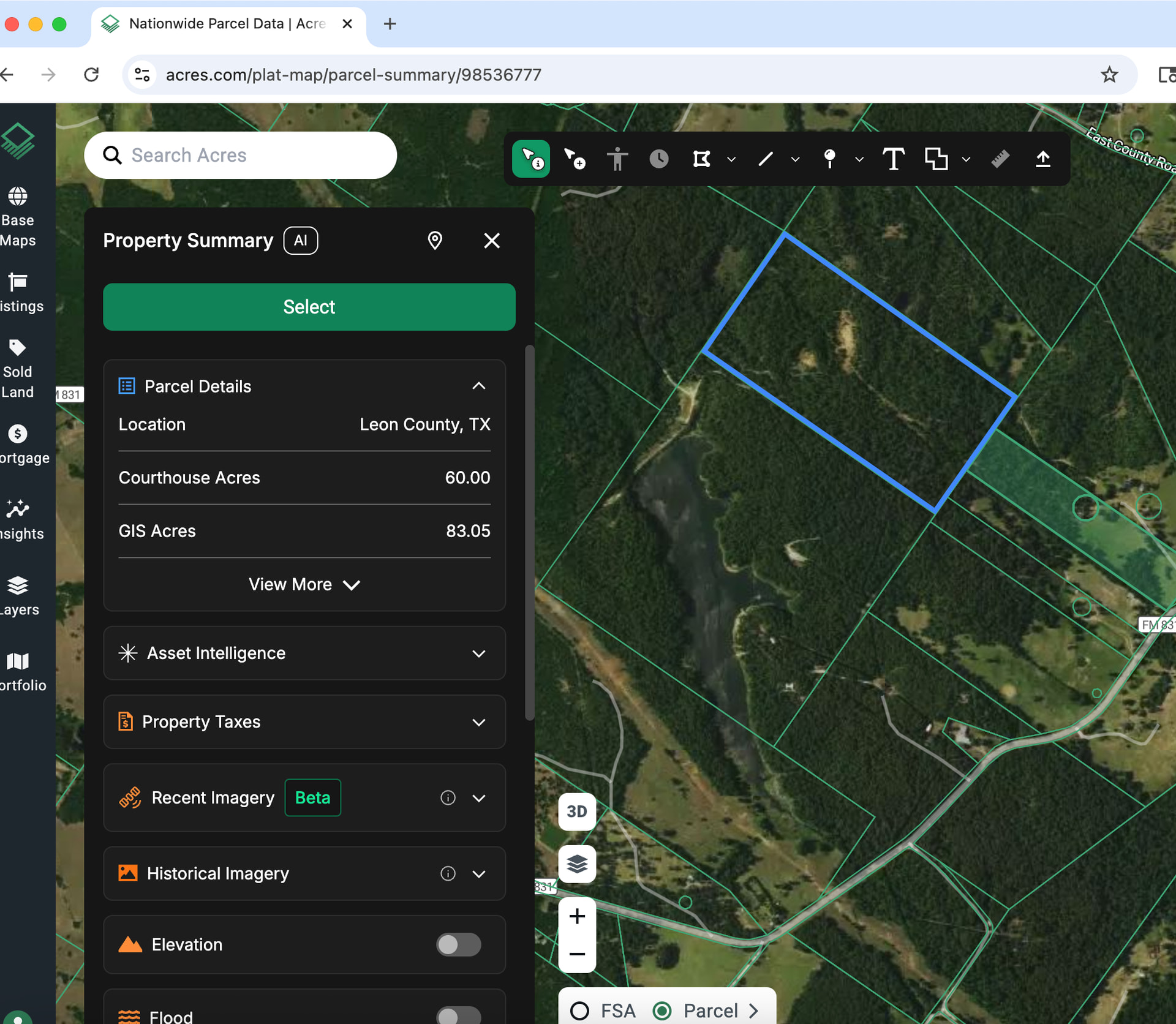
As you can see on the green parcel map the portions to the upper right of the one I marked in blue have been further divided. You would have to use the metes and bounds descriptions to get a better answer.
I too am interested in finding where our minerals are located within the various Abstracts, as the deeds specify tracts that were patented or parceled out back in the late 1800’s and early 1900’s. I’ve looked at both the TRRC and CAD maps and, apparently, many divisions have taken place since our deeds were conveyed in 1947. I tried plotting several of them, using CAD maps, but in the couple cases I tried, the POB references no longer exist.
I thought about hiring a surveyor, but that would be way too expensive.
Any suggestions as to how to locate the tracts without spending a fortune?
Thanks, JN
1 Like
@Jneves2629, sometimes there are plat maps or sketches available in the county records. A metes and bounds description may be accompanied by a sketch. These maps and sketches can help you step back in time and find reference points that are referred to in your original deeds. Sometimes the traces are still visible in the modern parcel maps, and sometimes it has been completely redone and you need an older map for reference.
Thanks PeteR. My father was a surveyor and I worked for him during summers. He would send me to the county clerk’s office to look up information on those old map and deed records. Can you still go to the clerk’s office and access those old map books?
Thanks, JN
@Jneves2629, the policies to access documents probably vary by county. Some even allow on-line access. No guarantee it will work, and you have to work back through your title chain and perhaps those of neighboring properties until you can find a good reference. That being said, I’ve been able to find maps or descriptions with durable reference points back into the 1800’s that really clear up where the property in question is actually located. The monetary price is usually low, but it does take some time.