I own the mineral rights on 52 acres in Reeves County, Texas Section 136, Block 13, H&GN RR Co Survey and was wondering what leases were going for in the area. Our current lease with CW has expired and I don’t think they are offering me the money the lease is really worth.
James, I recently was offered $1,200 per acre, which I believe is low for central Reeves County, Texas. My property is in Block C-18, Section 4. Many other quotes I have seen in this blog were running up to $3,000 per acre.
r / fred
James, I was offered $1,000 initially, but asked an oil-gas attorney by the name of Wade Caldwell to negotiate the lease bonus and make sure the legal language covered my interests. He did a great job. Got me $3,000 per acre bonus. You may want to consider giving him a call. He is part of this blog site.
JAMES,
LINK TO A COMPLETION REPORT OF A WELL EAST OF YOUR SECTION 136:
GIS MAP OF YOUR SECTION 136 AND SURROUNDING AREA:
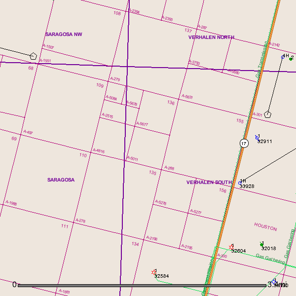
Clint,
Do I need to have a user ID and password to view completion reports on the RRC?
JAMES,
Use this link to put in the API # and click on submit. Then click on links and then click on completion.
CLINT LILES
1 Like
Clint,
I’m sorry I am so dumb but where do I get the API number?
Every well is assigned an American Petroleum Institute number.
In Reeves County:
42 (TEXAS) 389 (REEVES CO) 12345 (well number)
Usually you omit the 42 and just type in the 389 and the particular number.
Now just click on the link Clint Liles gave you, the PDF version of the completion report will come up, there you will see the API number in the Upper Right Corner.
On the GIS map old version, you can enter the API number to find the well’s location on the map.
On the new GIS interactive map, the identify feature will display the well’s API number.
1 Like