Our family has been given an offer to lease our mineral rights. The offer is $75.00 an acre. We have 132 acres between Lindale and Winona area. It is due North of Tyler.
This is for a three year lease with option to extend for two years. Is this a fair price? I see lease prices all over the board.
Richard:
I was contacted in November by a company wanting to lease my mineral acreage just East of Lindale (Maria De Los A. Carmona Survey) for $200/acre; 3 years; 3/16th royalty. This acreage is just North of Jim Hogg Road approximately 3 miles East of Lindale. No extension provisions in the lease. Now the area you describe is most likely farther to the East of mine possibly closer to the Red Springs area so you can’t draw any conclusions to what I was offered since the areas appear to be miles apart but find out the locations of nearest activity and negotiate from there. I’m thinking that the bonus is on the low side but the main issue is the % royalty. Further, I would not agree to any extension as this will only prolong any anticipated drilling activity and short change you in the long run. Hope this helps.
Our property is west of Red Springs about two miles up Old Dallas Shreveport Road. There is a creek that runs directly through the center of the property. They refer to it as the Jolly Partial. So yes, we are east of you and a little north.
Thank you for your response, we do appreciate it.
Richard,
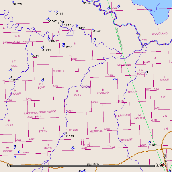
What is your Abstract #? Let’s check the GIS map and as Charles says let’s see what kind of production is around your area.
Richard:
From the description you have given, I believe that a new well has been permitted to the north of your area near the Sabine River Management area. I believe that the well was permitted for the Crow Field. There are several wells in the Sabine River Management area which used to be operated by John Linder. I inspected these areas when I was employed with the RRC of Texas. If I recall, someone drilled a dry hole near the Sabine River Management area years ago, probably late 90’s.
I don’t see anything on the lease that says abstract # but this might be it.
TX011-423-507-03 Also on the lease is A-507 A911
Sorry but I know very little about how land is identified in Texas.
Richard,
The A-507 is the abstract #. After pulling this up on the RR Commission GIS Map I see several dry holes in the surrounding area and 2 other permitted holes (1 dating to April 1990 and another dating back to August 2000). Am not sure either of these permitted locations were ever drilled.
API # 323-31259 was for an 8,300’ vertical well by Rosewood Resources in A-920 5.1 mi. NE of Lindale. (April 1990)
API # 423-31535 was for a 17,000 vertical well south of A-507 in A-905 (August, 2000)
I see no production in your immediate area.
Am including a GIS map of A-507 and surrounding area:
Clint Liles
Richard,
Here is a link to Mineral Rights Forum Smith County Group. We welcome you to join us.
http://www.mineralrightsforum.com/groups/4401368:Group:231575
Clint Liles
Yes that is a fair price for that area.