Hi, I was hoping someone could tell me, if anything is going on with my property. I have 20 acres ( E 1/2 of the NE 1/4 OF the NE1/4 Section 14 Block 7, H&Gn ry.co. survey. Thank you William Sweeney
William I don’t see any activity in Section 14.
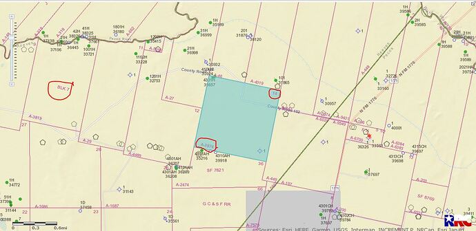
GIS map of Reeves County Section 14/Block 7/Abstract 3874
DOUBLE LEFT CLICK ON MAP TO ENLARGE
Thank you Clint… I only own the surface rights, do you think there isn’t anything worth drilling for under there. I don’t know who owns the mineral rights, nobody has ever contacted me about anything…thank you again. Billy Sweeney ps. Is that abstract # for my property. Also is that heighten square my 20 acres?? Was only there too see it once, and I couldn’t tell where it started and ended. ![]()
Bill that area in blue is a full section 640± acres. Your 20 acres is located in the top right corner of this Section 14…and there are some very good oil/gas wells in this area. The Abstract # is for that whole Section.
Clive,thank you for the information. I was wondering if I might ask you a few more questions?? Thank you Billy Sweeney
Sure Bill, I’ll try to answer more questions…If I can’t hopefully others will chime in.
This topic was automatically closed after 60 days. New replies are no longer allowed.
