Looking for information for my grandparents on property which has an oil well on it. Where should I start? Numbers are SE1/4 NE1/4 Section 8 Township 12 N Range 2 W in Jefferson Ridge. Appreciate any help, thanks.
You need to add the state and county.
I apologize it is located in Oklahoma County off Sooner Road area called Jefferson Ridge. Thank you Ms. Barnes
The wells in the NE quarter have been plugged and abandoned. Looks like all the wells in that section are done. Were they part of a waterflood unit that might extend into another section?
Ms. Barnes, thank you for the information. I spoke with my mother-in-law. My understanding is that there is a pipe that runs underground across the road to another well. Is it possible? Also, if the well is capped off, can oil be diverted and pumped from her side of the property? There is also gas but it is capped. I haven’t been back since 1982. Where can I start to trace the list of royalties on the abstract which dates back to the early 1930s? She hasn’t been updated since 1975. She’s 90 years old and I’m just doing what I can to help. Hopefully your advice can help me obtain whom to contact. Thank you again.
Here are some useful free sites that may help you. The WellRecords one will be most helpful. Put 0812N02W in the Legal Location box. Then hit Search. You can sort by Legal Location or Well Name, etc. Since she has property in the NE quarter, the look for the wells that have NE as the last term in the legal location. The information for each well is there. Form 1002A is the completion report for each well. Form 1003 is a plugging report. I cannot find any modern information on any actual production from those wells. They may have had minimal production and then were abandoned and plugged back in the 1950’s. Vivette had an initial test of 150 bbls oil per day, but apparently did not last more than a few years. Slaughter had 17 bbls per day, but I do not think her acreage would have been in the spacing of the well. It is in the NW4 of the NE4.
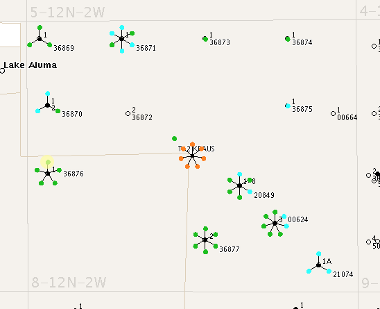
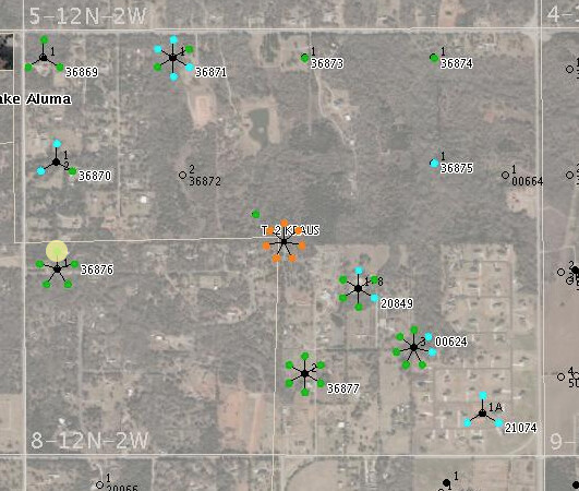
Here is a map from another source-one with just the wells and once with the satellite data. The wells that might concern her would be 36873 (Slaughter 1-drilled 1950-plugged and abandoned 1956), 36875 (Mitchum 1-dry hole no production), 36874 (Vivette 1-drilled in 1950-plugged and abandoned in 1956) and 00664 (?-really old-no information).
The Oklahoma Corporation Commission has very strict rules about spacing and what wells can drain. These were fairly shallow wells that can only drain a small area and they did that pretty quickly back in the 50’s and then they were done. If they are plugged, they cannot drain any more.
Pending OCC cases at the following link: http://www.occeweb.com/caseprocessingonline/default.aspx Actual cases if you have the case numbers: OAP Docket proceedings: http://www.occeweb.com/ap/docket_results.html Well activity: Test Production: https://otcportal.tax.ok.gov/gpx/gp_displayPublicPUNListSearchDownload.php
If you are searching for deeds, probate orders back to 1983 try this: https://okcountyrecords.com/search/jefferson#advanced-search
SE 1/4 NE 1/4 Section 8, Township 12 N, Range 2 W Jefferson Ridge. Looking to find out how long did the British American Oil Co. production of oil last. Looking to research where or who royalties were paid to. How are the royalties divided and how much would they receive? Abstract goes back to 1932. Is there an easier way to search? Any help would be appreciated.
The Slaughter well only produced 7704 bbls of oil from 1950 to 1956. Harper Turner Oil Company
The Vivette well only produced 29,929 bbls of oil from 1950 to 1956. Harper Turner Oil Company
These are very low production amounts. They would have been paid to the royalty owners at the time of production. The split would have been in proportion to how many acres were owned within the spacing units. OIl prices were very low back then. Only place to check if any money was not paid out would be to check the unclaimed funds for the OK Treasurer’s office.
Where did you find British American Oil Co? I do not see them listed.
There is a pipeline nearby according to the NPMS website: https://pvnpms.phmsa.dot.gov/
The pipeline does appear to be across the street from the NE corner of Section 8. (See attached picture).
Not sure of the date on the pipeline, but probably not relevant to wells that were plugged back in the 1950’s. At that time, there would have been a tank on site and trucks would have picked up the oil (most likely).
The equation for royalties is net acres/actual spacing acres x royalty x % perforations in your section.
For example, if one had 10 acres at 1/8th royalty in an 80 acre spacing, the the decimal amount would be:
10/80*.125*1.0=.015625. For every dollar of product sold, the royalty owner would get that decimal amount. So about 15 cents for every $10 sold. Probably very unlikely to recover any royalties this many decades later unless they are sitting at the state Treasurer’s office. If operators cannot find the mineral owner, they will put the money aside for several years and then escheate (transfer) the money to the state treasurer.
I notice on the abstract it had British American Oil Co. not sure if they were the Co. back in the late or mid 40s. I do remember seeing Turner Oil Co. on record also. Mr. Peter R does see pipe on NE corner running across the road. Does there show any activity? I recalled there is a pump across the road running from the well on the property. Are the wells within that Section still producing?
The operator of record for the wells when they were producing is who is responsible for paying royalties. Once the wells were plugged from the 1950’s lease, the lease is over unless there were increased spacings and drilling during that time frame that would have extended the lease.
The spacing orders that I found were generally 40 acres which was common for an oil well at those depths for that area. So no 640 spacing that might have included other wells in the section. There is a unitization order but it does not include the NE corner of section 8.
The Vivette well produced from the Misener Sand which is below the Cleveland Sand and above the Hunton Lime. The well is in the NE4 NE4.
The Slaughter well produced from the Cleveland sand but was not in the spacing of your grandparents’ acreage since it is in the NW4 NE4.
The only well drilled on your grandparents’ acreage was the Mitchum well in the SE4 NE4 and it was dry. So it looks like they may not have had any royalties at all if the spacings are all at 40 acres which is what the map looks like. Given the depth and porosity of the reservoirs, each productive well would have only drained a very small area just around the wellbore.
Not quite understanding your question about the section with the pipeline which is in sec 9 among others to the north and south. Any production in those sections does not relate to production in the NE corner of 8. I suspect that pipeline is much newer than the 1950’s.
This topic was automatically closed after 90 days. New replies are no longer allowed.