My grandmother had an oil, gas, and mineral lease from 1983 with Samedan Oil, which was acquired by Noble Energy, which was acquired by Chevron. The land is in Wood County, Texas. I am unaware if my grandmother ever received royalties and my mother (who has recently passed) never investigated the lease. How do I get started to determine if the lease is valid and if oil, gas, or minerals were found on this property? I have a notarized copy of the signed lease. I am unfamiliar with this topic. Thank you.
You can either look up the description of the acreage by block, abstract and section on the Texas Railroad commission GIS site, or you can post them here and someone on the forum can look it up to see if there are any wells.
Can someone tell me if (a) drilling was done and if (b) any oil, gas or minerals were found on the following THREE properties in Wood County, Texas between 1983 to current day? I am not familiar with how to use the Texas Railroad Commission GIS site, so would greatly appreciate someone from this Forum to look this up for me. All 3 properties are in Wood County, Texas. Thank you in advance.
Property #1: (Approx 7 acres) BEGINNING at a 1/2 inch iron rod found at a fence corner at the occupied Northeast corner of said 38.33 acre tract; THENCE SOUTH 00 deg. 31 min. 49 sec. East along the East boundary fence of said 38.33 acre tract, a distance of 703.20 feet to a 1/2 inch iron rod set for a corner; THENCE NORTH 89 deg. 34 min. 36 sec. West across said 38.33 acre tract, a distance of 696.18 feet to a 1/2 inch iron rod set for a corner in the East right-of-way line of Texas Farm Road No. 1799; THENCE NORTH 02 deg. 03 min. 05 sec. East along said right-of-way line, same being parallel with and 50.00 feet from the centerline of said Farm Road, a distance of 589.57 feet to a 1/2 inch iron rod set for a corner in the occupied North line of said 1.00 acre tract; THENCE NORTH 89 deg. 37 min. 59 sec. East along the occupied North line of said 1.00 acre tract and a North line of said 38.33 acre tract, a distance of 380.35 feet to a 1/2 inch iron rod set at a fence corner at an occupied ell corner of said 38.33 acre tract; THENCE NORTH 01 deg. 26 min. 16 sec. East along a West boundary fence of said 38.33 acre tract, a distance of 104.67 feet to a 1/2 inch iron rod set at a fence corner at the occupied most Northerly Northwest corner of said 38.33 acre tract; THENCE NORTH 89 deg. 38 min. 53 sec. East along the most Northerly North Boundary fence of said 38.33 acre tract, a distance of 285.58 feet to the POINT OF BEGINNING and containing 10.000 acres of land, more or less. And being the same land as surveyed by Turner & Associates during the month of October, 1931, field notes prepared by Homer C. Turner, Jr. Registered Public Surveyor No. 2291, for the State of Texas, dated October 9, 1981.
Property #2: BEING a 7.149 acre tract of land situated in the HELENA NELSON SURVEY, ABSTRACT NO. 431, Wood County, Texas and being a part of a called 38.33 acre tract described as “SECOND TRACT” in a Deed from Mollie Benthul to Mattie Fay Bullard dated April 2, 1974, as shown of record in Volume 685, Page 585, Deed Records, Wood County, Texas, said 7.149 acre tract being more particularly described by metes and bounds as follows: VOL 834 PAGE 507 BEGINNING at a 1/2 inch iron rod set for a corner at a fence corner at the occupied Northeast corner of a called 7.14 acre tract described in a Deed from Nellie Mae Hagler, et al, to Billy Eugene Hagler dated February 5, 1974, as shown of record in Volume 678, Page 670, Deed Records, Wood County, Texas, said POINT OF BEGINNING being in the East boundary fence of said 38.33 acre tract and being South 00 deg. 31 min. 49 sec. East, a distance of 1243.78 feet and South 00 deg. 46 min. 14 sec. East a distance of 446.35 feet from 38.33 acre 1/2 inch iron rod found at the occupied Northeast corner of THENCE NORTH 89 deg. 34 min. 36 sec. West along the North boundary fence of said 7.14 acre tract, a distance of 589.60 feet to a 1/2 inch iron rod set for a corner in the East right-of-way line of Texas Farm Road No. 1799: THENCE NORTHERLY along said right-of-way line, same being along a curve to the right that is concentric with and 50.00 feet from the centerline of said Farm Road, said curve having a central angle of 15 deg. 48 min. 13 sec., a radius of 1859.85 feet, a long chord length of 511.37 feet, a long chord that bears North 13 deg. 26 min. 20 sec. West, a length of 512.99 feet to a 1/2 inch iron rod set for a corner in the occupied South line of a called 1.00 acre tract described in a Deed from N. E. Massie and wife, Lillie B. Massie, to Marion R. Parks and wife, Birtie Parks, dated January 22, 1964, as shown of record in Volume 520, Page 147, Deed Records Wood County, Texas; THENCE SOUTH 87 deg. 48 min. 48 sec. East along the South boundary fence of said 1.00 acre tract, a distance of 170.25 feet to a 1/2 inch iron rod set at a fence corner at the occupied Southeast corner of said 1.00 acre tract; THENCE SOUTH 84 deg. 44 min. 57 sec. East across said 38.33 acre tract, a distance of 534.54 feet to a 1/2 inch iron rod found at the Northwest corner of a called 38.924 acre tract described in a Contract of Sale and Purchase from the Veterans Land Board of Texas to Jerry D. Hackler dated February 15, 1979, as shown of record in Volume 774, Page 713, Deed Records, Wood County, Texas; THENCE SOUTH 00 deg. 46 min. 14 sec. East along the East boundary fence of said 38.33 acre tract, a distance of 446.35 feet to the POINT OF BEGINNING and containing 7.149 acres of land, more or less. And being the same land as surveyed by Turner & Associates during the month of October, 1981, field notes prepared by Homer C. Turner, Jr., Registered Public Surveyor No. 2291, State of Texas, dated October 9, 1981.
Property #3 (10 acres more or less) BEGINNING at a 1/2 inch iron rod set for a corner in the East boundary fence of said 38.33 acre tract and being South 00 deg. 31 min. 49 sec. East a distance of 703.20 feet from a 1/2 inch iron rod found at the occupied Northeast corner of said 38.33 acre tract; THENCE SOUTH 00 deg. 31 min. 49 sec. East along the East boundary fence of said 38.33 acre tract, a distance of 540.58 feet to a 1/2 inch iron rod found at the Northwest corner of a called 38.924 acre tract described in a Contract of Sale and Purchase from the Veterans Land Board of Texas to Jerry D. Hackler dated February 15, 1979, as shown of record in Volume 774, Page 713, Deed Records, Wood County, Texas; THENCE NORTH 84 deg. 44 min. 57 sec. West across said 38.33 acre tract, a distance of 534.54 feet to a 1/2 inch iron rod set at a fence corner at the occupied Southeast corner of a called 1.00 acre tract described in a Deed from N. E. Massie and wife, Lillie B. Massie, to Marion R. Parks and wife, Birtie Parks, dated January 22, 1964, as shown of record in Volume 520, Page 147, Deed Records, Wood County, Texas; THENCE NORTH 00 deg. 45 min. 56 sec. East along the East boundary fence of said 1.00 acre tract, a distance of 222.83 feet to a 1/2 inch iron rod set at a fence corner at the occupied Northeast corner of said tract; THENCE NORTH 89 deg. 04 min. 29 sec. West along the North boundary fence of said 1.00 acre tract, a distance of 179.67 feet to a 1/2 inch iron rod set for a corner in the East right-of-way line of Texas Farm Road No. 1799; THENCE NORTHERLY along said right-of-way line, same being along a curve to the right that is concentric with and 50.00 feet from the centerline of said Farm Road, said curve having a central angle of 00 deg. 49 min. 36 sec., a radius of 1859.85 feet, a long chord length of 26.83 feet, a long chord that bears North 02 deg. 00 min. West, a length of 26.83 feet to a point of tangency; THENCE NORTH 02 deg. 03 min. 05 sec. East along said right-of-way line, same being parallel with and 50.00 feet from the centerline of said Farm Road, a distance of 244.41 feet to a 1/2 inch iron rod set for a corner; THENCE SOUTH 89 deg. 34 min. 36 sec. East across said 38.33 acre tract, distance of 696.18 feet to the POINT OF BEGINNING and containing 7.375 acres of land, more or less. And being the same land as surveyed by Turner & Associates during the month of October, 1981, field notes prepared by Homer C. Turner, Jr., Registered Public Surveyor No. 2291, State of Texas, dated October 9, 1981.
So you know the abstracts for properties #1 and #2?
I appreciate your guidance (I am honestly lost on how to proceed on this topic). What are considered “abstracts”? I uploaded all of the information that I have. Question: based on the description of the 3 properties (listed in my dialogue), do I need additional land location identifiers? Would you be open to a phone call from me? I am a nurse (medical background), and have no background knowledge on oil, gas and minerals. Thank you.
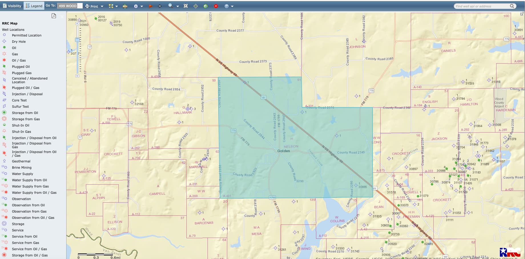
An abstract is a subsection of a county plat. Let me see if I can figure out the middle one and show you on the TX Railroad commission map. When I zoom in, I may be able to find the county roads on the other two if they are close by. Texas descriptions are in “metes and bounds” hence the complicated measurements.
Hello again. Were you able to find the properties on the Tx Railroad Commission Map? If so, has any drilling occurred on any of these 3 properties? I appreciate your time and talents. Thank you again.
Property No. 2, A-431 shows 4 dry holes in all the Helena Nelson Survey. Tim
Here is the #2. The other two are somewhere along FM 1799 which runs NS through the abstract. I see four dry holes in the abstract. You can see them on the TRRC map.
This topic was automatically closed after 90 days. New replies are no longer allowed.