I own 20 acres in Barstow, Texas. I’ve owned it since 2007. I recently found out there are wells and several large storage tanks on the property now. No idea how long they have been there. I live out of state.
I was never contacted by anyone about using my land for drilling & storage. I have no idea who the company is or who the mineral owner is.
Do companies usually contact the surface owner when they are going to install large equipment like this?
How do I find out the company’s name who’s using my land? I’m new at this.
I know surface owners have little say, but they are using the whole 20 acres since the road they are accessing is on the other side of the storage tanks and wells.
What can I do, if anything? Advice appreciated.
I’m assuming you inherited the property, since I doubt you would have purchased a piece of land without inspecting it.
Perhaps the equipment was installed prior to 2007, under an agreement with the previous owner? Sometimes surface use agreements call for annual payments, but some are simply one-time payments which you would have missed out on.
I believe it is law that the company information must be displayed somewhere on the premises. I would start there.
I’m in Minnesota so looking at the equipment isn’t an option right now.
I didn’t see the land when I bought it, it’s just flat desert land. Saw maps etc. The previous owner didn’t mention any activity on the land at that time.
Larry,
Let’s start by giving the Section, Block or Abstract numbers and what County in Texas? ALL the information you have about the minerals in question and post it on here.
Thanks,
Clint Liles
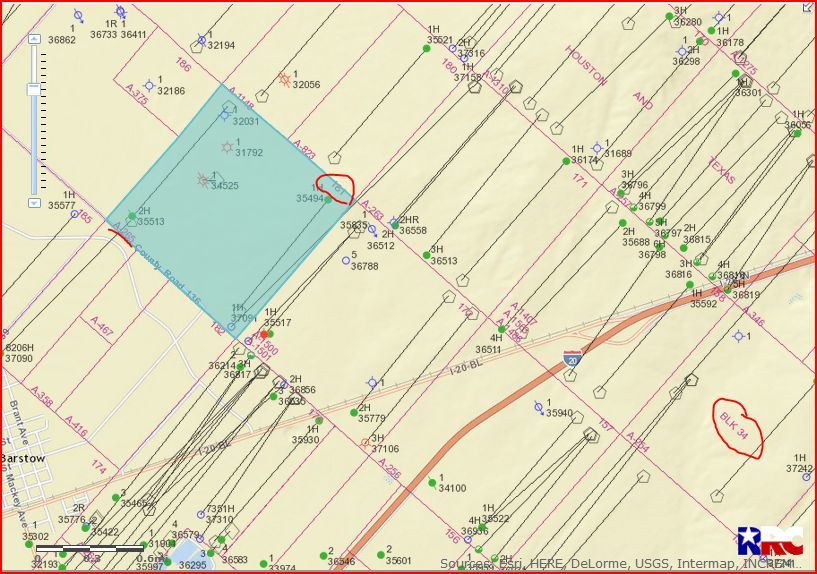
Ward County. Section 181 Block 34 H & TC Railroad survey
I have no information about the wells & tanks on the land.
Good Morning Larry. On the GIS Map I see 1 dry hole, 2 plugged wells (1 gas-34525, 1 oil-35513), an older gas well-31792/completed 1979/Exxon Corp), 1 producing oil/gas well-35494, and 1 permitted location/37091/February 17, 2017/Anadarko E & P Onshore LLC/Operator # 020528. I see no spud date (begin drilling) on approved location 37091…so don’t know if this well has been drilled. Anadarko is definitely the Operator you would need to contact.
GIS Map of Ward County. Section 181/Block 34/A-265:
CLICK ON MAP TO ENLARGE
Contact info for Anadarko:
ANADARKO E&P ONSHORE LLC 20528
ATTN FRANK A. DAVIS
PO BOX 1330
HOUSTON TX 77251
(832) 636-3130
Per your deed, you acquired E/2 of SE/4 of SE/4 of Section 181 which is 20 acres. Section 181 contains 640 acres. Your tract is along the east side of the section from the corner. Looking at the RRC gis viewer and at DI maps and turning on the imagery base maps, there is a tank battery on Section 172 to south and a tank battery on Section 180 to the west. The lateral horizontal wellbore of Chevron 34-181 1H well parallels the southern section line in Section 181, but that well has its pad at the other end of the section. So I do not see any tanks or equipment on your tract in Section 181. When you are on the ground, it is very difficult to determine where the section lines are located as there are no signs. The sections are actually angled so that what you might think of as the SE corner is really the east corner of the section. This may have caused your confusion about the location of the tank batteries.
Certainly a lot of activity all over that area and possibly trespassing?
I have 3 easements: 1 pipeline easement which I just completed, 1 truck access, and 1 for a water line for a year’s time.
To me it looks like they drive to those holding tanks a lot. I’m not sure whose tanks they are yet.
Well, I contacted Anadarko c/o Frank Davis, sent a real polite letter stating my questions and concerns. Never got a call back or reply. Any suggestions?
Texasfile.com is an excellent website for viewing documents that have been filed in Texas such as leases, easements, right of way, surface use agreements, etc. The Texas Railroad Commission has information on drilling permits, maps, pipelines, minerals, etc. You might find some useful information on the websites. You might also want to go back and read your land deed from when you purchased the property.