Hello. My name is David Christopher Davis and I am the son of the late Richard H. Davis. In 2009, just before my father passed away, he deeded his mineral properties to me. All of them are in Oklahoma except 16 tracts of land, 1786.55 acres, in Kent County TX. The "exhibit" appended to the deed is five pages long. I don't see evidence in any current leases of this property being active, and I don't pay taxes in the state of Texas, but I wonder if anyone can help me determine what, if anything, is going on in Kent County in mineral activity that might concern me. Thanks! David C. Davis
David,
Welcome to Mineral Rights Forum. Can you tell me what the Abstract #'s, Block #'s and Section #'s are for your minerals in Kent County, Texas? If you can I will pull up the GIS Map and see what's in the area.
Clint Liles
Clint: Thanks very much! These property descriptions are different from what I'm used to seeing for Oklahoma counties. The 16 tracts are described separately. I will give you the full description of the first tract and then whatever I see in the way of Abstract #s, Block #s and Section numbers in the other tracts. "FIRST TRACT: All or Survey No. One (1) on the waters of Croton Creek, a tributary of the Brazos River, about 15 miles N. 54 deg. E from Clairemont by virtue of an affidavit made by T.E. Murdoch, before the county judge of Kent County, July 31, 1895, under an act for the benefit of actual public lands, approved May 26, 1873; described by field notes as follows: BEGINNING at a stone mound which is 148 varas South of a rock mound made for the S.W.corner of Section No. 436, Block D, H & TC Ry Co.; Thence W. 950 varas, crossing Cottonwood Creek and Canyon, to a stack and rock mound from which a mes, #" bears, S. 1 and 1/2 deg. E 19-7/10 varas the NE corner of this survey; Thence W 950 varas, to a gyp rock for the N.W> corner of this survey; Then South 950 varas crossing canyon to a stone mound for the S.W. corner of this survey; Then East, crossing Cottonwood Creek and Canyon 950 varas, to the place of beginning, containing 160 acres of land."
That's so different from what's on my Oklahoma deeds! I see that it refers to Section 436 and Block D.
SECOND TRACT: Block L; THIRD TRACT: no section # or block # listed...
Actually, looking through all the tract descriptions I do not find Abstract, Block or Section #s for each one , mainly descriptions of surface topographic details. My father talked with me often about the Oklahoma holdings but did not tell me about these, in Texas, so I'm not sure what they mean now. I wonder if the court house there can tell me how to understand these descriptions in more familiar terms? Thanks -- I appreciate your help! David C. Davis
David,
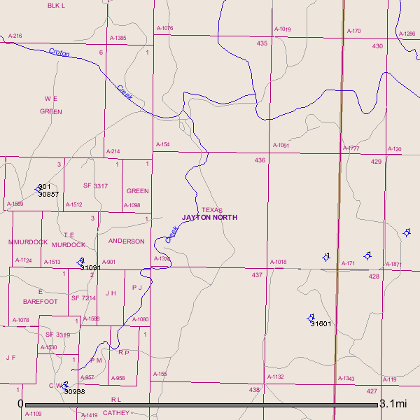
I see on the GIS(Geographic Information System)Map where numerous dry hole have been drilled in this area in the past and no producing wells are found. The Abstract # to your Section 436 is A-1376. Including a link to a dry hole that was drilled in 1997 to the S/E of your Section 436--API(American Petroleum Industry) # 263-31601:
GIS Map of Kent County A-1376/Section 436/Block D and surrounding area:
Clint Liles
David,
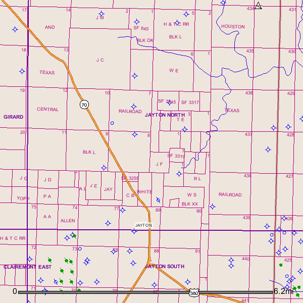
Block L is next door to the west of Block D. Without the Section or Abstract # I am unable to go any further with my search. Also numerous dry holes have been drilled in Block L. Several plugged oil wells show up on this map to the S/E and S/W(Green dots with sticks running through them. Blue circles with 4 sticks are dry holes.
GIS Map of Kent County Block L and surrounding area:
Clint Liles
Clint, thank you very much for this information, and for these useful maps. I've printed this out and will keep it with the deed. I appreciate knowing the value (not much, I guess!) of my mineral rights holdings in Kent County, and I'll convey this information to my uncle, John Michael Davis, who I assume has the other half of the mineral rights in Kent County, all the Davis family mineral rights having been divided between him and my father when my grandmother passed away. They were all purchased by my grandfather in the late 40's. Not surprisingly, I haven't had any offers to sell these rights in Kent County, but I suppose if a company were simply expanding mineral rights holdings in Texas it might make sense to entertain an offer. Thanks again -- David
Clint Liles said:
David,
Block L is next door to the west of Block D. Without the Section or Abstract # I am unable to go any further with my search. Also numerous dry holes have been drilled in Block L. Several plugged oil wells show up on this map to the S/E and S/W(Green dots with sticks running through them. Blue circles with 4 sticks are dry holes.
GIS Map of Kent County Block L and surrounding area:
Clint Liles

