I am VERY new to this and am not sure where to begin. If this question should go somewhere else, please point me in the right direction.
When I was poking around an Oklahoma database, the following results were returned:
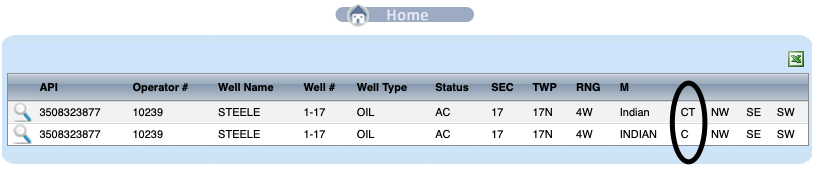
3508323877 10239 STEELE 1-17 OIL AC 17 17N 4W Indian CT NW SE SW
3508323877 10239 STEELE 1-17 OIL AC 17 17N 4W INDIAN C NW SE SW
I understand all of the fields except the last 4. I think they have something to do with quadrants, but I don’t know how to interpret them. Plus the “C” and “CT” make it worse. It is not clear how the following notations would translate into these fields: (W/2 E/2 SW/4) I know that this means “west half of the east half of the southwest quarter.”
The surface location is the center of the Northwest Quarter of the Southeast Quarter of the Southwest Quarter. Draw a square. Divide it into 4 equal quarters by drawing a line north & south & one east & west so you have 4 quarters of equal size. Do it again in each of the 4 quarters. Now locate your acreage & where the surface location is.
I understand about how the quadrants work. But I don’t see how the four fields at the end of the boulder lines work. CT NW SW SW. Where would this be in the map of the section? What does the CT mean and where does it go on the map of the section?
Read the description backwards. Start in the SW quarter. Then the Southwest quarter of that square. Then the Northwest quarter of that square. Now to the center of that square.
I have no idea what “CT” means and not sure where you are finding that as it is not on any of the Permits or Completion Reports. Yes, “C” means center of.