Greetings Everyone;
Last December I was surprised to discover my father(deceased) had purchased several hundred acres of mineral interests in 1950. Dad was a landman who started out with Carter Oil before WWII, so I was at least a little familiar with 'normal' lease agreements when I was sent one.
The question I would like to ask is "where is it?" because all I have is the description of "East 3/4 Section 30 and Section 19, Block 32, Township 1 South". Google doesn't understand such descriptions *smiling*.
While I have been under the assumption that having signed the lease it is now simply a waiting game, until a well comes in, my sister has been contacted by several companies seeking to buy her interests. The latest offer was $42,000.
Since there has been no production as far as I know, this makes me wonder 'what's up'?
Does anyone have wisdom and insight they could share to enlighten my ignorance, please?
Sincerely,
Sue Ann Edwards
There are some very good wells being drilled in Howard County right now and the fact that you are leased and your sister is receiving purchase offers are indicators of future potential for your area. From your description I believe your mineral interest is located a few miles south of Big Spring, TX near Highway 87. Most of the activity has been just east of your area but it could move your way.
Lots going on out there, DO NOT SELL!!!!!
Sue Ann,
This link is to the Howard County Group. Join and find out what's going on in the County.
http://www.mineralrightsforum.com/group/howard-county-tx-oil-gas
Clint Liles
Sue Ann,
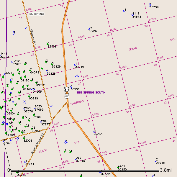
After further searching I find a well(API # 227-37916)has been drilled about 1 mile south/southwest of your section 30 in A-653/Sec 36 in April 2014.
http://webapps2.rrc.state.tx.us/EWA/drillingPermitDetailAction.do?methodToCall=searchByUniversalDocNo&universalDocNo=488368055&rrcActionMan=H4sIAAAAAAAAAL1QwU7DMAz9mnGMknTtxsGHCsGZjYkdqh2y1uoipU3lpAKkfDxuEdLoOO-U5-eX52cnJSXopKQC9UBUl3W0vt_X1FTyBDP_gWczDEELbosQTUQRP8UYVlm5lazQsNIvz8eSYTbBhqxztm9fkTobw25E-vqxFY1n0Ro6jBffHPyTcY6JHAjjSP3Bv6Gh-sLUFuRNmirM3ZLaIAZDpns3bsQ5JGfQepNtHlUxVTmcsbV9ONo4mbHbn1rpRX2tX4xV9ztC-F2-gMG0SFdL_nsRdaqWuiksqKRByZQxWINMOb8FE7e_73LPbwmpeaJhAgAA
So activity is not too far away. Numerous producing oil wells and plugged wells are in the surrounding area of your minerals. Try to be patient.
For your information Section 30 is also Abstract # 1226 and Section 19 is Abstract # 161.
GIS Map of your Howard County Sec. 30/A-1226 and Sec 19/A-161 and surrounding area:
Clint Liles
