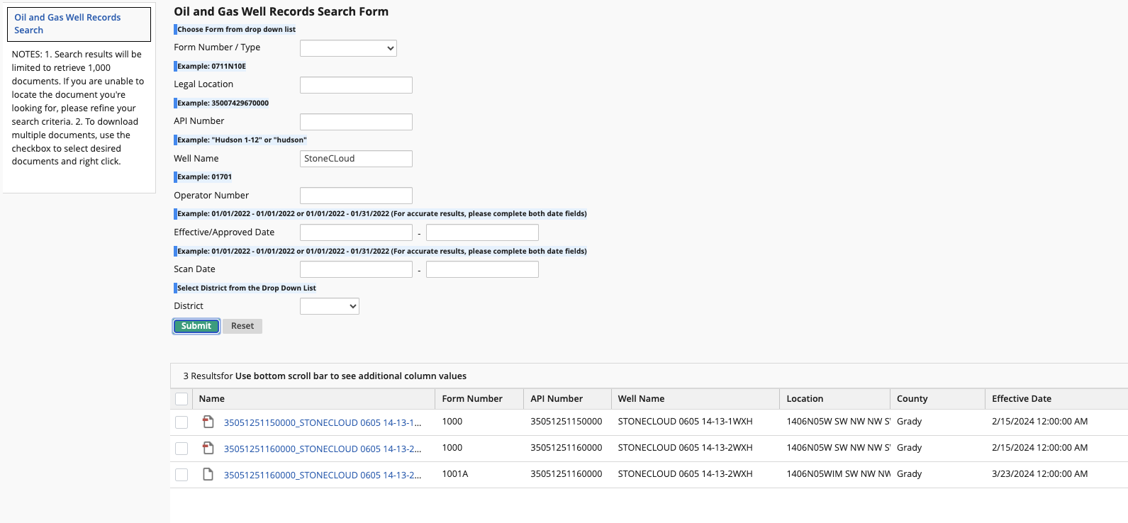
I was wondering this may be a silly question but if they do drill three horizontal wells will they complete all three before it goes on the Okla. Tax site you were referring to that you watch? Or will they post individually? Vickey
It depends. Each well will be listed individually by name on the OK well records site with permit, spud, completion and found by their surface location. The OK tax site will list by name when they become active because the state wants their taxes! If the same company is drilling both wells, they usually finish both and turn them on pretty close in time together. It saves a lot of money to do the frac jobs on both at the same time.
2 Likes
Thank you for that information. I think if the first one goes well there will be 2 more drilled, a total of 3. Time will tell. Also, they seem to be drilling in an odd direction according to the picture on the exhibit that was filed. Vickey
I noticed on the site it shows 3505125116 STONECLOUD #0605 14-13-2WXH and
3505125115 STONECLOUD #0605 14-13-1WXH then reads 1 of 3, 2 of 3. Does this mean they have done 2 so far and still like one more total 3? Or is this just what they plan to do but have just done one so far? Thank you. Vickey
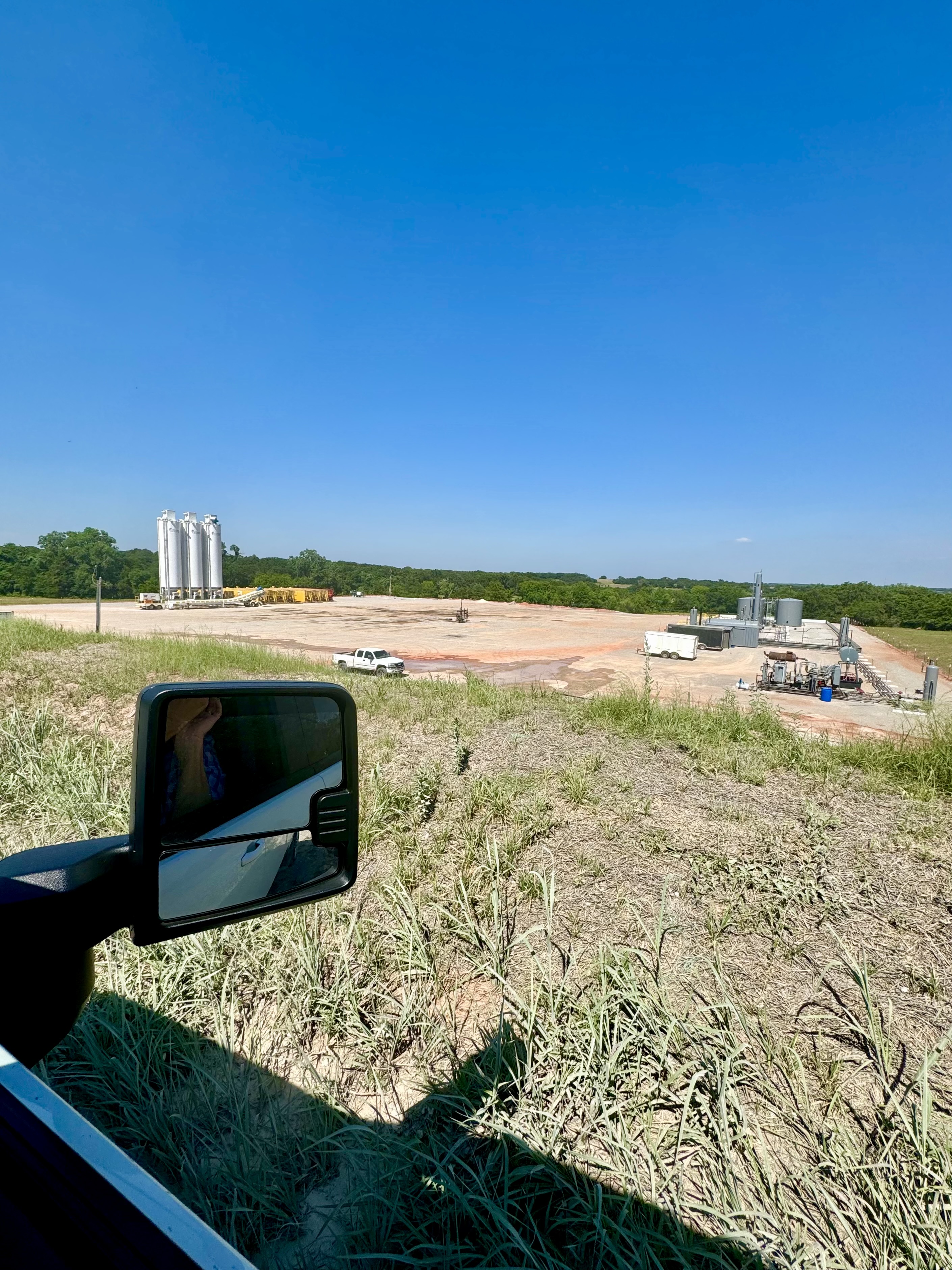
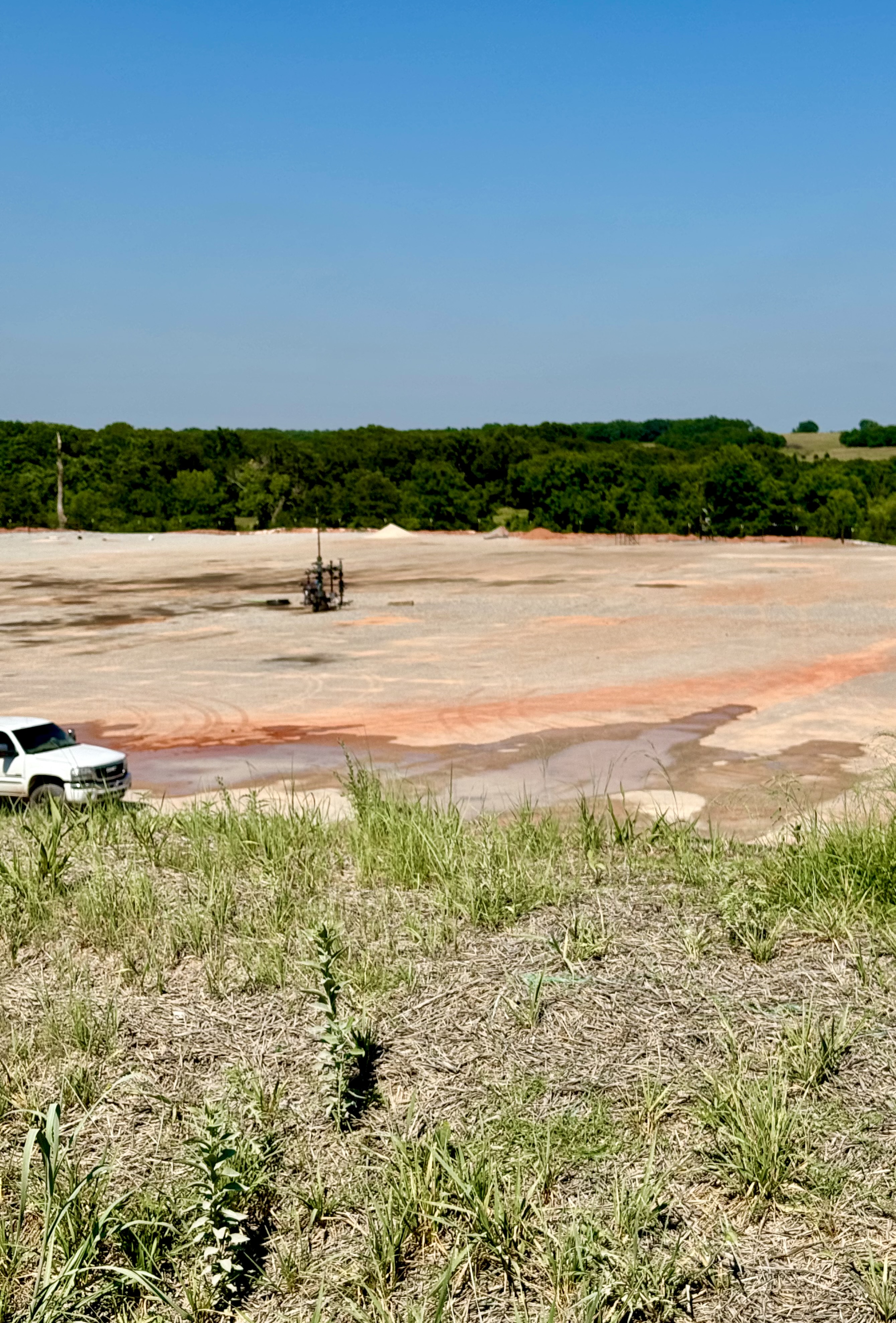
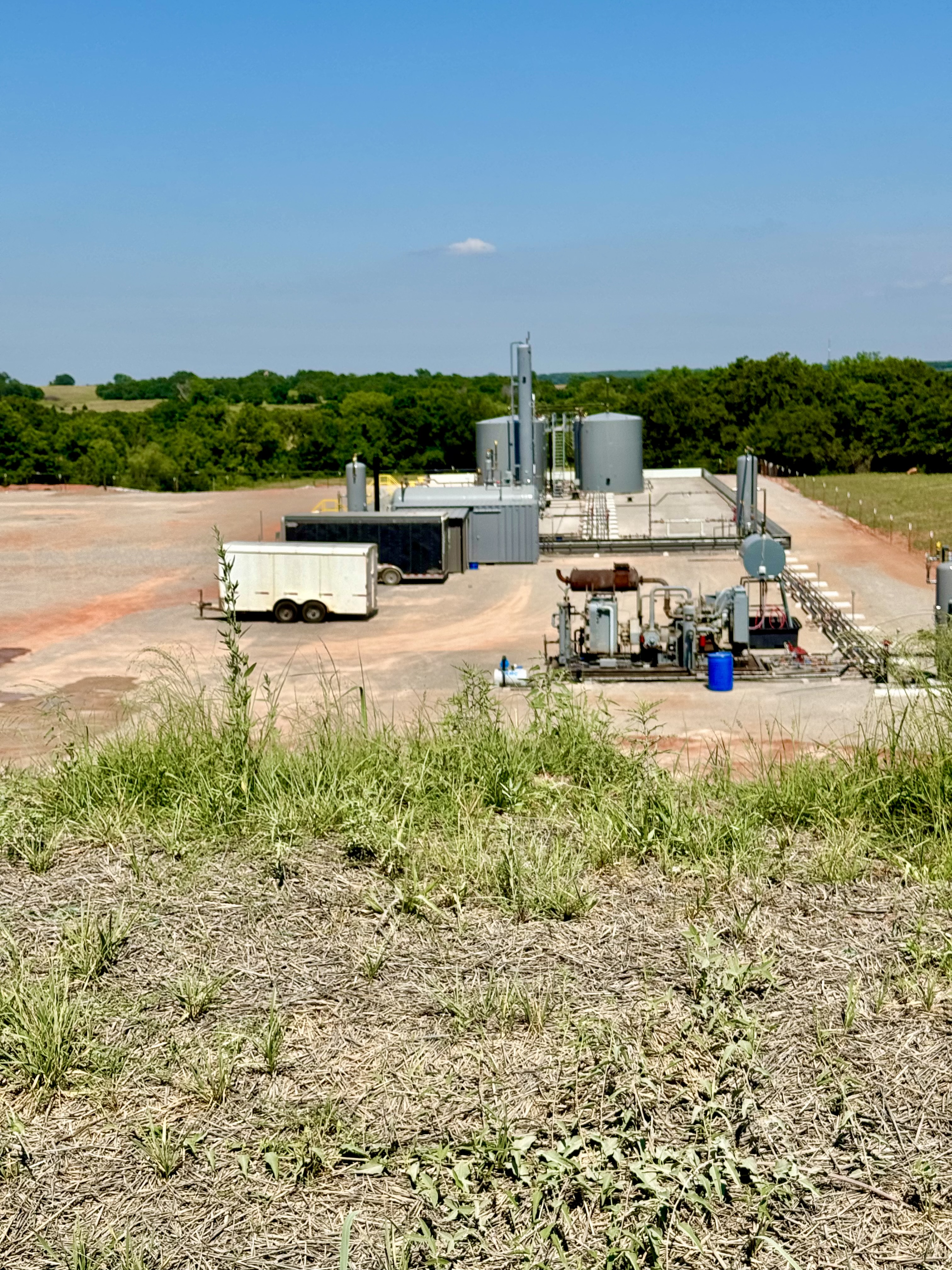
Hi Don, I was wondering if you could answer a question for me. I found the well location of 14 6N 5W that you took the picture of for me > CD2023-001389 and 1387 I believe, now I notice the drilling rig is gone. I was told the second well was being drilled and I was trying to see the location of the second. I believe there will be three and all in 14 running through 13 to the bordering boundary of McClain Section 18. Tried looking at the map and according to it they appear to be side by side in 14 spaced apart of course. But will I be able to see the next two or will I not due to another section blocking the East side of 14? I’m still learning all these things thank you so much for your help. Vickey
Not sure what is going on Vickey. The rig was still there last time I was by, but that’s been a few weeks. Give me a couple of days and I will go by there and see if there is any activity. I only see one spud report, but those are not always timely filed. I am watching another well being drilled and no spud report has been filed to date that I have seen. Been almost 6 weeks on that one.
According to the Enverus rig tracker, the rig is gone. Stonecloud 0605 14-13-2WXH was spud. No notice for the #1 well posted yet. No frac notice for the #2 well that was spud.
M. Barnes, so does that mean they did in fact drill 2 wells? But we know nothing more about them yet? Meaning whether it was a dry hole or what? I saw 1 well drilled, don’t know what to call it, but it was sticking up out of the ground and tanks were present. The rig was gone but I couldn’t see where the second well was drilled. They showed possibly 3 going in but I was on the west side of 14 looking east; that is where the rig was set up. I wasn’t sure if the second well was farther east and just couldn’t see it, maybe only one side of entry but I’m not sure. I know they were running them through 13 which ends at Section 18 McClain County. But they were running the horizontal lines an odd direction according to the wells’ direction around them and the map unless I’m really confused and that is a possibility lol. Thank you, Vickey
Thank you, Don. I was on the west side of 14 looking east; that was where I saw the rig. Then it was gone and I saw a wellhead sticking up out of the ground and tanks set up. I couldn’t tell where the second one was going if it was farther east. I may be turned around but I thought they were running the horizontal wells an odd direction according to the wells around the area on the map. And I believe their plans were to drill 3, but if the rig is gone and not just moved to the third location, they may not. But I can’t find the second well so not sure where the third would be lol. I guess first is to make sure you know where to look lol. I saw the sign posting the direction to the rig where we turned north, but is there only one side of entry to 14/13? Thanks and there is no hurry. I just like to see it happening and I’ll probably go again just to see the wells. Thank you again, Vickey
According to public data, only one of the wells was spud and it was the #2. It has not been fracked yet according to fracfocus.org. May have only set the surface casing.
Martha, I followed your instructions and looked up the new Blue Mesa wells on the OKtap.tax website. I found four wells that have active dates of 06/11/2024. I know this is too recent to show production, but doesn’t this mean it is producing? Thanks for all your help!
Yes, the Black Mesa wells are now listed as active, so amounts will show up in about four - five months.

Thank you, Don. Is this the same location that you took pictures of before for me? Or is this a different location? If it’s the same, then just one well so far? Wonder where the second one will go if they do in fact dig a second one. Said they would dig three, but guess we will just have to wait and see.
Same location as the other pictures. Just the one well for now. The drilling permit for the other well has them 15 feet apart, which seems pretty close. Not sure why they didn’t drill both wells before installing equipment, or even the third well. I have a section that I have been waiting on for almost 8 years for the second and third wells, which are now being drilled.
Don, did you notice the direction of the wells according to the map? What I saw is completely different than all the wells around. I was told they were starting to drill the second well. It appears the wells are being drilled North-South and the others are West-East if I am reading the map right. Well, guess I will just have to wait. I was told they have until August to complete the wells. Thanks Don again, Vickey.
In my opinion, you haven’t been told correctly. Your section is what we call a “bastard” section as the sections both North and South were not available. The wells that drill perpendicular to the formation beds work best because the frack can go further into the natural fractures of the formation. The only choice was to go East and West. That is not the optimal direction but the operator is trying to salvage their leasehold. And there isn’t a timeline on completing a well. You are correct that you’ll have to wait another 6-8 months before you can cash the checks. Patience.
Thank you, Todd, for your help. Am I correct in saying they are running it North-South instead of East-West? Or am I reading the map wrong? Yes, I was told a second was starting and three were expected and according to the courts they have until August 24 to complete the three. This is what I was told.
I just wanted to give you a little update. Well, big update. It looks like the hearings on the Cassillas wells finally took place this morning! They’ve been approved for three two-mile long wells. The docket entry will show that the hearings have been continued to 8/2024, but I wanted to put your mind at ease that the continuation is for administrative purposes only. You’ll notice that the court entry shows the merits were recommended, which means that the judge approved their request and will issue an interim order, but the final order will not be issued until after the wells are drilled, which they estimate to be in August.
Final orders are not issued until the operator submits the perforation intervals (footage in each section) to the Commission. The August 24 date is for administrative purposes only. It can be continued at the request of the operator or can be dismissed by the operator. As I mentioned in another post by Mr. Bray, the drilling of the STONECLOUD 0605 14-13 2WXH was completed on or about May 5. Sections 13 & 14 lay east and west of each other (13 being East of 14) so these wells are being drilled in a predominately East to West or West to East direction, depending on where the surface location is. The #1 well is at the southern end of the 2 sections. The #2 runs across the center of both sections and the #3 (if drilled) will be at the northern end of both sections.