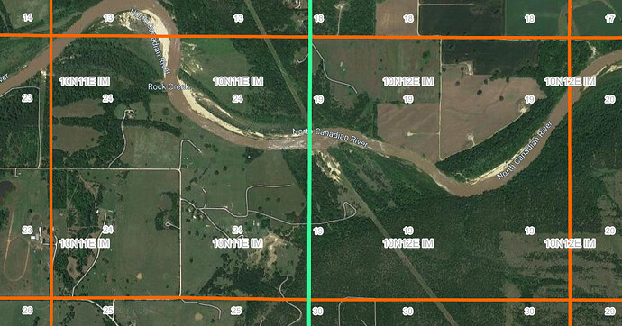
We are looking for the address or a narrowed down area of where our mineral interests are located. We have relatives in the cemetery on the property and would like to check it out. Any information on how we can get a ballpark area of the address so we can visit it in the future would be great. Thanks The descriptions are both in Okfuskee county, Ok. 24-10N-11E 19-10N-12E
That should be somewhere near here: Google Maps Good luck on your search!!
https://okmaps.org/ogi/search.aspxThat is a great map. Here is one with the highways on it. Okfuskee County Map.pdf (379.1 KB) Use the sides to locate the townships (N-S) and Range (E-W). The sections are ordered 1-36 starting in the top right corner of the township and then going in a serpentine fashion 1-6 right to left (east to west) , then 7-12 left to right (west to east), etc. until you get to 36 in the lower right. Your locations will be in two different townships, but the sections are right next to each other as shown in the Google map.
Thank you, you were so helpful, I appreciate it.
Thank you, I love this website for knowledge sharing people like yourself.
Search by Section, Township Range. Launches Google Earth
There is another source , messy to use but very detailed maps: https://store.usgs.gov/filter-products?country=US®ion=OK&sort=relevance&lq=dustin This is the USGS store. You can view maps for free or buy . These are “quadrangle maps”. I see a cemetery marked in sec 26 10N 11E but none in the sections you mentioned. Sec 26 is the section directly south of 23. The map was field checked in 1967 so is very out of date , this may be an advantage. Mike NB: They are slow filling orders but they do arrive.
This topic was automatically closed after 90 days. New replies are no longer allowed.
