My research shows there is little activity in this part of New Mexico. Can anyone shed light on how many wells have been drilled in the past year or two?
Thanks in advance, Jim W.
My research shows there is little activity in this part of New Mexico. Can anyone shed light on how many wells have been drilled in the past year or two?
Thanks in advance, Jim W.
Map shows all wells spud in the last 2 years. Tract in yellow. Nothing near there.
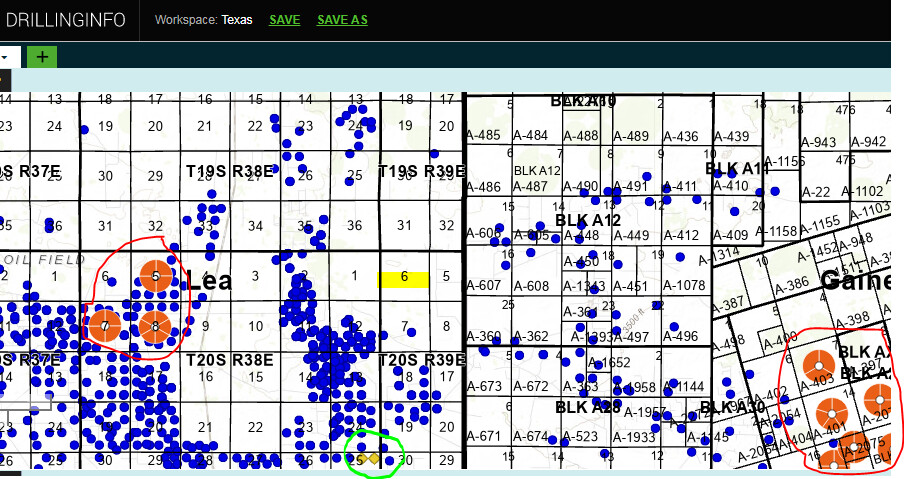
This is another way to look at it. Blue dots are existing production. Orange pies (circled in red) are leases in the past 12 months. Yellow diamonds (circled in teal) are drilling permits. You’re currently in a dead-zone. Hopefully that will change in the future.
The maps are very interesting. Would you please share the sources? Even if it requires some costs, that can be valuable info. I assume that the property is right on the border with Texas.
I subscribe to Enverus (formerly Drilling Info). If you only need one County it can be very reasonable. I need the whole country and pay about $20,000 (ouch).
A few years ago Drilling Info was offering a free 1-County subscription to NARO members. Don’t know if it still does.
Section 5 to your East is on the Gaines County, Texas line.
I own 160 acres in Township 17S Range 39E that like yours is in a production wasteland.
Is this in the Hobbs area?
Hobbs is approximately the southerly part of Section 34 in Township 18-38.
Hobbs is north of these minerals.
Go SOUTH on HWY 18 out of Hobbs for about five miles - I think it’s that far south on the east side of HWY 18.
We’ve made that drive numerous times in the past six/seven years.
We are currently living in San Angelo, Texas - caring for my 95-year-old Mom.
This topic was automatically closed after 90 days. New replies are no longer allowed.