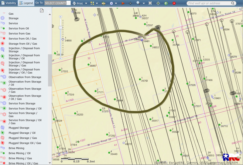
Harrell 33, Howard County. We own property and also mineral rights in Section 33, Block 33. I often check the RRC Public GIS Viewer. Today I noticed what appears to be new horizontal well lines going right through our property. What does this mean for us? Wells are still labeled as permits.
The permits in Township 3 North, A-350?
I am not sure I will upload an image
Ah, Township 2 North, A-334.
These were very recently approved permits (1/4/21) for 2.5 mile long wells in the “Brutus Buckeye 28-40” unit, so the Harrell 33 acreage would likely have a 20% allocation of the royalties (160 acres / 800 acre unit). plat.pdf (159.8 KB)
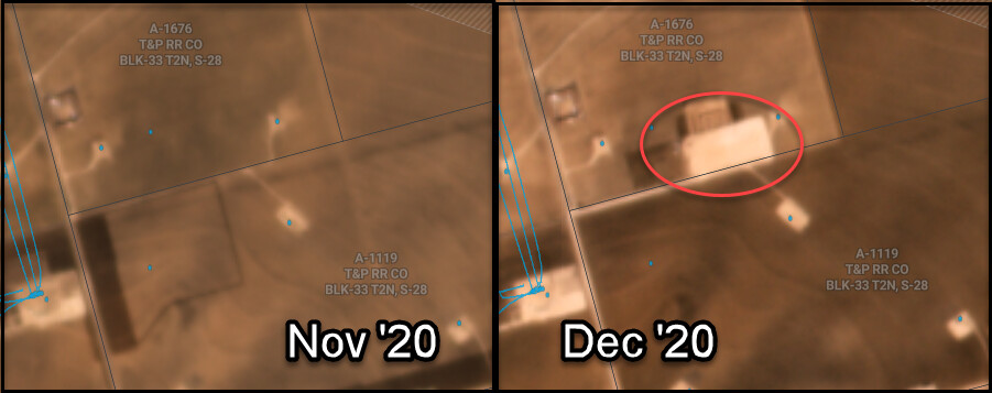
Have you received any correspondence from Birch Operations? I can see on satellite they’re clearing a pad to prep for possible drilling as of Dec 2020. That’s a good sign at least one well will be drilled soon (although my last company had 30+ pads we built and never drilled…). No wells have been reported as spud so far.
Wow thank you so much for this info. We have not heard anything from Birch yet. I am new at all of this. Will the operator on these be Birch?
Yes, Birch Operations was the operator who filed for the permit. As there is a producing well on your property, they already have a lease established (which will apply to these wells also), so the next step should be sending you correspondence regarding the unit being formed and your acreage pooled into, and there should be a division order sent your way that should spell out your pay decimal for you to check and approve. The lawyers/landmen in here can comment more on that part of the process.
Thank you so much for your help. I am sure we will be hearing from them soon.
Yup! As long as they have your current address, you should be hearing from them!! Congratulations on the activity ![]()
Hi Tracy, do you have any idea why we have not received division orders yet? I read that 15 business days from the permit approval was required.
You’re receiving payments from Birch for the existing wells, correct? As in, they have your current address? If so, I’d send an email or call whatever number is on their correspondence/statements to inquire about the permitted wells. They’d have the most information about it, although how much they’re able to share through owner relations is unknown until asking. Some departments are super helpful fountains of information… and some are not…
Yes that is correct. I will see what I can find out. I did see that there was already some spud activity on the Shale Expert site, not sure if that is correct.
Division orders are generally not issued until after the well has been drilled, frac’d and is producing.
Thanks I read this on the Permit Notice Requirements and thought we should have received notice by now. We own the land and the royalties. Per H.B 630, signed May 8, 2007, the operator is required to provide notice to the surface owner no later than the 15th business day after the Commission issues a permit to drill. Please refer to subchapter Q Sec. 91.751-91.755 of the Texas Natural Resources Code for applicability.
I have been learning much about Mineral Rights and land ownership the last 2 years. Our mother and uncle both own land and royalties. I was promoted to get involved when there was a problem with a deed when a new operator was on the well. They stopped receiving royalty checks for quite a while, so started researching and found 2 operators on the Oil and Gas Data Query. Production numbers were low during that time. We did contact the operator SM Energy and they said they only owed $1.37, found that strange. Current operator has been great so far.
Do we need to worry about the new horizontal wells on an old lease?
1 Like
DonnaL
If I’m understanding right, your acreage is the 160 acre tract called Harrell 33. According to the plat for the proposed wells called the Brutus Buckeye 28-40 that Tracy was referring to, Birch Operating got permits approved to drill a total of 13 horizontal well bores based on 6 wells each planned to have two stacked laterals and one single lateral well. Tracy sent you a plat earlier that showed the location of several of those laterals. The plat attached below is for the last lateral that Birch permitted, called the 7WA, which is further to the east, but the plat also shows the designed path of all the wells.
The point I think you may be confused about, and probably why you haven’t been contacted by Birch, is that the drill site for all of those proposed wells isn’t on your property. The attached plat shows the drill pad is in Section 28 that is north of you rather than in Section 33, and there is another 160 acre tract called the Beall 28 between your property and that drill site.
Also, the permits for the proposed wells say they are being drilled as allocation wells rather than as part of a pooled unit. With allocation wells the portion of production each mineral interest is entitled to is determined through an allocation formula that may be based on the number of feet of horizontal well bore that crosses each mineral interest divided by the length of the total wellbore, rather than being based on the number of mineral acres each royalty owner has versus the total number of acres in the unit.
Yes, so since you’re not a surface owner where the wellhead/pad is located, they’re not needing to contact you as a surface owner.
Any contact with you would be purely as a mineral owner.
At the very least, you should be given notice of the allocation once the wells are completed. You might review your lease language to see what terms cover combining units together (not in pooled units, but allocated), if any. Sometimes older leases leave out clauses that would be spelled out in more detail by a modern lease simply because those things weren’t as common 15+ years ago.
Do we need to worry about the new horizontal wells on an old lease?
Do you still have a copy of that old lease? That’s one of the harder things to get a hold of if a family member loses it over the years. I applaud you learning more about mineral ownership! Feel free to ask whatever questions you have!
We also own the surface, 1/2 of the 160 between 2 people. Yes, I have copies of the lease agreements.
I do understand that we do not own the surface at Section 28.
How do you look up the map for property that you own mineral rights on? Just found out family has mineral rights. I have the description, just need to know where to go to find. Also, how do you find if there are any leases on the property?