My non-computer savvy friend has 3 parcels in Pecos County with oil royalties. We live in Idaho and he has never been to or seen his land. I have found the county records with property ID and legal description but cannot get any farther than that. We are over 60 years old and would like to see these properties on Google Maps and find out how many oil rigs are there just for fun. One parcel is below.
Property ID: 10689
Legal Description: 8263 146 T&STL SEC 8SE 1/4 UND 1/3 INT
Geographic ID: 00146-00008-00600-000000
Can you provide the legal location? Section, Block or Abstract numbers? If the wells on the property are not too old the plat maps that are on the approved drilling permits will have the longitude and latitude.
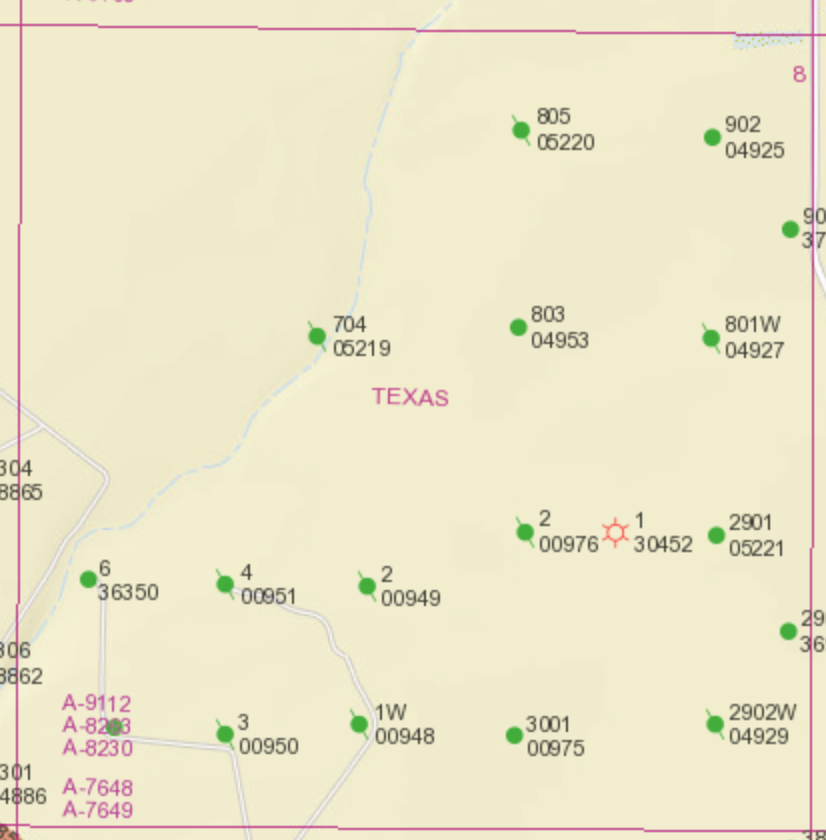
Each green circle is an oil well. The green circles with a line through them are plugged oil wells no longer producing. The red sun icon is a gas well. This is for the entire 640 acre Section and not specifically your tract.
Go to the Texas RRC’s map viewer http://wwwgisp.rrc.texas.gov/GISViewer2/ and click on the magnifying glass icon in the row at the top of the map. A drop down menu will appear. Choose “Surveys” and select “Pecos” County and enter one of the Abstract numbers above in the blank Abstract field. Click the “Query” button. Use the magnification bar at the left side of the map to zoom in and out from the highlighted parcel. Do this for each of the abstract numbers above, assuming this is the info you are seeking.
Thanks all. I have found the county records. Curt’s dad (William L Thomas deceased) shows 6 mineral properties and Curt Thomas shows 1 property but Curt is paying taxes on all 7. I guess we need to get ahold of the county to change the names over to him.
Question:
When I go to the GIS viewer and type in the abstract number for the properties, the map displays a whole section but will not break it down to an exact parcel. All I see is a whole section. According to the county record there are 2 80-acre parcels, 1 200-acre parcel, and 1 40-acre parcel, but I cannot figure out how to put in a more accurate description.
The tax bill I have here shows taxes due on mineral rights. But the Pecos assessor site shows real property… Land… It used to be AG but this year they changed it to Land Non-Homesite Value. The appraised values for the last 6 years have been about $600 on the 3 parcels. This year the appraised value is about $10,000.