Ginny… don’t see anything…
Grant: SandRidge Exploration & Production LLC; Joan Marie 2705 No. 2-20H Well; SW1/4 SW1/4 SW1/4 SE1/4 (SL) of 20-27N-05W; 1,436 barrels oil per day, 3,089,000 cu-ft gas per day; TD 9,840.
Ron: This morning you posted a well completion notice for Joan Marie 2705 No. 2-20H Well. In today’s mail I received a Division Order from Sandridge for this well and also a second Division Order for Joan Marie 2705 No. 3-20H well. I have not seen a well completion notice for the 2705 No. 3-20H well posted. Do you have any info on this? Thank you. Millard Wright
No info on 3 posted yet.
Grant: SandRidge Exploration & Production LLC; Joan Marie 2705 No. 3-20H Well; SW1/4 SW1/4 SW1/4 SE1/4 (SL) of 20-27N-05W; 1122 barrels oil per day, 1,164,000 cu-ft gas per day; TD 9,674.
Ron: Thank you very much for posting the well completion notice for Joan Marie 2705 No. 3-20H Well. Millard Wright
Grant: SandRidge Exploration & Production LLC; Harold 2506 No. 1-34H Well; SW1/4 SW1/4 SE1/4 SW1/4 (SL) of 34-25N-06W; 406 barrels oil per day, 511,000 cu-ft gas per day; TD 10,280.
SandRidge Exploration & Production LLC; Herbert 2805 No. 2-19H Well; NW1/4 NE1/4 NW1/4 NE1/4 of 19-28N-05W; 1,061 barrels oil per day, 2,216,000 cu-ft gas per day; TD 9,629.
Can you pin it down a little more?
I was able to search the whole County and found no leasing or filing with Oklahoma Corporation Commission for wells in the name of Red Fork.
I checked another source I had for Grant County and did find some leasing for Red Fork. I could check a Section Township and Range if I had it.
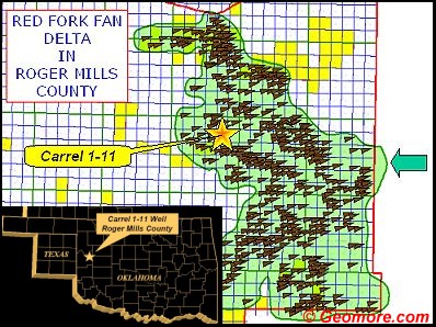
RED FORK IS OIL BEARING
Red Fork Sandstone of Oklahoma: Depositional History, Sequence Stratigraphy and Reservoir Distribution Richard D. Fritz, American Association of Petroleum Geologists; Edward A. Beaumont, TriOks Exploration, LLC; Larry D. Gerken, Newfield Exploration, Tulsa, OK.
The Middle Pennsylvanian Red Fork Sandstone formed as a result of progradation across eastern Kansas and most of Oklahoma. It is one of several transgressive-regressive sequences (cyclothems) developed within the Desmoinesian “Cherokee” Group. Sea-level changes together with varying subsidence were dominant factors controlling the general stratigraphic (correlative) characteristics of the Red Fork interval. Progradation was episodic with sand deposition in the more active part of the basin during lower sea-level stands and valley-fill deposition in the more stable areas during sea-level rises.
The Red Fork was correlated, subdivided and mapped using data from more than 27,000 wells. Maps of Red Fork sand trends reveal a fluvial-deltaic complex covering most of Oklahoma. The Red Fork consists primarily of undifferentiated alluvial-valley and plain (fluvial) bodies in the northernmost part of Oklahoma, fluvial-deltaic bodies in most of the remaining parts of shelf area and off-shelf submarine-fan and slope-basinal floor complexes within the deeper part of the Anadarko Basin. The basinal facies can also be interpreted as low-stand deltaic deposits.
The Red Fork appears to represent one Vail-type third-order sequence. It can be divided into at least three parasequences which for the purpose of this study are called upper, middle and lower. Each parasequence represents a transgressive-regressive episode often separated by thin regional limestones or shale markers. Correlation of these parasequences is relatively easy from the lower shelf to the basin, and more difficult on the upper shelf.
The provenance for the Red Fork was most likely an extensive drainage system to the north and northeast of Oklahoma. This drainage system probably extended as far as the Canadian Shield or even Greenland and appears to be subparallel to the Midcontinent Rift. A secondary source for the Red Fork was the Wichita-Amarillo Mountains in the south.
Much of the oil and gas has been trapped in stratigraphic traps, and a significant amount of oil is in channel sandstones and trends at high angles to the structural grain. The Cherokita-Wakita Trend, South Thomas Field, East Clinton Field and Strong City Field represent excellent examples of facies and reservoir development controlled by facies distribution and related diagenesis.
Grant: Fairway Resources Operating LLC; Lebeda No. 2-12H Well; SE1/4 SW1/4 SW1/4 SW1/4 (SL) of 12-28N-06W; 510 barrels oil per day, 1,474,000 cu-ft gas per day; TD 9,573.
Red Fork picked up some leases no well information. Most in 2012 or before.
I have property with mineral rights in Grant County, Section 1, Township 26 N, Range 3W of I.M. Is anybody getting offers for 3-year mineral exploration leases? What prices are offered for mineral leases?
John, No leasing activity in that area.
Grant: SandRidge Exploration & Production, LLC; Geiser 2507 No. 1-25H Well; NE1/4 NW1/4 NW1/4 NW1/4 (BHL) of 25-25N-07W; 311 barrels oil per day, 241,000 cu-ft gas per day; TD 11,164.
My name is Troy Curtis, a landman with Concho Land Company in Freedom, Oklahoma, as well as Oklahoma City. I thought while times are slower, I would offer to help with any questions people may have in general and post my email, conchojobs@gmail.com, for any and all questions. I also wanted to offer our services for individuals in need of mineral research or help with production-related concerns in all Oklahoma counties and the surrounding states.
Anything going on near Section 32 in Grant County? I have mineral rights leased in Section 32. Thanks.
Mineral owners:
www.okenergytoday.com provides daily Completion Reports and Permits to Drill on the left-hand column under the same name.
All other well information for your county including Spud Reports, ownership changes, permits to re-drill, etc., can be found under Royalty Owners Corner, also on the left side.
If you wish to subscribe to our free Daily Email Newsletter, click on the Subscribe button.