Thank you. Merry Christmas.
1 Like
Hi Robert… refresh my memory about which document we are talking about? Thanks!
The Dansil 1 completion report. Also, do you have any information on Camino’s withdrawal of its request for a horizontal well of the Dansil 1 well?
Hi Don, Have you heard of Mutual Mineral Partners? My two cousins who still own 1.5 acres each in 12-6N-7W told me they recently received a lease bonus for $3000/net acre from them. I don’t know the % royalty. We didn’t do that well with Triton Energy.
Robert, if you haven’t already gotten a division order for the Dansil, you should soon. Looks like the well was transferred to Camino, so I believe they will be sending you the division order. I see a Permit to Drill for Camino to drill another well in Section 10, but this time going north into Section 3. That permit doesn’t expire until December 4, 2020. So it may be a while on that one. The well name will be the OVERHOLSER 0707 3-10 1H.
1 Like
Hi Janet, As a matter of fact, I have heard of Mutual Mineral Partners. They were wanting to lease my brother over a year ago, but for some reason it didn’t happen.
I will give them a call next week and see if there is any interest. Thanks!
I need advice on Garvin County Section 36 Township 1N Range 2W. The question I have is: Red Sky is wanting to take the 2-year extension offer in contract made with my mother. She passed away October 3, 2018. The will is in the process of being probated. They want us to set up a trust so they can pay us. Does the contract have to be honored and has anyone else set up a trust just for a certain royalty? If so, do you advise us to do that? Thanks.
An attorney can answer that question better. How the will is worded may determine what you should do. You may not have to set up a trust if the will says the minerals go to particular people. In the meantime, Continental is leasing that section like crazy. When was your mother’s lease term up for the first three years?
Thanks for the information. March 14, 2020.
Does the original lease have the option terms listed? Bonus and royalty or can you negotiate a new one. You don’t have to answer until Mar 14, 2020. They just want to get it done.
Yes. The option is listed. Don’t see anything about a bonus.
I will try to attach a copy of the contract later today.
If your lease has a 2-year option included in the lease, it’s at the discretion of the oil company whether they want to extend the lease or not.
Then you probably stuck with what your mom got three years ago (or less).
They have already sent us a notice that they want to lease. Just wasn’t sure what our options were.
I am hoping someone better at reading legal land descriptions can tell me if the two parcels below contain the wells in question. I can’t tell if the wells listed are in the interest owned or not.
Interest owned: West 6.2 acres of lot 4 Section 12-8N-8W Well in question: Baker Brent, Wampler 1; API: 3505120440; 12-8N-8W Lot 2; and the SW/4 NE/4; and the W/2 SE/4 NE/4
Interests owned: W/2 NE/4 SE/4 and SE/4 NW/4 SE/4 and NE/4 SE/4 SW/4 of 20-6N-6W E/2 NE/4 SW/4 20-6N-6W Well in question: Marathon; Scout 1-20H; API: 35051238590000; 20-6N-6W SE SW SW SW
Going to walk you through how to figure it out.
Wampler 1-Go to the OCC well records site. Test Type in 1208N08W in the location box. Hit search. Note that multiple names come up for the Wampler 1 well. The API is the same for each, so there is only one well. Open Form 1002A which is the completion report. It gives a nice plat of where the well is located and also states that the spacing is 640 acres in the reservoir with the perforations. Therefore, any mineral acreage in that section would be included in the well spacing for that reservoir.
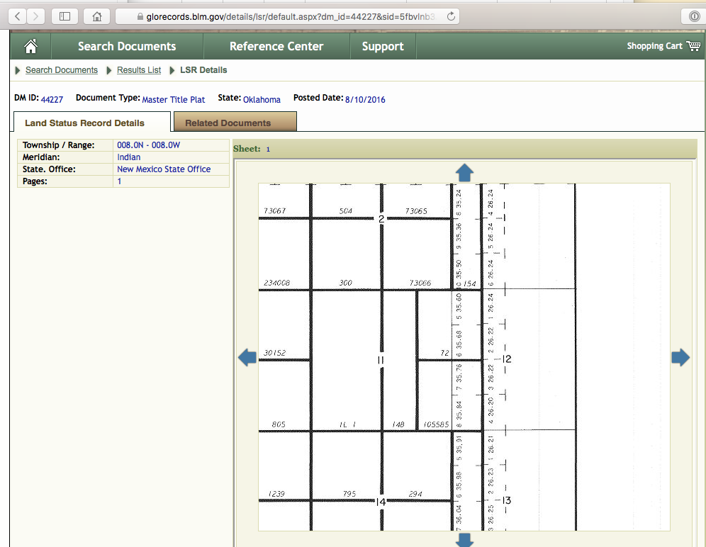
Now to the hidden question. Where are lots 4 and 2? The word “lots” is a clue that something is unusual in that section. The answer can be found by looking up the township in the Bureau of Land Management site. Search - BLM GLO Records. Pick LSR for the rectangular grid system for OKlahoma. Put in 8 North and 8 west and ask for the Master Title Plat. This gives the original surveys at patent and were done at statehood. Zoom in and you will find Section 12 has some lots on the west side. Lots 2 & 4 can be found there with their acreage.
Here is an article on how to read descriptions S-T-R Legal Land Descriptions in OK_Kletke-1.pdf (59.7 KB)
Scout 1-20H. Same idea. Type in 2006N06W into the location on the OCC well records site. You can see the Scout 1-20H well listed. The H in the name tells me that it is a horizontal well and likely to be spaced at 640 acres. I check anyway. This is a more modern well, so the format of the report looks a bit different. Scroll to page 2 and you will see that the well has a spacing of 640 acres. So any minerals in that section will be covered by the spacing in the Woodford reservoir.
This is incredibly helpful and educational. Thank you so much. I had looked at the completion reports but since I wasn’t sure what I was looking for, it wasn’t too helpful to me until you covered it for me. I also didn’t know where to find the original maps. Since you mention the lots, this property came from the Choctaw and Chickasaw Nations as part of statehood. They are handwritten land descriptions and as a result, the land wasn’t recorded correctly. There was no Grady County to record it in! Originals were hard to read. Section 12 got recorded as 15 and Section 20 was on a second page that was missed entirely. My ancestor had a one-page handwritten will that only referenced “the farm.” Interesting intersection of family and US history with Oklahoma being so unique in both ways. Thank you again.
Make sure that you do get the properties recorded correctly in the Grady courthouse.
Yep. I already have a note into them! Thanks.