How is “ownership interest” calculated in Oklahoma for horizontal well development?
What is meant by “distribution interest”?
We have a few mineral interests in the 27/8/4 area and have just received information from Gulfport. I am used to getting division orders from the operator but have not gotten any clarity from the operator.
Also, it seems the net mineral acres is divided by the entire Section 27 area or is it done on a lease or unit basis?
It depends upon the language for each well as to the spacing from the OCC case. Most horizontal wells in OK are spaced at 640 acres but not all. The royalty equation is:
net acres/ actual spacing acres x royalty x % perforations in your section upon the final drilling. Even though many horizontals go through two or more sections, they treat each section as a standalone for calculations (most of the time).
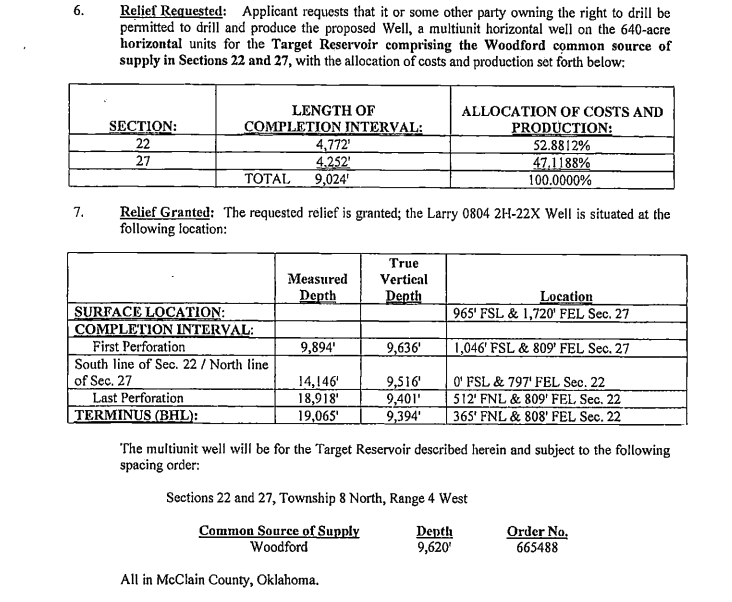
The final survey of the well will determine the percentage. You have quite a few horizontal wells in that section. Each of them will have slightly different final decimals since each of them has slightly different total lengths perforated in each section. The OCC will send out the splits for each well. For example, the Larry 0804 2H-22X was drilled in 22 & 27 back in 2018. Case 201804400 gives the final splits.
Thank you very much for the response. It is helpful! When I posted on the website I could not find a section on 27/4/6 or 27/4/8. So the confusion is my error.
I have a friend who just inherited the mineral rights from his father who recently passed.
I am looking for a plat map of his properties and the location of the wells showing how the well paths overlay (or not) his properties. In addition, we need the official document stating his ownership interest - something like a division order. The operator is Gulfport and they do not issue maps of any sort. There are five wells of interest.
He needs to see where the properties are and have confidence in the Ownership Interest assigned to him.
Can you point me in the right direction to where I could get the information?
@bweth, best guess is you are referring to the Angela 27x22x21x16h wells in 27-4N-6W Grady County. Plat of 1 well attached:
1DDA815D.pdf (816.6 KB)
from well permit. Various ways to get to permit… I used wellbrowse.occ.ok.gov
Thanks for the helpful response! I am looking into the Angela wells (3R,4,5), Anita Fowler (Section 22) and Winham A 1-27. I did not see how to get permit information (like the pdf you sent) from the well browse link. I can get the API and other info but did not see how to get permit info. I am also attempting to get division orders. Can you point me in the right direction?
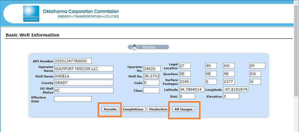
@bweth, please see attached screenshot. The permit pushbutton will give any available permits, and the All Images button will give a list of all of the available documents. Note that for older wells sometimes not everything is available.
@Bweth, for Angela 5, OCC order 718630, Case CD 201905137,
lists the breakdown as:
Section 16 15%,
Section 22 20%,
Section 21 44%,
and Section 27 as 21%.
This is much more reliable than the OTC Lease status in the production link that I mentioned earlier. The OTC lease data is sometimes right and sometimes not.
PeteR, Thanks for the info but, I must be doing something wrong as my screen (http://wellbrowse.occ.ok.gov/) does not give me the option of permits, images etc. When I give it an API the search results in the basic location info for the well and nothing more and it appears to stop there.
The starting point is knowing the legal descriptions where the minerals are located. With that information, he can identify companies producing from his inherited properties. He can start by examining any correspondence his father had with oil companies. Reach out to them and ask what is needed to have payment directed to him. May require a probate.
This post is not legal, tax or investment advice. Reading or responding to this post does not create an attorney/client relationship.