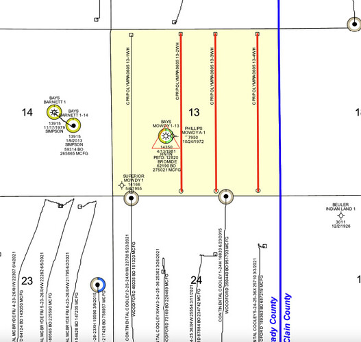
I was wondering if someone might explain if this is correct or an error? I realize everything is delayed until March 23. Please forgive my lack of the correct terminology. One document shows Grady and one shows McClain but both show Section 13 6N 5W. The Pooling application at OCC that I have subscribed to shows this- CD 2022-002299
Completed Well CostCodeCostCodes
AFE DATE:7/8/22
COUNTY: McClain County, Oklahoma
Sec. 13-6N-5W
Sec. 13-6N-5W
PROJECT: Drill and complete 5K HZ Woodford well
Olympia 0605 13-1WH
AFE:
Property:
0
0
FIELD: SCOOP
But the Exhibit 2 shows McClain County (I know they have included Section 14 in McClain County as well) but is this an error on Exhibit 2 shouldn’t that read Grady County? Also what is the field SCOOP listed above?
Case Number: CD2022-002299
Filing Date: Jun 14, 2022
Location: OKC
Program Area: Oil & Gas Conservation
Docket Type: Conservation Docket
Case Name: CASILLAS PETROLEUM RESOURCE
PARTNERS LLC (Applicant)
Status Active
13
6N
5W
Woodford
Grady
Sorry this is long thank you all for any of your knowledge on this. Don’t really know why I’m questioning this because I really have no knowledge on this but just seemed odd to me.
13-6N-5W is in Grady County. Most likely a clerical error so no cause for concern. It is on the McClain County line. I haven’t looked at the drilling permit/information but it is possible the surface location could be in an adjacent Section in McClain County.
The SCOOP field designation stands for South Central Oklahoma Oil Play.
@TODD_M_Baker does this show you anything? I think maybe it’s a clerical error as well. If they even do it still lol. It has been pushed up to March 2023 it’s like watching paint dry.
I am having a senior moment, I can’t figure out how to ask a question about Section 06, Township 09 North, Range 08 West in Grady County, OK. So I’m using a reply to ask it. In 2017 Linn Energy Holdings applied to drill a horizontal well in the above section and Section 07, T 09 N, R 08 W, but I think they went bankrupt. I had some personal problems and had to deal with them about that time. I’m just now getting back into reality and trying to figure out what happened back then and if anything might be happening in the future. United Energy has been operating a well in Section 06 for a lot of years. I would appreciate any info on Section 6 and how to ask a question on this forum. Thanks
We all have those sort of moments…
To ask a question, you post in the state and county where the minerals are. You can use the Counties tab above. So you posted in the right place. Usually folks start a new topic for a specific section, township and range.
United has the Horn well in section 6. No new leasing at this time. Last I see was in 2017. The horizontal well for 6 & 7 was not drilled. However, there are some permits in the eastern half of the township. Citizen has those, so time will tell if they move west.