Commodity returns


Teresa,
Yes, OK does have quite a bit of moving real estate in OK due to various thrusts, but the drilling and frac’ing themselves are not really the root causes. The geologic reasearch community is leaning more towards the reason being the disposal of the water into specific areas by commercial water disposal companies-which are getting water from oil & gas operators and other sources. Many of the wells are not properly disposing into the correct reservoir. Vast increase in the number of disposal wells and the increased volumes of water being injected are part of the equation. Lots of research going on, so we should wait and see what it finds out. Some disposal wells are doing just fine and others seem to be too close to known fault systems, so might be affecting the friction coefficients. I suspect there are quite a few factors and pinning it down to just one thing may be impossible.
Yes, I am a geologist and I have sat through hours and hours of scientific discussions about the topic. Quite a few universities and companies are putting their best researchers onto the issue.
We should all remember that Oklahoma is on one of the largest tectonic plates in the US and with all the drilling/fracking on these shifting plates it is bound to cause lots of quakes.
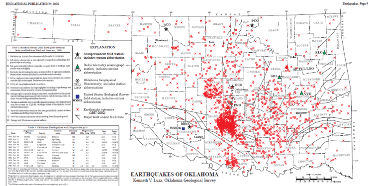
I think the shift in the area of the earthquakes is interesting.
From 1972 through 2007, the USGS recorded about two to six earthquakes a year in Oklahoma. But in 2008, earthquake activity began to increase, with more than a dozen earthquakes recorded that year. In 2009, the rate continued to climb, with nearly 50 quakes recorded — many big enough to be felt. In 2010, the trend continued.
There has also been a change in the distribution of the earthquakes.
From 1973 to 2007, the earthquakes were scattered broadly across the east-central part of the State. The events since 2008, however, have been more clustered in the vicinity northeast and east of Oklahoma City and generally southwest of Tulsa. This sequence of earthquakes was in this area.”
Here is a drilling rig infographic from Bloomberg. It goes to the county level.
Newby 1-7H was drilled in 2015 by Marathon Oil . It was completed in late October, so you should be getting a Division Order any day. Make sure they have your address. Davis Trust 1-7H was completed earlier. You should be betting payments on it.
Thank M Barnes. So you think there’s two wells? I’ll call Marathon tomorrow.
John, at least two wells. Call the mineral owners number at Marathon and get everything straightened out if you are not getting paid on the earlier well. They may be holding the money for you. The new one is probably not in pay status yet, but will be in a couple of weeks. Good time to get all your paperwork in order.
anything going on for Section 7 Township 03N Range 04W in Garvin County? I received mineral deed from my grandma a while back and trying to get any info I can.
Something from econobrowser.
http://econbrowser.com/archives/2016/04/productivity-gains-in-u-s-shale-oil
John Wilson, I just received a division order for the Newby 1-7H well from Marathon today in 7-3N-4W.
Fellow by the name of Bernardo Brandoa with Echo Energy left a message on my voicemail about my mineral interest in Garvin County. Looking at county records… looks like Echo is buying minerals up.
Jackie I spoke to the same guy.
Completion form 1002A filed yesterday with Oklahoma Corporation Commission for Eubank 1-10-3XH. Section 10 & 3, Township 3N, Range 4W. Looks interesting. Wish I could understand it. I wouldn’t sell.
Echo called me yesterday (May 23, 2016). That’s probably 4 or 5 calls in the last 6 months or so. Well, I don’t know much about these things, so I called the County Clerk to find out about the deed. Almost 20 acres. She also said she was sending some more paperwork for that area that I really needed to look into. Seems that I, together with my 3 brothers and sisters, also inherited from my mother another sizeable portion of Section 25, Township 4N, Range 4W. If anyone knows the latest information about this area, I would greatly appreciate your help. Thank you Rocky
Lynden, thank you so much for the information. I will certainly look at the link you provided.
If you have a brand new well, don’t sell…
M Barnes, I don’t know exactly what is on it. The little less than 20 acres is in my name but the rest was left to my mother’s heirs which is what the deed states that includes myself, a brother, and two sisters. The deed didn’t name us specifically but when the lady at the courthouse realized who I was and how I was related to my mother that had a different last name than mine because she remarried later in life, she sent me the other deed. So no one could contact us about the larger portion of the Section. I told the man at Echo what was sent to me from the courthouse; he seemed very interested, so much in fact that I’m trying to figure out who to contact to protect our interest. As I stated before, if anyone can point me in the right direction I would greatly appreciate it. Thanks, Rocky.
Rocky,
You can go to the OK Corp Comm electronic well data site
http://www.occpermit.com/WellBrowse/
Sections 26 and 23, Township 4N, Range 4W has a well, the Wertz 1-26-23XH that was spud in August of 2015 by Continental Resources. I suspect that they drilled but have not fracked.