Does anyone have any information about the immediate area within Gaines County my mineral rights are located? I have 640 net mineral acres. Any current production, permits to drill, newly drilled wells, etc. I’m new to this and haven’t quite figured out how to find this data online. The location is Section 51, Block H, D&W RR Co. Survey, A-60
Pitts Energy has permitted a horizontal well very near your section. Click on this link to open map viewer. Use the magnification bar on the left side of the map to zoom out a bit to reveal your section about one-half mile to the east.
Thank you, Sir. Does that map show that my section has had 2 dry hole attempts? I’m assuming a very long time ago? Do you know valuation? What would you say going rate (Cash Bonus) for my section is to lease for 3 years with a 2-year option?
You’re welcome. I suggest you contact Pitts Energy and speak with the land department. I believe a year or so ago Ring Energy leased tens of thousands of acres in north Gaines County from Devon for around $500/acre. It helps that you have the whole Section and are willing to do a 3+2 lease. And it will likely help even more if the Pitts well has been spudded and is showing promise. If you are able to get an offer, my guess is that it will be in the $450-750/acre range with a 25% royalty. PS Yes, two dry holes on your Section.
Brent, I see where Pitts Energy has 5 approved locations just NW of your Section 51 for horizontal wells (API 165-38677/678/679/685/745).
The targeted formation is San Andres… permitted for 5,300’.
GIS Map of Gaines County A-60/Section 51/Block H:
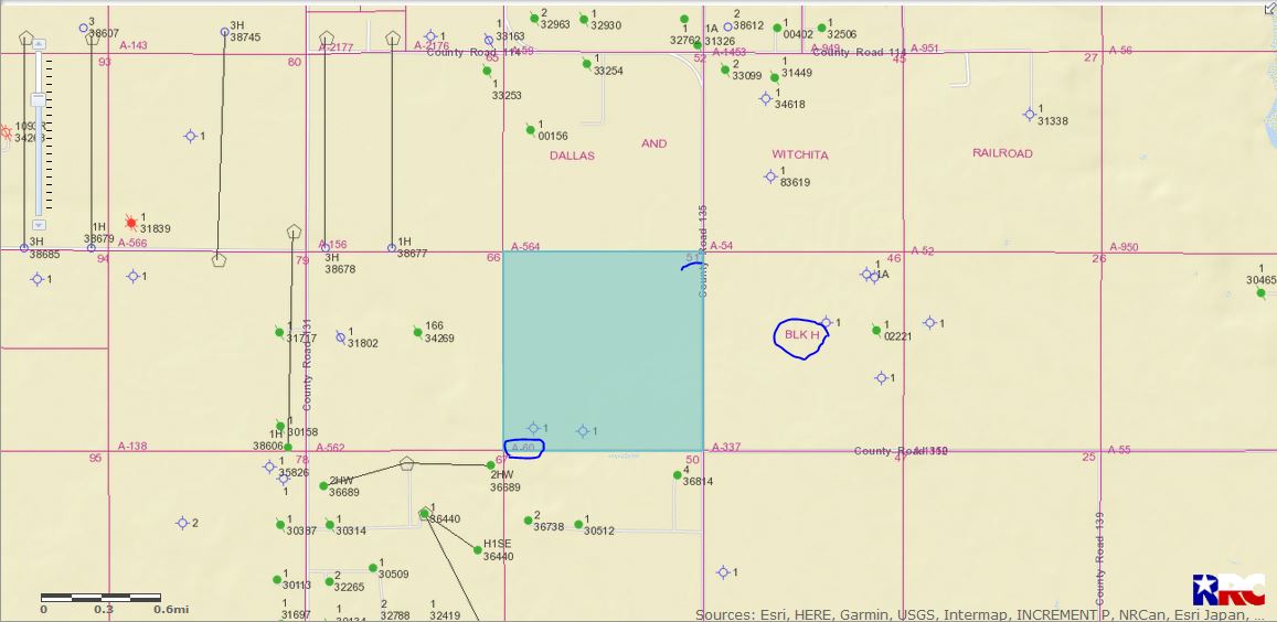
DOUBLE LEFT CLICK TO ENLARGE MAP