I was going through old paperwork of my mom’s and found a copy of a notarized Quit Claim sent to Scurry Co transferring her rights to me in 2007. I’ve never been contacted, and had all but forgotten about them. How do I go about getting information? Is there anything I should be doing? The rough center of the property in question lies at: 32°38’11.5"N 101°01’50.4"W. Thanks in advance for any guidance.
Is the quit claim deed recorded in county record? Does it have your address to find you? The cited location is not a legal description. If you post a legal description, then someone can provide information about activity and wells in that area.
Sorry. I’m trying to understand the paperwork I have. There is stuff going back decades. The last correspondence I have is between her estate and Gilmer Associates. The mineral right is listed as 1/36 of:
All NW/4 and the North 42 acres of the SW/4 of Section 157, Block 97, H&TC RR Co. Survey, Scurry County, Texas
I don’t know if this was recorded or not, but the address that was sent for me is correct.
1 Like
There is an old well-BLUM 1 in the NW4, which was completed in 2008. Last production was in 2011. Currently inactive. Bills, L. T. was the operator.
Was a Towle, Mary R. -1 in the SW4 which was plugged and abandoned. Trice Production.
Do you need a map just to have a feel for where it is?
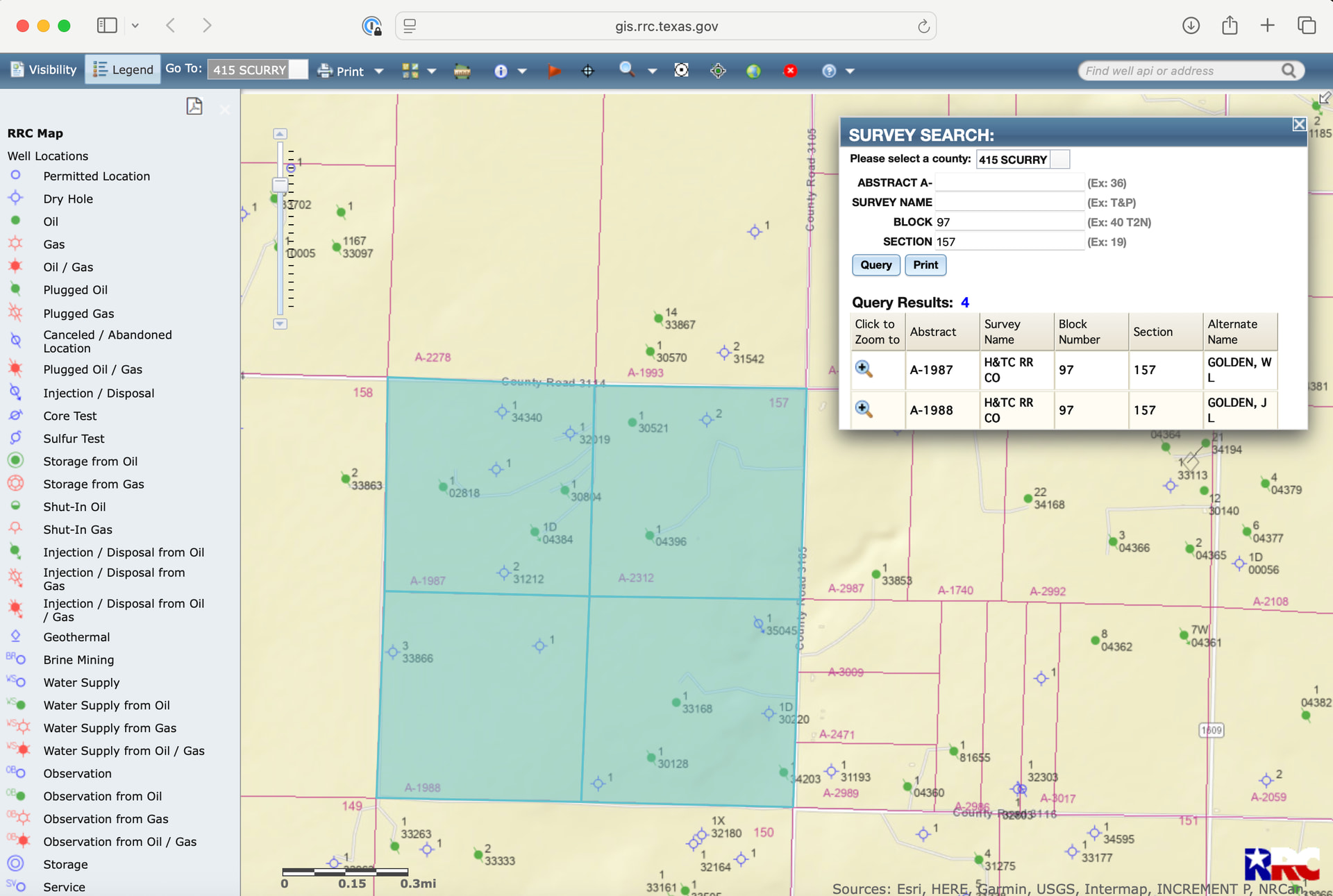
A map would be great. Thanks. Also, is there a web site where I can easily verify if I, or her, is currently the owner on record? I went to the Scurry Co main page and nothing stood out as applicable to mineral rights.
You can try www.Texasfile.com or www.courthousedirect.com to hunt for the deed chain of title.
Thanks. That was helpful. And discouraging to see this property is on the edge of what looks like a productive area.
I found a second folder of papers. This one has correspondence going back to the 1970s, when my grandfather owned it. Among those papers, I found another copy of the Quitclaim. This one was stamped and stapled to a notarized receipt from the Scurry Co clerk with a record date of Jan 8, 2008. I also found a printed email from one of my mom’s cousins from dated Nov 2007 referencing a lease “we signed last year” and discouraging her from taking the Nantucket offer to buy royalties.
I haven’t yet searched for myself, but this should mean I’m in the record, correct? And that would lead me to ask about what BLUM-1 produced, if anything from 2008-2011. Could this be part of the lease being referred to in the email? Should they have been in contact with me during this time?
I’ll keep digging. There is a lot here to process.
Bllum 1 was completed in 1975 and again in 2008. It produced at a couple of hundred barrels a month from 2008-2011, but nothing significant. It is the mineral owners’ responsibility to contact the operator if there is a change in ownership due to a death or a sale. If the operator does not know about you, they cannot pay you. It sounds like you have the quitclaim, but if the well was already producing and paying under one person’s name, it is possible that once they recompleted, they did not check the records again and didn’t know about you. Have you checked with unclaimed funds in TX. www.missingmoney.com
I spent the weekend reading everything I had and along with your information, links, and the RRC imaged document search, I was able to piece together a rough drilling history related to my claim back to the mid 1970s.
Unfortunately (for me), BLUM-1 is about 500 feet to the east of my claim. Another productive well, RIDESOUTH ‘A’-2, lies 200 feet to the west of my claim. The lease my mom signed in 2006 produced a dry hole. There was oil found in MCGAHA-1 in August 1976, but the well was capped in 1978. MCGAHA-2 was later repurposed into CLEMENTS-1D for salt water disposal. The 24 test results of MCGAHA-1 was 83 BBLS oil, 89 MCF Gas, and 6 BBLS water. FTP was 270 psi, Gravity 41. As far as I can tell, it never was in production. I couldn’t find test results for MCGAHA-2. I’m not sure what these values mean when it comes to what makes a “good” well, but these obviously weren’t it. Can you enlighten me?
Check the “as-drilled” plats for the wells to make sure where your acreage is with respect to the drilling spacing unit. The surface location is important, but the drilling spacing unit is the critical piece. Those numbers are not a good well! The total production was 2731 bbls oil and 3011 mcf gas.
The only plats I could find for BLUM-1 were attached to a Test Completion or Recompletion Report (Form W-2) from 1975. I’ll try to attach it. Am I correct that the drill spacing unit is the red square and it basically says the bore can be anywhere under the square? My acreage is all on the McGaha side of the S157. The plat I found for RIDESOUTH A-2 was similar as its square was fully inside of S158.
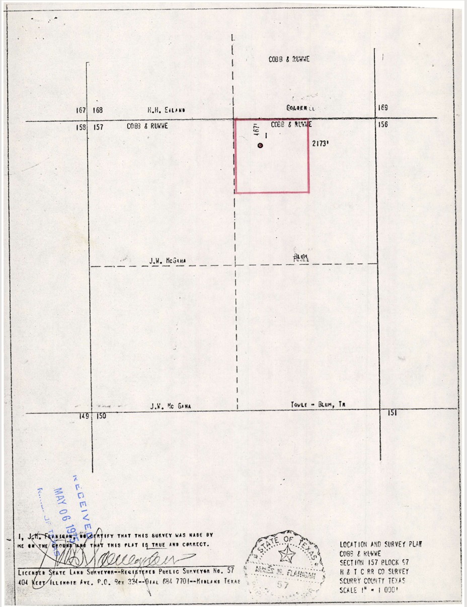
I get that, but this plat document is attached to the well test. The hole has already been drilled by this point. Doesn’t the plat then indicate the final locating of the bore?
It may be vertical and within the bounds