FYI to all! EOG has a permit pending as of yesterday (9/4) for a “Harwi unit” which looks like it will be off of their Wied pad (Francis unit pad). Maybe Nabors rig 1209 goes there first if they don’t have enough infrastructure in place on the Pecan Farm pad?? Curious how they come up with some of the names for these units?
Generally speaking, in my experience at least, units are named after the surface owner where the pad is located. Not always the case, though.
EOG also just permitted the “FRIEND” unit which is south of Francis using the same pad, and as previously mentioned the “HARWI” unit will be towards the west of Francis also same pad. Looks like they will have another unit going northwest of Francis also same pad. This does sort of confirm the 4 unit 1 pad strategy as mentioned about the Pecan Farm pad. I would guess same thing for the Blackshear, and the Blackshear units would be south of Blackshear and Parr units. Again a guess right now, but I will try to confirm that EOG will be moving 1 of the 3 rigs in Dorado to our area.
I drove by the Pecan Farm Wednesday afternoon and as of then all site prep (dirt work) looked to be complete. There was NO equipment installed though.
Also drove by Blackshear/Parr and even though everything looks ready to go and there are throngs of people on site I’m not sure that they’ve actually started drilling.
Blackshear has been drilling for at least a week now, they had the well shut down almost 1 week, then started it up again about 5-7 days ago, and it is still going. I saw pipe go up from the ground on the slanted rack, go into the rig and the rig drilling it down. I thought they had completed the drilling up to starting the horizontal drilling process, but today it looks like that they are not there quite yet. As far as the Pecan Farm pad, as far as I know they have not started the construction of the gas pipeline yet. It will for the most part be in the units, but some of the pipeline will have to attach to the main, which I believe will be somewhere bordering or on the Mobley Ranch tract. You can see some pipeline easements, and surface site recordings just recently in Lavaca County records.
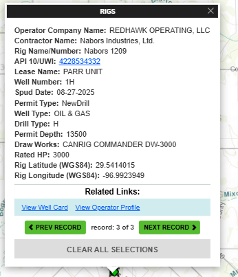
After looking at ENVERUS, this well that is presently drilling in the Parr 1H / spud on Aug 26th. Permit for a 12,000’ lateral that will be drilled in SE direction (downdip).
The earlier Blackshear 1H was drilled from the same pad in a NW direction. Spud on March 28th. Based on the directional survey, this was a 10,200’ lateral with a TVD of 12,550’.
Yet another EOG unit “MULINGE” permit out today. This is the 4th off the same Francis pad. Francis to the northwest and Harwi underneath it…this Mulinge is to the east of Francis with Friend underneath it. Again this looks like the plan for the rest of the EOG units. Redhawk can put 2 on the south of Blackshear and Parr which would end on the Lavaca river. EOG then can put 3 sets of 4 units running south that would meet on top of these 4 (Francis) units. There also seems to be a set of 4 units that can north of Blackshear/Parr and end on the south of the Pecan farm 4 units…looks like a plan to save some money and hold all the 38,000 acres EOG has leased. This plan would bring a total of 28 units with still 2 units going with north horizontals to the east of the Modern Energy unit off of FM1295…30 units @ 1280 acres each…We shall see……
I’m curious about your 38k acre figure. Does that include Fayette County leases? Courthouse records indicate that they leased all the way to where IH10 crosses 90 east of SBG.
They still have a ways to go to prove up everything depending on pecan farm results of course.
On a previous post I had put that EOG might be taking a rig from the Dorado section of south Texas, this was wrong, they only have 1 rig there and that area very gassy sends most of its production to Corpus I believe. EOG has 4 rigs in the Eagleford (not Dorado). One has been here mainly in Gonzales County…but rumor has it they might send one of the 3 rigs that are southwest of us several hundred miles to drill to hold this acreage. EOG does have options due early in 2026, and by summer 2026 a LOT of options due…someone had posted EOG would not hesitate to pay this but I heard they are on cost-cutting missions, and even 15,000 acres with options due would cost 18 million just to mineral owners plus other cost….they do not want that…at least that is what I was told recently. The rig move is just a rumor at this point, or should I say discussions are happening…but if they move rig 1209 to Francis pad…would not get here til end of this month and drilling out 3 new wells would take to end of December…Pecan Farm?? Seems like a rig move would make sense….we will see what they decide…
This figure 38,000 does not include Fayette County.
However, EOG released the fact in their 1st quarter report (that we already knew) that they had leased around 32,000 acres…and since then through today, they have leased or acquired (assignment) another 10,000+ acres which would include any Fayette County acreage. The 38,000 acres is the actual acreage in proposed units in Lavaca County. These are the 30 units not counting the Finn unit south of Shiner, and what might go up around there…maybe 1-2 more units but based on Finn results was told not likely right now. I have a map which indicates proposed unit locations.. all 1200-1280 acres in size. 6 of these units have been permitted now. Originally heard Pecan Farm was a 2 unit “TEST” on 1 pad…but now the 4 unit pad makes more sense…but…anything north or even south of Pecan Farm will depend on results…and out of that 30 units 4 are Pecan Farm and 4 units are south which borders Blackshear/Parr..All of those will only happen if the results warrant it. However the other 14 units between Francis/Mulinge and Blackshear/Parr have been proven….the 2 units east of Modern Unit “Grover” which would have a northern direction are also a test… and they might be lower Eagleford instead of chalk…however, as things constantly change I heard this acreage which is way too small to make a NW/SE lateral on could be included in an existing unit to run a 3-3.5 mile laterals on in the chalk. A lot of this is also depending on some Baytex tracts expiring in the next couple of months in that area.
You’ve provided a lot of great information. Thanks. Time will tell at this point.
I’m just entering year two of my Redhawk lease as are most others in my area so I guess they have some wiggle room in that regard.
Redhawk leased about 6500 acres in Fayette County starting around March 2024. They took a hiatus around December of last year to see the results of their 1st test well Blackshear. The well logs during the drilling process showed huge potential so they sent the landmen out again around May 2025…now only a few of those leases have been recorded but many more to come since there are a lot of holes to fill in. The only caveat here is that even though the well logs looked better than the Francis unit (which they love) Blackshear’s real numbers fell short, to numbers below Francis, but still profitable—not a 7.5 month payback as planned…looking to be around 12 month payback depending on crude/gas prices in the near future. I had heard several days ago that Redhawk was told to cease leasing operations on those fill in Fayette County tracts (not Pecan Farm—at least 2 of those units are mineral secure)….but since then heard that the official notification has yet to be sent. Redhawk and EOG are still negotiating leases in the proven area… a lot due to the final title search results…but still some holdouts since Redhawk is $700/acre vs EOG $1200…both 22% royalty. Hopefully Pecan Farm does come in with great results…a lot riding on it…
It will also be really interesting to see what KEW does if EOG does end up drilling the Pecan Farm and proves up the area. I will be anxiously awaiting to see what happens… If the Pecan Farm wells are drilled NW, it’ll come awfully close to the SW corner of my family’s acreage.
I found myself being impatient for the Pecan Farm paperwork until I saw the paperwork for Friend and ‘Lemon’ Mulinge. (Dad joke. Sorry.)
Egad. Running title and producing plats for that probably drove some people to drink. So we wait patiently for them to catch their breath.
KEW and Redhawk leasing is all over the place in Fayette County. They crisscross tracts mainly in the following surveys: Levi Bostick, K Crier, Thomas Taylor, J. Bell. Does not look like either company has enough continuous acreage for a unit with the exception of the Wolters property… there are 2 tracts, one 1000 acres, the other 700 acres… this might be on the site of the Wolters well which is operated by Elliot Oil. This well went down to 12,571 feet and shows it is still producing. Most leases hold the lowest depth plus 100 feet… and I am guessing Redhawk would be 13,000-14,000 feet… so they could be on this site. Either way you only need 1200 acres for a Redhawk unit. There are also about 4-5 tracts that Redhawk leased that are around 500 acres each. Otherwise it is like a checkerboard. Redhawk would probably not want a JV… so they could buy the leases from KEW, but I’m sure they will wait on Pecan unit results… at least the well logs… and as of this morning Redhawk still leasing pieces of what is left in those surveys.
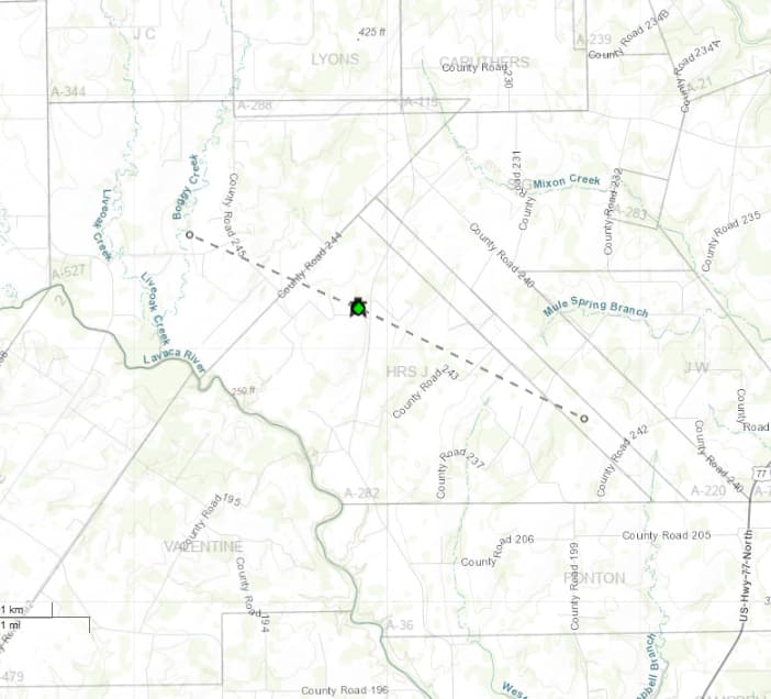
Monster Rock Unit now permitted by Redhawk. This one goes southeast of pad location, crossing US 77. If this is a 4-unit pad this unit is in the northeast quadrant.
Interesting. It’s oriented more North-South than I was expecting considering Blackskear/Parr. Also, I had seen pink tags on the fence directly across 77 from County Road 226. Maybe it was for something else. In any case, I’m anxious to see how it goes.
Not surprised this was first unit permitted, since I believe the pipeline runs just west of US 77, and now they can work on that project… it should only go through tracts in this unit.
Hopefully, rig 1209 on Parr goes here next… we’ll know in about 2-3 weeks… I’m also guessing that a second unit to the northwest will be permitted so they can check the results to the west… plus once they run the water pipeline all the way from County Road 240… etc… they should just do it one after another… and 2 red topped 8-foot poles were on the pad.