Two new Horizontal wells are drilled side by side on the next land parcel over, the rigs were unlike any of the rigs I’ve seen before drilling in the FTW area during 2008 or the rigs I recall from the vertical wells from the early 90’s growing up. This rig was absolutely massive and the two pad sites were easily 10 acres right next to each other. We never received a division order for the new wells although another family member did. Is that normal? There ended up being a problem with a passing of my grandfather creating an issue which is what the landman ultimately contacted us about. The issue is the allocation designations, I would have likely objected to the acre amounts in the allocations primarily due to the bore path traveling through our property the longest runs as I’ve seen in the survey plats.
DISTRICT: 05 LEASE/ID: 288208 & LEASE/ID: 288218
We are receiving payment for 288218, however nothing for 288208…
This is where I’m needing some guidance on how things are documented and/or if I’m simply not understanding things correctly, which I admit could be all on me being incorrect in how I understand things.
I just thought it was odd that the drilling permits for the well were not being paid for list the productive bore path through a gas unit on our property??? The Well we are being paid for right next to it seems to show in the survey the bore path as such us being in it etc., but the P-16 for the well we get paid for has the other horizontal well listed as a member in the allocation. The P-16 for the well we aren’t being paid for list all the wells in the allocation and the acre amounts etc.
It just seems weird maybe the paperwork is funky, or maybe I’m just not understanding things as I should. I would figure the tax man wouldn’t just let them pipe one allocation well into the very next one all willy-nilly… To me it sorta feels like there are folks not being paid right but as I said before I could be absolutely wrong… I don’t want to start asking questions and coming off like an ahole for not understanding things correctly. Any insight anyone could provide would be helpful so thanks in advance.
These are allocation wells, with wellbores which cross several units and some non-unitized lands on plats. The entire acreage on the plats is not a unit. Royalties will be paid to the owners of the exact non-unitized tracts crossed by the wellbore based on the proportionate length of the producing wellbore. If your minerals are in one of the units, then you would be paid according to the length within the unit. For example, do you own a 5-acre plot within a large tract of 100 acres? Or do you own 5/100 of all the acres within the 100 acres? The ownership may be different for you and the other family members. The answer also depends on the legal documents signed by your grandfather or his heirs. Is there an oil and gas lease or are you unleased mineral owners? What is in the document that you or someone signed when the “problem” was raised? Is it possible that you were given an option of a larger royalty decimal in a single well which crosses your tract or a smaller royalty decimal in multiple wells some of which do not cross your tract? Allocation wells can be complicated and so more specific information is needed.
I’m not sure of an easy or the best way to give you the info you need lol…
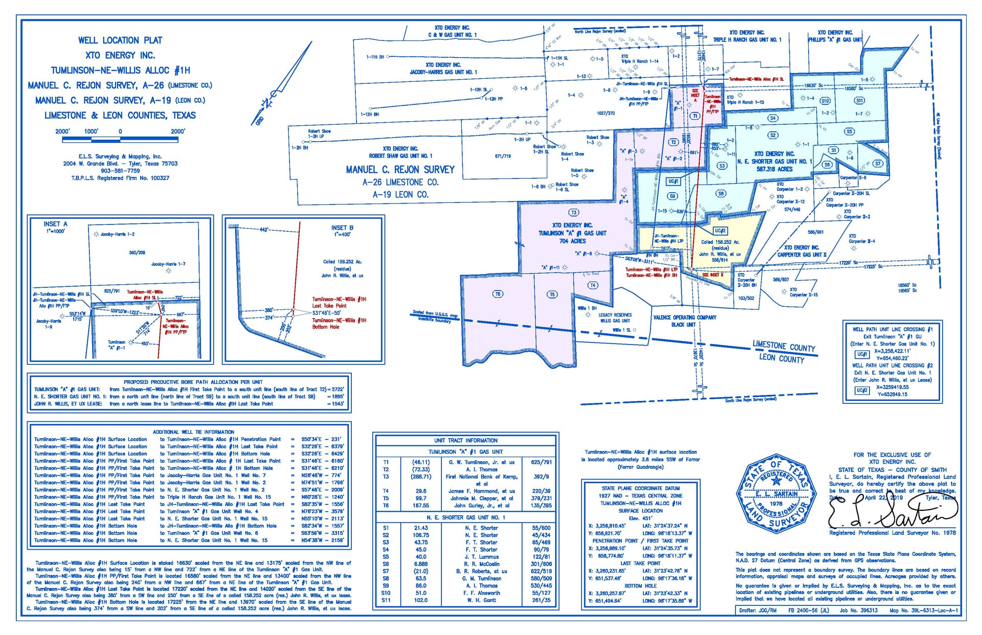
Yes, a lease was signed by my grandfather and it might be worth taking a trip to the courthouse I would guess to get a copy of what his original agreement was. Like I said I most certainly could be wrong but if this forum will allow my image attachment of the plat which does show both bore paths in question. We are S1 S2 S3 & S4 in the plat… S1, S2 would be grandpa and S3, S4 being great grandpa. You said that each family member could have differing agreements so I’m thinking it would be neat to try and locate what great grandpa signed and compare it to what grandpa signed. Why would we not be seeing a well stanza in the royalty payouts for this well TUMLINSON-NE-WILLIS 1H when it’s plain as day the other ALLOC referred by the blue bore path also passes through? Bore path of 1895’ for this well.
Here is the plat for the other well JH-TUMLINSON-NE-WILLIS 1H, again we are listed in as S1, S2, S3 & S4. I understand it’s a slightly different path etc. Bore path of 1906’ for this one…
So this is why I’m confused because both these wells seem to have tie points to our gas units, pass through our gas unit and we only receive royalties for the TUMLINSON-NE-WILLIS 1H and have never even seen a mention of the JH-TUMLINSON-NE-WILLIS 1H nor received a division order for only just the single well?
Is it wrong for me to be seeing this as such, or is this a valid concern? I know each of these wells’ output is expected to be different but I figure if the bore path for these two wells passes our unit then we should have received two division orders for two drills?
I agree that you should contact XTO about getting in pay for the second well. How are you personally being paid on the first well if you never received a division order and returned a W-9? I assume that you are also being paid on the older unit. Possibly your interest in second well is still in your grandfather’s or great-grandfather’s name and title has not corrected. Possibly you are in suspense because division orders were sent out and yours was lost in the mail and so never returned. Be sure to include your owner number on any correspondence. Exxon is handling all these inquiries relating to XTO leases and division orders. Division Order / Lease at divorder@exxonmobil.com
So I think I figured out what’s going on but now what the heck do I do about this? Is there anything or is it just a waiting game? That’s from the RRC website under their docket section.
OG-21-00006908: Application of XTO Energy Inc. (Operator No. 945936) for an exception to 16 TAC §§3.11 and 3.12 to have directional surveys accepted that were not submitted and certified directly by the directional survey company, for the Jacoby Harris-Tumlinson (RRC Gas ID No.
Lease, Well No. 1H, Farrar (Cotton Valley Lime) Field, Limestone County, Texas; District 05.
BM
Further Digging:
So the request was granted by the RRC… Now what? It’s been a while; the show monthly production started in Dec 2020. How does one determine if they are owed interest on them holding back payments?