Kentucky boy here needing some assistance in determining if lease offer is fair.
My family owns 100 acres in Eddy County, New Mexico, Section 24, Township 18S, Range 25E. This has been in our family over 50 years and we have leased multiple times over the years but we let it lapse for the last two years. We received an offer several months ago so I’m investigating for the family what a fair lease offer would be. Some members of the family are distant relatives but others are close siblings and first cousins. I have ownership of 12.5 acres and am trying to find out on behalf of myself and other family members what would be a fair net mineral acre term lease and % royalty for a 3-year lease with an additional 2-year option.
We also have 80 acres in Chaves County, Section 34, Township 15S, Range 26E but no offer to lease on this acreage for a number of years. If anyone might have information for this area this would also be helpful.
I spoke with an attorney in Albuquerque and he looked over the contract language and made a few suggestions but he isn’t an O&G attorney. If anyone can recommend one in the Eddy County area I would appreciate it.
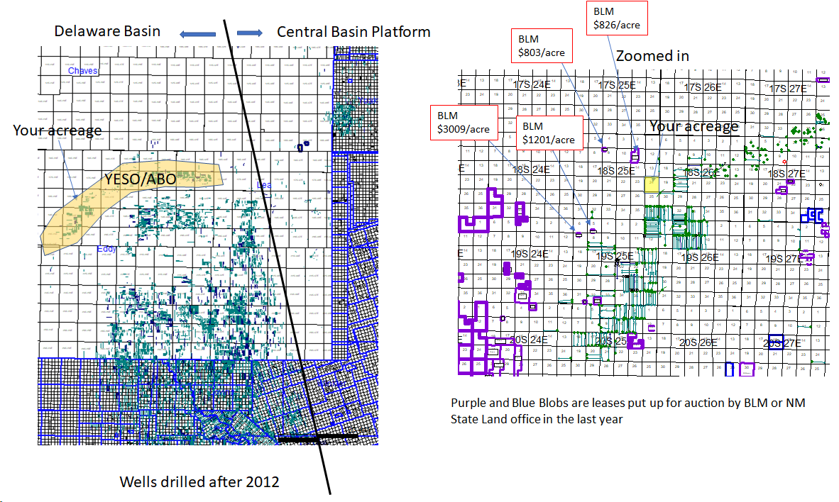
Here is some basic info on where the Eddy County stuff is. Not in the “hot” part of Eddy County. The BLM has sold a few leases close to yours via auction in the last 6 months, those prices have gone from $800/acre up to $3000/acre (see map). Those are 1/8 royalty leases with a 10-year term. So… would guess for a 3/16 royalty lease you’d be lucky to get offered $1k/acre. Again, just a guess, but at least a guess backed up by public info on lease sales.
Fwiw, a company called Percussion has made some strong Yeso wells in the past year in Township 19S, Range 25E, and is now marketing their entire position along the Yeso trend. That may push some prices up a little bit nearby. Not much going on Chaves County way. Good luck.
18 South 25 East is on the Northwestern Shelf. Delaware Basin starts just southeast of there.
I’d attach a pic but I’m on my phone and too old to figure out how to do that. Just google Northwestern Permian Basin pics and you should be able to see a cartoon of how the various parts of the Permian are laid out.
Where are you finding these maps and in particular the one on the right? I have received an offer on ORRI and would like to see horizontal activity in my area.